Valdez
Above 3,000ftConsiderable
1,500 to 3,000ftConsiderable
Below 1,500ftConsiderable
Degrees of Avalanche Danger
Avalanche Problems
Problem 1
Human triggered avalanches are likely 1-2+ feet in depth. Our area has received slow incremental snowfall since 4/9, delivering a wide range of new snowfall amounts to our forecast area. Expect to find 1-2+ feet of new snow since the 9th that recently turned upside down due to an increase in temperature and continued snowfall on 4/14. This set up on its own would be enough to elevate the avalanche hazard, however there are other factors that will add to the hazard today. North winds are forecasted to increase today up to 25 mph. This may not sound like a lot, but will be sufficient to redistribute the new snow into areas of wind slab (see problem 2). In addition, the intensity of the April sun will be promoting wet loose activity on solar aspects and stiffening storm slabs which will increase the sensitivity of new snow in all areas but high elevation north aspects (see problem 3).
The storm snow avalanche problem can be assessed by paying attention to new snow amounts, checking the sensitivity with the new/old interface and taking into account what affects the wind and sun has had on the surface in the area where you choose to travel. Pay attention to red flags such as shooting cracks, collapsing and natural avalanche activity. All of these suggest unstable snow that is capable of producing human triggered avalanches. Cautious route finding and careful snowpack analysis will be very important for safe travel in avalanche terrain today.
This avalanche problem will be less of an issue in areas that have received lower snowfall amounts.

Likelihood:
- Almost Certain
- Very Likely
- Likely
- Possible
- Unlikely
Size:
- Historic
- Very Large
- Large
- Small
Trend
- Increasing
- Steady
- Decreasing
Problem 2
Northeast winds are forecasted to increase today with gusts to 25 mph expected in wind channeled terrain and along high elevation ridge lines. There is a lot of new snow available for transport. Winds in the mid 20 range may not sound like a lot, but is definitely sufficient to redistribute new snow into stiffer slabs that will be more sensitive to human triggers. The moderate winds that we are expecting can make identifying wind slabs more difficult. Pay attention to wind redistribution in the area you choose to travel and expect to find increased sensitivity in the surface snow on the lee side of high elevation ridge lines, cross loaded terrain and on the lee side of micro terrain. Wind slabs may have a pillowed look and will be stiffer at the surface than the underlying snow.

Likelihood:
- Almost Certain
- Very Likely
- Likely
- Possible
- Unlikely
Size:
- Historic
- Very Large
- Large
- Small
Trend
- Increasing
- Steady
- Decreasing
Problem 3
Wet loose natural avalanche activity is likely today. The amount of activity we receive today will depend on the amount of cloud cover that remains throughout the day. If the sun comes out wet loose activity will be likely on east and west aspects at low elevation, and south at all elevations up to 6000′. Steep rocky terrain will be the first areas to be affected. So far this season wet loose activity has been below average. Generally by this time of year steep solar aspects are beginning to lose mass by way of natural wet loose avalanche activity. Many of these areas have recently gained mass, creating the potential for more substantial activity once temperatures rise to seasonal norms and wet loose/ wet slab activity begins in earnest. Temperatures look to slowly stair step up this week but a drastic change is not yet in the forecast.
Timing is key in avoidance of this avalanche problem. Pay attention to the amount of warmth that is being transferred into the snow surface (Is it becoming moist-wet?). Avoid traveling on, or being exposed to, steep solar aspects as snow surfaces are becoming moist-wet.
Likelihood:
- Almost Certain
- Very Likely
- Likely
- Possible
- Unlikely
Size:
- Historic
- Very Large
- Large
- Small
Trend
- Increasing
- Steady
- Decreasing
Problem 4
Weak snow exists at the base of our snowpack. This weak snow is currently unlikely to be affected due to the strength of old wind affected snow at the 3/17 new/old interface. Depth hoar may become a concern later in the season if our area returns to a period of major snowfall and the very strong wind damaged layer at the new/old interface starts to break down and lose strength within the snowpack. As very hard wind slabs break down within the snowpack, a person or machines weight will have a more direct affect on weak layers at the bottom of the snowpack. In addition, the increasing intensity of the sun will be putting pressure on deep layers during the heat of the day.
This problem is difficult to assess. if we do see deep slab avalanches begin to occur in our forecast zone, they will likely first show up on south aspects. This has not occurred yet, but would be a clear indicator of an increasing potential to see this avalanche problem on other aspects.

Likelihood:
- Almost Certain
- Very Likely
- Likely
- Possible
- Unlikely
Size:
- Historic
- Very Large
- Large
- Small
Trend
- Increasing
- Steady
- Decreasing
Avalanche Activity
Below is a summary of observed Avalanche activity from the last 7 days. Avalanches that were noted earlier in the season can be viewed by clicking the link below.
If you trigger or observe an avalanche consider leaving a public observation.
4/9- Skier triggered D2 avalanche reported on a wind loaded NW aspect of Berlin Wall ~5400′. Skier was caught and carried, but not buried/ no injuries.
Small wind loaded pockets D1-1.5 were observed to be sensitive to human triggers in cross loaded terrain on Billy Mitchell.
4/7- Numerous D1-1.5 natural dry loose avalanches observed that occurred mid storm 4/5-6. No step downs observed.
Several small (D1) human triggered avalanches were observed along the road corridor where the new snow had been wind affected.
4/6- Skier triggered D1 reported in Gully 1 on a wind loaded convexity.
Weather
Check out our updated weather tab! A collection of local weather stations are available for viewing with graphs and tabular data included.
NWS Watches, warnings and advisories
NONE
NWS Point forecast for Thompson Pass
Date                     Saturday 04/15/23       Sunday 04/16/23
Time (LT)          04    10    16    22    04    10    16    22    04
Cloud Cover        BK    OV    OV    OV    OV    OV    OV    OV    BK
Cloud Cover (%)    60    75    85    85    85    85    75    70    65
Temperature        21    25    33    25    21    26    33    25    20
Max/Min Temp                   33          20          33          19
Wind Dir           NE    NE    NE    NE     E    SW     W     W    NE
Wind (mph)         13    17     6     4     1     3     3     4     5
Wind Gust (mph)
Precip Prob (%)     0     0     5    20    30    20    10    10     5
Precip Type                           S     S     S     S
12 Hour QPF                  0.00        0.02        0.03        0.01
12 Hour Snow                  0.0         0.0         0.0         0.0
Snow Level (kft)  0.2   0.3   1.1   0.7   0.4   0.3   0.8   0.4   0.2
Click on link below for Thompson Pass weather history graph:
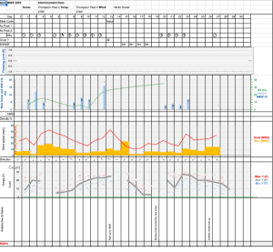
| Date:
04/15 |
24 hr snow | HN24W* | High temp | Low temp | 72 hour SWE* | April snowfall | Seasonal snowfall | Snowpack Depth |
| Valdez | .5 | .35 | 35 | 27 | .5 | 11 | 248 | 48 |
| Thompson Pass | N/O | N/O | N/O | N/O | N/O | 12 | 438 | N/O |
| 46 mile | N/O | N/O | 42 | 21 | N/O | ~5 | ~116** | 50 |
*HN24W- 24 hour Snow water equivalent in inches
*SWE– Snow water equivalent
**46 mile seasonal snowfall total begins December 1st.
Additional Information
Click on the link below for a running summary of the seasons weather history.
Announcements
The avalanche hazard is Considerable at all elevations. Multiple avalanche problems exist today that will be accentuated by the strong April sun. A long duration incremental snow fall event ended yesterday with rising temperatures. Expect to find top heavy storm slabs 6- 18 inches deep that are sensitive to human triggers above 2000′. New snow amounts from the latest storm will vary greatly from place to place, as will storm snow sensitivity. North winds are forecasted to increase today which will redistribute new snow, increasing sensitivity of snow at the surface in wind loaded areas. Last off and probably most important will be the strong April sun, which will promote natural wet loose activity on low elevation east and west terrain as well as south aspects at all elevations. Careful snowpack assesment and cautious route finding will be necessary for safe travel in avalanche terrain today.
Posted by Gareth Brown 04/15 8:00 am.
For a description of current avalanche problems, weather information, season history and more click the (+ full forecast) button. Avalanche forecasts will be issued Wednesday-Sunday through April 30th.
If you have pictures of recent natural or human triggered avalanches or notice signs of instability such as shooting cracks or collapsing, leave an observation to help improve forecast accuracy.