Valdez
Above 3,000ftConsiderable
1,500 to 3,000ftConsiderable
Below 1,500ftConsiderable
Degrees of Avalanche Danger
Avalanche Problems
Problem 1
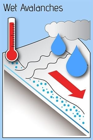
Temperatures have been at or above freezing for the last 48 hours with heavy rain occurring at 6 am at sea level. The initial shed of wet loose avalanches has already occurred near sea level with the onset of above freezing temperatures on Tuesday (1/23). As heavy rain is saturating further into the snowpack human triggered and natural wet loose avalanches will be likely today. These have the potential to be large depending upon the terrain you are traveling in. Large open slopes at low elevation will be dangerous until temperatures drop below freezing and a supportive crust forms at the surface.
Wet loose avalanches have the potential to step down to weak layers deeper in our snowpack that could create much larger avalanches. If you choose to recreate in the Maritime climate zone today pay attention to the terrain you are in. Avoid traveling in or above terrain traps and realize that the potential size of wet loose avalanches directly correlates to the size of the slope.
Likelihood:
- Almost Certain
- Very Likely
- Likely
- Possible
- Unlikely
Size:
- Historic
- Very Large
- Large
- Small
Trend
- Increasing
- Steady
- Decreasing
Problem 2
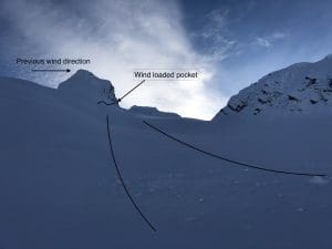
Above 2000′ storm slabs are building along with moderate to strong east winds. It is likely that upper elevations have received 12-24 inches of snow in the last 48 hours with an additional 8-12 possible today. This new snow is heavier than the snow beneath creating an upside down snowpack at the surface that will be susceptible to human triggers on slopes steeper than 32°. Wind loaded and convex terrain will be the most sensitive.
New snow will need time to settle and bond to the underlying snowpack. In the meantime Human triggered avalanches 1-3 feet in depth will be likely and natural avalanches will be possible.

Likelihood:
- Almost Certain
- Very Likely
- Likely
- Possible
- Unlikely
Size:
- Historic
- Very Large
- Large
- Small
Trend
- Increasing
- Steady
- Decreasing
Problem 3
Weak snow exists near the base of our snowpack in all three climate zones. The weather we are currently experiencing is putting these weak layers to the test and the likelihood of natural or human triggered avalanches has gone from unlikely to possible. It is unclear how much weight (rain or new snow) these layers can accept before failing. Realize if these layers do reach the tipping point very large avalanches would be the outcome. Significant weather that we are currently experiencing is when deep avalanches generally occur. The best mitigation technique, is avoidance of large avalanche terrain while a test of the snowpack is underway.

Rounding facets near the base of our snowpack from Cracked Ice at 4000′ on 1/11.

Likelihood:
- Almost Certain
- Very Likely
- Likely
- Possible
- Unlikely
Size:
- Historic
- Very Large
- Large
- Small
Trend
- Increasing
- Steady
- Decreasing
Avalanche Activity
Below is a summary of observed Avalanche activity from the last 7 days. Avalanches that were noted earlier in the season can be viewed by clicking the link below.
If you trigger or observe a natural avalanche consider leaving a public observation.
1/21- Several D2 natural avalanches were observed on wind loaded slopes that failed at the 1/14 BSH interface. These probably occurred on 1/19. Avalanches were observed on Hippie Ridge South aspect, RFS Northwest aspect, Cracked Ice Northwest aspect and Python (Cherry couloir) East aspect. These all appeared to be 1-2 feet deep.
1/20- Numerous large (D2) wet loose avalanches released from steep planar slopes in the Port of Valdez. These were caused by a foot or more of snow falling with temperatures rising to 40° F at sea level directly following. No step downs noted.
1/17- Numerous wet loose point release were observed on solar aspects in the Port of Valdez. Most of these originated from rocks were the suns energy permeated into dry snow and caused surface snow to become upside down. No step down slab avalanches were observed.
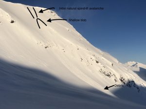
-Small (D1) spin drift avalanches on the lee side of Tones Temple ridge triggered a small slab at the 1/14 BSH layer.
Weather
Check out our updated weather tab! A collection of local weather stations are available for viewing with graphs and tabular data included.
NWS Watches and warnings
NONE
NWS Point forecast for Thompson Pass
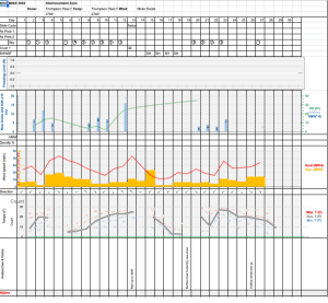
Date               Wednesday 01/25/23      Thursday 01/26/23
Time (LT)          06    12    18    00    06    12    18    00    06
Cloud Cover        OV    OV    OV    OV    OV    OV    OV    SC    SC
Cloud Cover (%)   100   100   100   100   100    75    70    50    40
Temperature        30    31    32    28    27    28    27    22    19
Max/Min Temp                   33          26          30          17
Wind Dir            E    SE     S    SW    SW    SW    SW    SW    NE
Wind (mph)         21    12    11    11    13    13    10     2     3
Wind Gust (mph)    33    25          23    25
Precip Prob (%)   100   100   100    90    80    40    20     0     0
Precip Type         S     S     S     S     S     S     S
12 Hour QPF                  0.40        0.24        0.12        0.01
12 Hour Snow                  3.6         2.2         1.1         0.0
Snow Level (kft)  2.4   2.4   2.2   1.4   1.0   0.8   0.4   0.1   0.1
Click on link below for Thompson Pass weather history graph:
| Date:
01/25 |
24 hr snow | HN24W* | High temp | Low temp | 72 hour SWE* | January snowfall | Seasonal snowfall | Snowpack Depth |
| Valdez | 0 | .7 | 37 | 30 | 1.72 | 39 | 136 | 47 |
| Thompson pass | N/O | N/O | 32 | 27 | N/O | 63 | 250 | 44 |
| 46 mile | 4 | .7 | 40 | 32 | N/O | 32 | ~66** | 40 |
*HN24W- 24 hour Snow water equivalent in inches
*SWE– Snow water equivalent
**46 mile seasonal snowfall total begins December 1st.
Additional Information
Click on the link below for a running summary of the seasons weather history.
Announcements
The avalanche hazard Is Considerable at all elevations in the maritime climate zone. Rain on snow will make wet loose human triggered avalanches likely below 2000′. Above 2000′ storm slabs are building that could be reactive to human triggers 1-3 feet in depth. Very conservative terrain choices will be necessary for safe travel in avalanche terrain if you decide to brave the rain today.
Posted by Gareth Brown 01/25 8:15 am.
For a description of current avalanche problems, weather information, season history and more click the (+ full forecast) button. Avalanche forecasts will be issued Wednesday-Sunday.
If you have pictures of recent natural or human triggered avalanches or notice signs of instability such as shooting cracks or collapsing, leave an observation to help improve forecast accuracy.