Valdez
Above 4,000ftModerate
2,000 to 4,000ftModerate
Below 2,000ftModerate
Degrees of Avalanche Danger
Avalanche Problems
Problem 1
Over the last few days stability concerns have revolved around wind loading of the 4-12 inches of new snow that has slowly accumulated over the last week. Winds have been calm in many areas the last few days, making windslabs only present in specific-isolated areas. The lee side of high elevation ridge lines and cross loaded gullies would be the most likely places to encounter this avalanche problem. Watch for signs of unstable snow including collapsing, cracking and recent avalanche activity.
Today will likely see similar conditions, unless the New Years storm arrives early than forecasted. In that case, expect for the surface snow to become upside down with warming temperatures. This change would create the potential for widespread storm slab instability in steep terrain.
Pay attention to the weather. If the forecast proves correct and the next storm arrives overnight then the hazard will stay at moderate today. If heavy precipitation and rising temperatures arrive earlier than forecasted, expect the hazard to be higher.

Likelihood:
- Almost Certain
- Very Likely
- Likely
- Possible
- Unlikely
Size:
- Historic
- Very Large
- Large
- Small
Trend
- Increasing
- Steady
- Decreasing
Problem 2
Faceted snow near the base of the snowpack has been identified in all three forecast zones. In most locations above brush line, faceted snow is capped by pencil-knife hard wind affected snow. This has created a strong bridging affect above 3000′, making a person or machines weight unlikely to directly affect these layers. Below brush line where a more protected snowpack is in place, significant facets exist in the bottom half of the snowpack.
It has been 2 weeks since the last significant snowfall event, and stability tests that directly target these layers have not been producing significant results above brush line. Below brush line propagation in stability tests was observed as recently as 12/29 in the Continental zone.
Persistent weak layers are tricky to assess and are notorious for surprising people. As long as temperatures remain cold and our snowpack is thin, these weak layers will continue to lose strength. It is likely that facets will reactivate in the future when stress is being applied through dramatic changes in weather such as: significant snow accumulation or rapid warming. Maintaining safe travel protocols such as skiing one at a time and avoiding traveling in or above terrain traps will increase your safety margin.
The most likely areas to trigger a persistent slab avalanche would be in steep terrain that was protected from previous strong winds that have occurred this season. This could be below brushline in steep open places, or in areas of terrain that are typically spared from outflows. The Continental zone remains suspect as this area has a weaker snowpack and generally receives less wind, which would decrease the bridging affect mentioned above.

Faceted snow near the ground from Crudbusters (continental zone) below brush line.

Likelihood:
- Almost Certain
- Very Likely
- Likely
- Possible
- Unlikely
Size:
- Historic
- Very Large
- Large
- Small
Trend
- Increasing
- Steady
- Decreasing
Avalanche Activity
Below is a summary of observed Avalanche activity from the last 7 days. Avalanches that were noted earlier in the season can be viewed by clicking the link below.
If you trigger or observe a natural avalanche consider leaving a public observation.
No recent avalanche activity has been recorded in the last 7 days.
Weather
Check out our updated weather tab! A collection of local weather stations are available for viewing with graphs and tabular data included.
NWS Watches and warnings
NONE
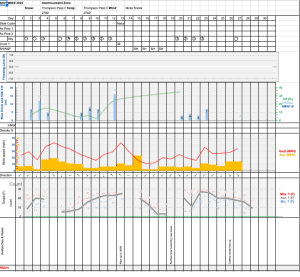
NWS Point forecast for Thompson Pass
Date               Saturday 12/31/22       Sunday 01/01/23
Time (LT)          06    12    18    00    06    12    18    00    06
Cloud Cover        OV    OV    OV    OV    OV    OV    OV    OV    OV
Cloud Cover (%)    80    90    85    95   100   100   100   100   100
Temperature        19    21    23    20    22    29    32    29    29
Max/Min Temp                   24          19          33          26
Wind Dir           SE    SE     E     E     E     E    SE    SE    SE
Wind (mph)          4    11    13    23    20    25    24    14    18
Wind Gust (mph)                      34    40
Precip Prob (%)    40    50    40    70    90   100   100   100    80
Precip Type         S     S     S     S     S     S     S     S     S
12 Hour QPF                  0.05        0.50        0.86        0.44
12 Hour Snow                  0.0         5.1         9.0         4.3
Snow Level (kft)  0.3   0.2   0.2   0.6   1.7   1.3   1.6   1.3   1.2
Click on link below for Thompson Pass weather history graph:
| Date:
12/31 |
24 hr snow | HN24W* | High temp | Low temp | 72 hour SWE* | December snowfall | Seasonal snowfall | Snowpack Depth |
| Valdez | N/O | N/O | 33 | 29 | N/O | 61 | 96 | 40 |
| Thompson pass | 2.5 | .05 | 26 | 14 | .15 | 94 | 194 | 26 |
| 46 mile | 0 | 0 | 17 | 11 | N/O | ~32 | ~36** | 31 |
*HN24W- 24 hour Snow water equivalent in inches
*SWE– Snow water equivalent
**46 mile seasonal snowfall total begins December 1st.
Additional Information
Click on the link below for a running summary of the seasons weather history.
Announcements
The avalanche hazard is moderate at all elevations. Human triggered avalanches are possible up to 1 foot in depth in wind loaded terrain. The hazard will increase if significant snowfall and warming temperatures arrive earlier than forecasted.
Posted by Gareth Brown 12/31 7:40 am.
For a description of current avalanche problems, weather information, season history and more click the (+ full forecast) button. Avalanche forecasts will be issued Wednesday-Sunday.