Valdez
Above 4,000ftConsiderable
2,000 to 4,000ftModerate
Below 2,000ftLow
Degrees of Avalanche Danger
Avalanche Problems
Problem 1
Snow has returned to the Valdez/ Thompson Pass region with heavier accumulations near the coast. Valdez has received _ and Thompson Pass has received _ in the last 48 hours. This new snow is falling on very hard, low friction (slick), wind damaged surfaces. Expect to find widespread instabilities near the coast where more snow fell. For the continental and intermountain zones instabilities will exist in specific areas. These areas include places were southerly storm winds have redistributed new snow into deeper slabs that may be reactive. Watch out for the lee side of high elevation ridge lines as well as cross loaded gullies and the lee side of terrain features.
Additional accumulation during the day Wednesday is expected to be light. During the afternoon moderate to strong north winds are expected to kick up which will add further stress to SE-NW aspects. Avoid slopes that have been previously loaded by storm wind as well as those being actively loaded by north winds.
Thin (weak) snowpacks can not handle the sudden changes that a strong (thick) midwinter snowpack can. As snow and weather conditions change expect to encounter areas of unstable snow.

Likelihood:
- Almost Certain
- Very Likely
- Likely
- Possible
- Unlikely
Size:
- Historic
- Very Large
- Large
- Small
Trend
- Increasing
- Steady
- Decreasing
Problem 2
There are multiple rain crusts from October that are faceting in the mid and lower snowpack. Recent winds have created very strong snow at the surface making it difficult for a person or machine to affect these deeper layers. New snow is adding stress to these layers, but at this point it is unlikely that we have received enough new snow to overcome the strong bridging affect of the wind damaged snow from late November that is near the surface. It is possible that smaller storm snow or wind slab avalanches could have enough force to step down to these deeper layers.
Affecting this avalanche problem is currently unlikely, but will likely become a problem later in the season once we begin to receive some significant snow.
There is a higher possibility of affecting these layers in the continental zone where a more faceted snowpack exists.

Likelihood:
- Almost Certain
- Very Likely
- Likely
- Possible
- Unlikely
Size:
- Historic
- Very Large
- Large
- Small
Trend
- Increasing
- Steady
- Decreasing
Avalanche Activity
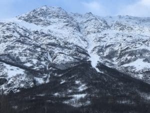
11/14- Debris from a D3 natural avalanche at snow slide gulch ended 100 vertical feet above the Lowe river.
Large avalanches (D2-2.5)also occurred in multiple other locations including Berlin Wall, Catchers Mitt, South Three Pigs and Billy Mitchell. The activity extends beyond this list, and mostly occurred during the peak of warming and precipitation on 11/13.
Multiple natural D1-1.5 avalanches were observed on multiple aspects at low elevation. No step downs noted.
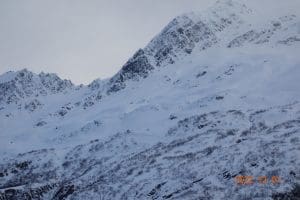
12/1- 2 D2.5 natural avalanches were noted on Three Pigs (Beaver slide, Pig Leg). Pig leg ran into the top 1/3 of the fan and Beaver Slide stopped near the end of its track. These both likely occurred during the outflow wind event 11/26-11/29.
D2 natural wind slab was observed on 40.5 mile peak on a west aspect ~3000′. Crown depth range estimated 1-2 feet and 200′ long
Weather
Check out our updated weather tab! A collection of local weather stations are available for viewing with graphs and tabular data included.
NWS Watches and warnings
None
NWS Point forecast for Thompson Pass
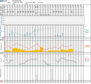
Date               Wednesday 12/07/22      Thursday 12/08/22
Time (LT)          06    12    18    00    06    12    18    00    06
Cloud Cover        OV    OV    OV    OV    OV    OV    BK    BK    BK
Cloud Cover (%)   100    95    95    90    75    75    60    65    65
Temperature        26    25    23    19    14    13    12    10    10
Max/Min Temp                   26          14          15           7
Wind Dir            E    NE     N     N     N     N     N    NE     N
Wind (mph)          8    12    29    33    31    32    28    26    16
Wind Gust (mph)    27    36    48    49    52    57    51    46    36
Precip Prob (%)    90    20    10    10    10    10    10    10    10
Precip Type         S     S
12 Hour QPF                  0.06        0.00        0.00        0.00
12 Hour Snow                  0.6         0.0         0.0         0.0
Snow Level (kft)  0.3   0.1   0.0   0.0   0.0   0.0   0.0   0.0   0.0
Click on link below for Thompson Pass weather history graph:
| Date:
12/7 |
24 hr snow | HN24W* | High temp | Low temp | 72 hour SWE* | December snowfall | Seasonal snowfall | Snowpack Depth |
| Valdez | 7 | .56 | 33 | 30 | .9 | 10 | 34 | 22 |
| Thonpson pass | 3.5 | .2 | 30 | 23 | .4 | 7 | 102 | 30 |
| 46 mile | 1 | .1 | 20 | 13 | .2 | 3 | 3** | 16 |
*HN24W- 24 hour Snow water equivalent in inches
*SWE– Snow water equivalent
**46 mile seasonal snowfall total begins December 1st.
Additional Information
Our snow season began with above average precipitation and temperatures. Beginning in September, snow lines generally hung around 4500′ until 10/12. At that point our area received the first snow down to sea level with 12-16 inches on the north side of Thompson Pass.
On 10/15 wet conditions continued with the freezing line rising to 5000′ or higher. As skies finally cleared on 10/22 we were left with a thin rain saturated snowpack capped by a stout rain crust up to 4500′. Above 4500′ much deeper snowpacks existed due to significant early season snowfall at upper elevations.
Dry and cold conditions along with moderate outflow winds finished out the month of October.
On 11/1 precipitation returned with 18 inches of snow and ~1″ of SWE on Thompson Pass. This new snow was initially reactive with several natural D2 avalanches reported on Thompson Pass. These slides were running on a firm bed surface consisting of old rain crusts and old wind slabs from October.
On 11/4 a strong north wind event kicked up with 65 mph+ winds on Thompson Pass. Our snowpack received significant damage as already thin snow below 4500′ was stripped down to old wind slabs, rain crusts and the ground.
Precipitation returned on 11/8 and became heavy on 11/11. Storm totals of around 50 inches were recorded at Thompson Pass DOT between 11/8-11/13. Snow lines rose to ~3000′ near the tail end of the storm with heavy rain occurring in low lying areas.
Skies cleared on 11/14 through 11/18 with a strong temperature inversion setting up. Valley temperatures north of Thompson Pass fell to 0° F with above freezing temperatures existing above 4000 feet. Valdez temps remained mild. This weather allowed for widespread surface hoar up to 1 cm to develop in low lying areas.
Precipitation returned on 11/19, with incremental snowfall on Thompson Pass and areas north. The Valdez area received rain during this period. 12 inches have been recorded at TP DOT between 11/9-11/23.
11/26-11/29- Strong outflow (N) wind event. Many areas below 3000′ were stripped to the 11/13 rain crust, destroying the 11/19 BSH layer. Widespread very hard snow surfaces were the result.
Precipitation returned to our area on 12/5, with higher accumulation amounts near the coast.
Announcements
The avalanche hazard is Considerable above 4000 feet and Moderate below for the Intermountain and Continental zones. Accumulations on Thompson Pass and north have been light (3-4 inches). Southerly winds have created deeper storm slabs up to 1 foot deep that were observed as reactive 12/5 on lee aspects. Human triggered avalanches will be likely up to 1 foot deep in specific areas. These areas include places where recent south winds have loaded new snow into deeper slabs especially on the lee side of high elevation ridge lines and cross loaded gullies.
Posted by Gareth Brown 12/7 8:00am.
For a description of avalanche problems, weather information, season history and more click the (+ full forecast) button. Avalanche forecasts will be issued Wednesday-Sunday.