Valdez
Above 4,000ftModerate
2,000 to 4,000ftModerate
Below 2,000ftModerate
Degrees of Avalanche Danger
Avalanche Problems
Problem 1
6 inches of uncohesive (no slab) snow was observed at 4000′ on 4/5 near The Books. Storm totals of 8-12 inches are expected by this evening as light precipitation continues. New snow instabilities may exist in the short term as new snow attempts to bond with the underlying snowpack. Light winds, and relatively mild temperatures at upper elevations (low 20’s) should promote bonding in the future. Today, sensitivity at the surface will largely depend upon the amount of wind the new snow has encountered. In many areas this new snow has not had time to develop a slab, instabilities will exist in specific areas. These include, steep convex terrain and areas where the new snow has been stiffened by wind. Pay attention to the depth and sensitivity of new snow in the area you choose to travel. Sensitivity can be assessed through small test slopes and hand shear tests. The hazard will be Considerable in areas where more than 12 inches of snow has fallen.

Likelihood:
- Almost Certain
- Very Likely
- Likely
- Possible
- Unlikely
Size:
- Historic
- Very Large
- Large
- Small
Trend
- Increasing
- Steady
- Decreasing
Problem 2
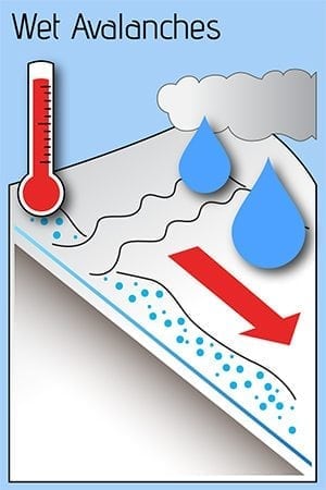
Wet loose avalanche activity is expected if the sun comes out later in the day. New snow will be easily affected by solar radiation making wet loose activity likely if the sun makes an appearance today.
Assesment and avoidance of this avalanche problem is relatively easy. Pay attention to the amount of warmth that is being transferred into the snow surface (Is it becoming moist-wet?). Avoid traveling on or being exposed to steep solar aspects where the surface snow is becoming moist-wet during the heat of the day.
Likelihood:
- Almost Certain
- Very Likely
- Likely
- Possible
- Unlikely
Size:
- Historic
- Very Large
- Large
- Small
Trend
- Increasing
- Steady
- Decreasing
Problem 3
Persistent weak layers in our snowpack have been dormant in our forecast area for ~10 days. The new snow we are currently receiving is unlikely to tip this balance. There is the potential for weak layers in our mid snowpack to reactivate later in the spring as solar radiation becomes more intense or if we enter a period where heavy precipitation returns. At the present instabilities are concentrated near the surface and triggering a persistent slab avalanche is unlikely.

Likelihood:
- Almost Certain
- Very Likely
- Likely
- Possible
- Unlikely
Size:
- Historic
- Very Large
- Large
- Small
Trend
- Increasing
- Steady
- Decreasing
Problem 4
Weak snow exists at the base of our snowpack. This weak snow is currently unlikely to be affected due to the strength of old wind affected snow at the 3/17 new/old interface. Depth hoar may become a concern later in the season if our area returns to a period of major snowfall and the very strong wind damaged layer at the new/old interface starts to break down and lose strength within the snowpack. As very hard wind slabs break down within the snowpack a person or machines weight will have a more direct affect on weak layers at the bottom of the snowpack. In addition, the increasing intensity of the sun will be putting pressure on deep layers during the heat of the day.

Likelihood:
- Almost Certain
- Very Likely
- Likely
- Possible
- Unlikely
Size:
- Historic
- Very Large
- Large
- Small
Trend
- Increasing
- Steady
- Decreasing
Avalanche Activity
Below is a summary of observed Avalanche activity from the last 7 days. Avalanches that were noted earlier in the season can be viewed by clicking the link below.
If you trigger or observe an avalanche consider leaving a public observation.
4/2- D1.5 skier triggered wind slab avalanche. NW aspect/~4000′.
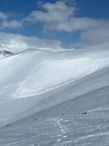
4/1- Multiple skier triggered D1 avalanches were reported on a variety of aspects. These were wind slabs in the 4-8 inch range.
3/31- Skier triggered avalanche reported at high elevation of the Maritime climate zone. This failed on surface hoar that was buried on 3/30. No skier involvement. Crown depth was 4-8 inches.
3/24- Ski cuts were reported as being productive, with avalanches up to D2 at the 3/21 interface.
3/18-21- Several D1-D2 human triggered avalanches have been reported. For the most part these have been outside our forecast zone and appear to be more likely in areas with either a weaker underlying snowpack (continental zone) or where storm totals were higher (SE of Thompson Pass). Remote triggers have also been reported as the Hamilton storm slab has settled and gained cohesion.
3/17- Multiple D1-D2 natural storm slab avalanches were reported and observed along the road corridor. These all failed within the storm snow with the exception of one deep persistent avalanche reported on Billy Mitchell.
Weather
Check out our updated weather tab! A collection of local weather stations are available for viewing with graphs and tabular data included.
NWS Watches, warnings and advisories
NONE
NWS Point forecast for Thompson Pass
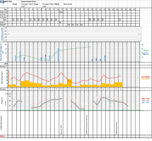
Date                     Thursday 04/06/23       Friday 04/07/23
Time (LT)          04    10    16    22    04    10    16    22    04
Cloud Cover        OV    OV    OV    SC    SC    SC    BK    OV    OV
Cloud Cover (%)   100   100    85    50    40    40    65    80    90
Temperature        24    26    30    23    18    21    27    23    20
Max/Min Temp                   30          18          28          18
Wind Dir           NE    SE    SW    SW     E    SE     S     S     E
Wind (mph)          4     2     8     2     3     5     9     6     3
Wind Gust (mph)
Precip Prob (%)    80    80    60    30    10    20    40    40    20
Precip Type         S     S     S     S           S     S     S     S
12 Hour QPF                  0.13        0.04        0.02        0.04
12 Hour Snow                  1.5         0.1         0.0         0.0
Snow Level (kft)  0.0   0.2   0.2   0.0   0.0   0.0   0.0   0.0   0.0
Click on link below for Thompson Pass weather history graph:
| Date:
04/06 |
24 hr snow | HN24W* | High temp | Low temp | 72 hour SWE* | April snowfall | Seasonal snowfall | Snowpack Depth |
| Valdez | Trace | .1 | 42 | 30 | 0 | 0 | 239 | 48 |
| Thompson Pass | ~3 | N/O | N/O | N/O | 0 | 0 | 428 | N/O |
| 46 mile | Trace | 0 | 37 | 24 | 0 | 0 | ~115** | 54 |
*HN24W- 24 hour Snow water equivalent in inches
*SWE– Snow water equivalent
**46 mile seasonal snowfall total begins December 1st.
Additional Information
Click on the link below for a running summary of the seasons weather history.
Announcements
The avalanche hazard is moderate at all elevations. Shallow storm slabs 6-10 inches in depth are developing at upper elevations . These may be reactive to human triggers in areas where this new snow has been loaded by wind. Watch for signs of instability at the surface including shooting cracks, collapsing and avalanche activity.
Posted by Gareth Brown 04/06 8:00 am.
For a description of current avalanche problems, weather information, season history and more click the (+ full forecast) button. Avalanche forecasts will be issued Wednesday-Sunday.
If you have pictures of recent natural or human triggered avalanches or notice signs of instability such as shooting cracks or collapsing, leave an observation to help improve forecast accuracy.