Valdez
Above 4,000ftLow
2,000 to 4,000ftLow
Below 2,000ftLow
Degrees of Avalanche Danger
Avalanche Problems
Problem 1
Thompson Pass has only received a couple inches of snow in the last 14 days, this drought alongside strong north winds have left us with a heavily wind damaged upper snowpack and good stability. Very hard (pencil-knife) wind slabs exist on the lee side of high elevation ridges and cross loaded gullies(SE-NW). Windward aspects have been stripped down to older layers of the snowpack , with sastrugi present and in some places the ground. Triggering an old wind slab avalanche near the surface is currently unlikely. On 3/14 these wind slabs were found to be unreactive to triggers while traveling on slope and in stability tests.
Small facets have been forming at the surface as winds have decreased and temperatures have remained below average. These facets exist atop a generally wind damaged snow surface that varies from wavy sastrugi on windward slopes to very hard smooth wind slabs in cross loaded gullies and top loaded slopes. The facets mentioned above will act as a weak layer in the future as we receive new snow. The wind damaged snow will act as an effective bed surface. Where previous wind slabs are present in cross loaded gullies and top loaded slopes, a low friction bed surface will exist. This is expected to be more sensitive once storm slabs begin to form tonight, than areas where sastrugi previously existed. Although poor bonding is initially expected on all varieties of wind affected snow. Storm slabs have not yet begun to form in our forecast area, and the hazard remains Low.
Other persistent interfaces exist in the mid snowpack. At this time, it is unlikely to affect these layers due very strong snow at the surface that is limiting the affect a person or machine would have on layers lower down in the snowpack. Remember that unlikely does not mean impossible, maintaining safe travel protocols is recommended.

Likelihood:
- Almost Certain
- Very Likely
- Likely
- Possible
- Unlikely
Size:
- Historic
- Very Large
- Large
- Small
Trend
- Increasing
- Steady
- Decreasing
Problem 2
Thompson Pass has received 11 inches of snow in the last 25 days. Recent outflow winds have stripped many areas, which has led to an overall decrease in the mass of our snowpack. Some areas did see depositions add to the depth of the pack, but the strength of winds we received has done more scouring, stripping and sublimating than redistributing and depositing.
The overall snowpack has become thinner over the last 2 weeks in most locations. Depth hoar is now closer to the surface and may increase the possibility to see full depth avalanches once significant loading events occur in the future, or the suns energy is able to penetrate deeper into the snowpack on south aspects. Another affect of depth hoar being closer to the surface is that these grains that were rounded in many locations are moving toward faceting again as temperature gradients increase. This has been confirmed by snow pits in all three forecast zones over the last week. These have shown the overall snowpack to be faceting at all levels, with the most significant affects occurring in the bottom 1/3. Currently, affecting this layer remains unlikely. Although, may become an issue later in the season especially once the weather pattern changes and heavy snowfall returns.

Likelihood:
- Almost Certain
- Very Likely
- Likely
- Possible
- Unlikely
Size:
- Historic
- Very Large
- Large
- Small
Trend
- Increasing
- Steady
- Decreasing
Avalanche Activity
Below is a summary of observed Avalanche activity from the last 7 days. Avalanches that were noted earlier in the season can be viewed by clicking the link below.
If you trigger or observe an avalanche consider leaving a public observation.
No natural or human triggered avalanches have been reported or observed the last 7 days. Last activity observed occurred on the 7th and 8th during a strong temperature inversion that brought above freezing temperatures to mid and upper elevations for an extended period. Strong north winds on 3/9-10 may have produced some small avalanches, although none have been reported or observed.
Weather
Check out our updated weather tab! A collection of local weather stations are available for viewing with graphs and tabular data included.
NWS Watches and warnings
NONE
NWS Point forecast for Thompson Pass
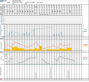
Date               Thursday 03/16/23       Friday 03/17/23
Time (LT)          06    12    18    00    06    12    18    00    06
Cloud Cover        OV    OV    OV    OV    OV    OV    OV    OV    OV
Cloud Cover (%)    80   100    90    90   100   100   100    85   100
Temperature         9    16    19    16    16    22    27    24    21
Max/Min Temp                   22          12          30          19
Wind Dir           NE     E    SE     E    NE     E     E     E     E
Wind (mph)          8     8     5     6    16    12    24    18    14
Wind Gust (mph)                                  43    54    40    35
Precip Prob (%)    60    80    80    60   100   100    80    60    90
Precip Type         S     S     S     S     S     S     S     S     S
12 Hour QPF                  0.13        0.34        0.53        0.31
12 Hour Snow                  2.3         5.7         8.4         3.2
Snow Level (kft)  0.0   0.0   0.0   0.0   0.0   0.4   1.0   0.5   0.2
Click on link below for Thompson Pass weather history graph:
| Date:
03/16 |
24 hr snow | HN24W* | High temp | Low temp | 72 hour SWE* | March snowfall | Seasonal snowfall | Snowpack Depth |
| Valdez | 0 | 0 | 26 | 14 | 0 | 2 | 218 | 48 |
| Thompson Pass | 1 | 0 | 14 | 2 | N/O | 7 | 375 | 32 |
| 46 mile | 0 | 0 | 20 | 2 | 0 | 1 | ~85** | 41 |
*HN24W- 24 hour Snow water equivalent in inches
*SWE– Snow water equivalent
**46 mile seasonal snowfall total begins December 1st.
Additional Information
Click on the link below for a running summary of the seasons weather history.
Announcements
The avalanche hazard is Low at all elevations. Human triggered avalanches are unlikely. Today will be the last day of low hazard before a Pacific storm is forecasted to deliver 12-18 inches of snow for Thompson Pass. Snowfall is expected to slowly begin this afternoon and become heavy by tonight. The hazard will move to moderate if heavy snowfall arrives earlier than forecasted.
Posted by Gareth Brown 03/16 8:00 am.
For a description of current avalanche problems, weather information, season history and more click the (+ full forecast) button. Avalanche forecasts will be issued Wednesday-Sunday.
If you have pictures of recent natural or human triggered avalanches or notice signs of instability such as shooting cracks or collapsing, leave an observation to help improve forecast accuracy.