Haines Avalanche Center
Above 2,500ftConsiderable
1,500 to 2,500ftConsiderable
Below 1,500ftModerate
Degrees of Avalanche Danger
Avalanche Problems
Problem 1
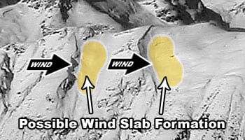
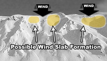
Aspect: Most likely on wind loaded aspects and features SW-S-SE-E.
Elevation: Mainly at and above treeline.
The Bottom Line: NW winds have increase this weekend. Watch out for new wind loading and avoid freshly loaded slopes. Look for signs of sensitive surface slab conditions including natural avalanche activity, shooting cracks and whumphing or collapsing. In specific areas wind slab could be layered over surface hoar and old weak surface snow – that is prime for human triggering.
Travel advice: Avoid wind loaded aspects at and above treeline. Look for visual clues such as active wind loading and blowing snow. Stay away from slopes below ridgelines, roll-overs, or cross loaded gullies and other features steep enough to slide >30 degrees. Beware of fresh cornices that have formed from the wind and are brittle due to decreasing temperatures. Avoid terrain traps where snow could pile up quickly, or the consequences of a slide could cause injury or death.
Note: Surface avalanches could step down to weaker buried layers, see Persistent Slab problem.

Likelihood:
- Almost Certain
- Very Likely
- Likely
- Possible
- Unlikely
Size:
- Historic
- Very Large
- Large
- Small
Trend
- Increasing
- Steady
- Decreasing
Problem 2
Aspect: All aspects.
Elevation: All elevations, mainly at and above treeline.
The Bottom Line: Weak layers exist in our snowpack, buried between and beneath various wind slabs. Continued cold temps are preserving these weak layers. These weak layers exists on specific terrain features with common characteristics, but not always obvious. They could be difficult to trigger by a person, but could have wide propagation. Identify and avoid features of concern, such as thin areas and possible trigger point. Evaluate snow and terrain carefully.
Travel advice: Use safe travel techniques such as only exposing one person at a time both on the way up and down. Identify and avoid thin areas where weak layers are more likely to trigger a slide from. Group up in safe zones that are out of harms way. Have good communication, including radios and a set plan in case of an emergency. Be practiced at companion rescue.
You can find safer conditions in wind-protected areas with softer snow. The persistent slab danger is not going away, it is standing by waiting for the right trigger. We have not had a crush and flush cycle, or stabilizing event. Keep in mind that most avalanches are triggered by someone in the group.
- Near recent observations from Old Faithful found a thin crust with weak snow down 60-70cm near 3,200′ and below
- This bathtub ring effect, from lower-elevations to mid-elevation, where freezing levels are more likely to cause crusts and weak layers – should be carefully evaluated.
- Weaker snow (buried facets) forming between wind slabs in the top of the pack
It is still possible that any surface avalanches could step down to deeper weak layers, the October rain crust, or even the ground in alpine areas.
***We should also should pay close attention to what is happening on the surface, keep an eye out for surface hoar and weak sugary snow. Extended cold, clear conditions in areas with light winds and higher humidity is not a good recipe for stable snow from the next storm. Stay tuned…. ***

Likelihood:
- Almost Certain
- Very Likely
- Likely
- Possible
- Unlikely
Size:
- Historic
- Very Large
- Large
- Small
Trend
- Increasing
- Steady
- Decreasing
Avalanche Activity
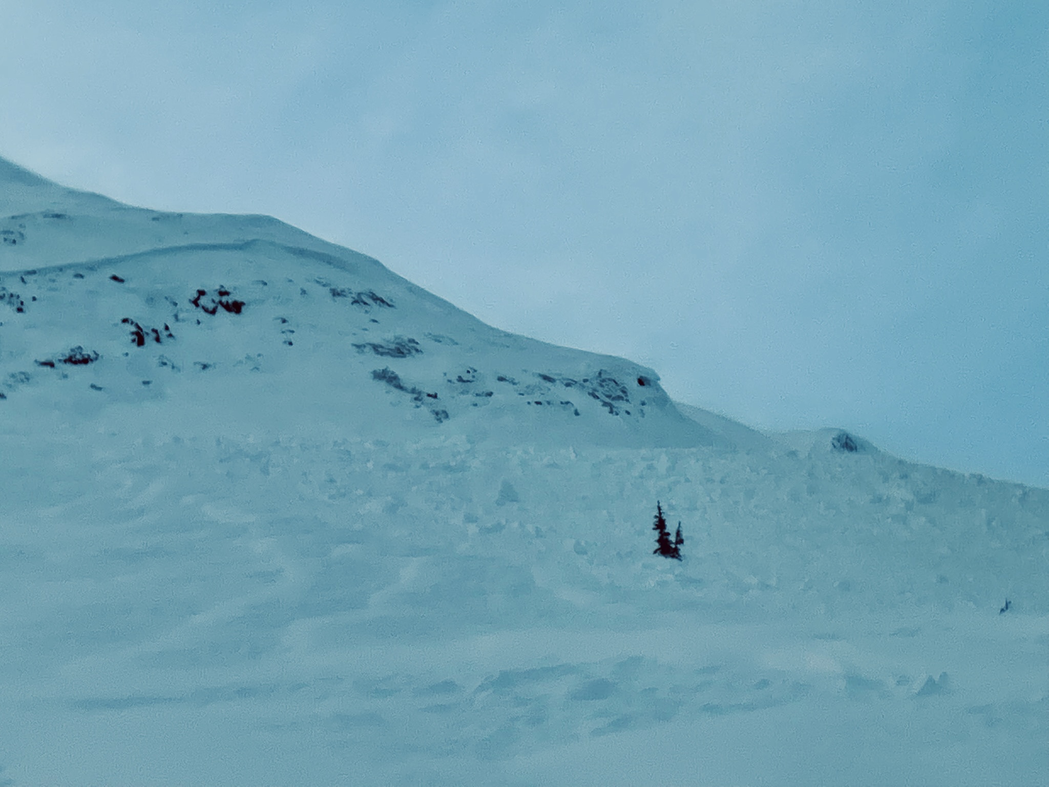
This natural avalanche occurred on Dec 12th on Old Faithful during the recent wind event. It ran on a cross-loaded NE aspect at 3200ft, running on the October rain crust. It shows that given a heavy new load, this persistent weak layer can activate and cause a large avalanche.
Weather
Temperatures are starting to fall again, and we expect to remain in very cold, mostly clear conditions for the next several days. NW winds have increased as well, and wind chills could be brutal (-30 ish).
- Moderate NW winds hit the slopes Dec 19-20th
- Surface hoar formed on all aspects and elevations Dec 17-18th.
- A strong NW wind event on Dec. 11-14, caused active wind loading
- Early December has brought in about 2-4 feet of snowfall
- November brought consistent heavy snowfalls, cold weather, and SE winds
- October brought heavy snow in the alpine, followed by a few rain/sun crusts
| Snow Depth [in] | Last 24-hr Snow/SWE [in] | Last 3-days Snow/SWE [in] | Today’s Freezing Level [ft] | Today’s Winds | Next 24-hr Snow/SWE | |
| Mount Ripinsky @ treeline ** | 61″* | 0″ / 0.0* | 0″ / 0.00* | 0′ | mod, NW | 0″ / 0.0* |
| Flower Mountain @ treeline | 44″ | 0″ / 0.00 | 0″ / 0.00* | 0′ | mod, NW | 0″ / 0.00* |
| Chilkat Pass @ 3,100ft | 19″ | 0″ / 0.00 | 0″ / 0.00* | 0′ | mod, NW | 0″ / 0.00* |
( *star means meteorological estimate )
** The Ripinsky weather station is in need of repair, and will likely be down until Summer.
Additional Information
Be prepared for an emergency and hypothermia. Winter is a high consequence environment. Carry bear spray.
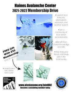
Become a sustaining Haines Avalanche Center Member by clicking the poster or visiting alaskasnow.org/joinHAC. Support local forecasts, observations, education and weather stations. Join a community of winter recreationalists. Benefit from collective knowledge and skills. Help keep your friends and family safe in the backcountry. Get a free limited edition mountain buff, or neck gaiter with a $50 membership (first 20 members!).
Practice like you play. Make sure all your rescue gear is fully functional and your beacon has NEW batteries. Make sure 1) everyone in the group has a functioning beacon, shovel and probe 2) knows how to use them and 3) has trained in companion rescue in the last year. Keep your skills fresh. If you head into the hills, watch out for red flag avalanche conditions, natural avalanches, whoomphing or collapsing, and shooting cracks.
Education Video Links:
- AIARE
- How to Practice Avalanche Rescue Snowmobile Edition: https://youtu.be/2ML499MMDfM
- AK Sled Shed Motorized Learning:
- Intro: https://youtu.be/aoagKHfGkxs
- Personal Electronics in Avalanche Terrain: https://youtu.be/2Vz9S0OEyFk
- Snowmobile Macgyver Tool Kit: https://youtu.be/4WBNu_t6Bbk
- Head and Face Protection: https://youtu.be/jIzW89wOyZI
- Pre-season prep: https://youtu.be/zJmrb8cZlR4
- My Transceiver: https://youtu.be/yblaDWP7Jf8
- BCA Avalanche Safety for Snowmobilers
- How to Fix Common Snowmobile Problems in the Field: https://youtu.be/g9fiTxEvuFk
- Sleducation: Avalanche Safety for Snowmobilers: https://youtu.be/EWFOd_9DYb8
- Intro to Avalanche Transceivers for Snowmobilers: https://youtu.be/6ZLSBmsceog
- Avalanche Transceiver Trailhead Test for Snowmobilers: https://youtu.be/rWoXbadFBsY
- Avalanche Transceiver Searching Use Snowmobiles: https://youtu.be/w1ucyI6LMXM
- BCA Avalanche Rescue Series
- Beacon Search 101: https://youtu.be/nnHXLVA2FcE
- Avalanche Probing 101: https://youtu.be/-0_yDN5Drzw
- Avalanche Shoveling 101: https://youtu.be/dGQg9o3vAkM
- Organizing a Backcountry Rescue: https://youtu.be/gywtmukgt8s
- Post Avalanche Patient Care: https://youtu.be/9FyIeUy4wpQ
- Backcountry Evacuation: https://youtu.be/WPF-dciefL8
- Complex Multiple Burials Backup Techniques: https://youtu.be/pB6AfY2KyYo
- National Avalanche Center
- Avalanche Problems Explained: https://youtu.be/DkbnT_9-cHU
- Intro to North American Avalanche Danger Scale: https://youtu.be/r_-KpOu7tbA
Announcements
Bottom Line: NW winds have increased this weekend. Watch out for new wind loading! Weak layers exist in our snowpack, buried between and beneath various old wind slabs. Identify and avoid features of concern, such as thin areas and possible trigger point.Click the –Full Forecast– button below for more details. Please submit your observations!