Haines Avalanche Center
Above 2,500ftModerate
1,500 to 2,500ftModerate
Below 1,500ftLow
Degrees of Avalanche Danger
Avalanche Problems
Problem 1
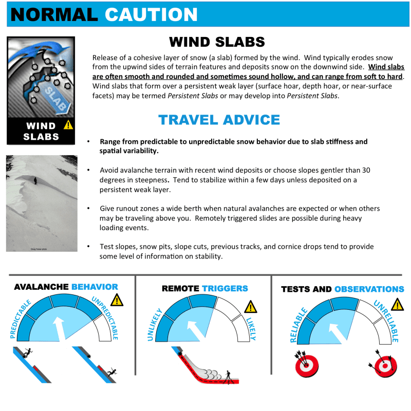
The Bottom Lin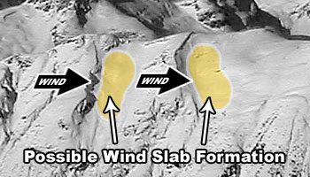 e: Our snowpack was rocked this week with 5 inches of new precipitation (3-5 feet of new snow in the high alpine), with strong drifting and scouring from the SE. The rain line reached up to 4,000ft Wednesday, but temperatures are dropping and the snow surface is settling and freezing. You are likely to encounter recent wind slabs in the alpine, and they may be sensitive in steep, wind loaded areas. Look for recent avalanches, try to assess how deep they ran, and be sure to avoid similar slopes.
Never expose more than one person at a time to slopes 30-degrees and steeper. Don’t enter avalanche terrain without a plan for how to manage an avalanche that could break far wider and larger than you expect. If a surface wind slab were to let loose, it could possibly step down to deeper weak layers.

Likelihood:
- Almost Certain
- Very Likely
- Likely
- Possible
- Unlikely
Size:
- Historic
- Very Large
- Large
- Small
Trend
- Increasing
- Steady
- Decreasing
Problem 2
We should remain aware that very deep and wide destructive avalanches need to be considered and planned for accordingly. Pay attention to run-out paths and leave wide margins of safety for larger than expected slides. Terrain management is critical. An avalanche in the upper snowpack or cornice failures could step down and lead to a massive avalanche.
Think about the connectedness of a hard slab, from where you are standing. If something is triggered on a steep slope or in a thin area nearby, does that slab connect to you, or above you? What about the rest of your group?
Old Melt Layers and Crusts:
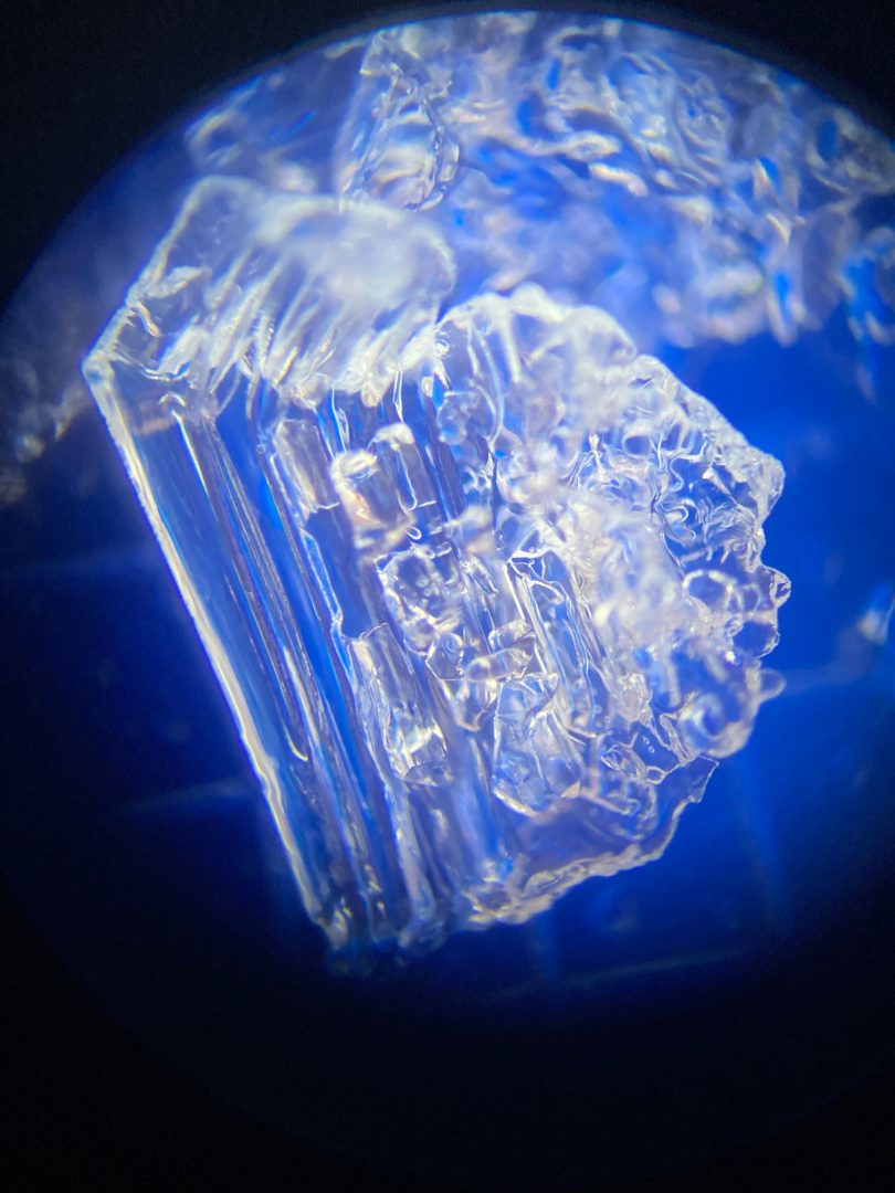
- A buried persistent weak layer about 6+ feet deep (The “Big Warmup” Layer, Formed Nov 17th) is still a concern.
- It is a thick refrozen crust with weak faceted snow above. This is an unusual and unpredictable weak layer because it formed during a thaw event and then re-froze while cold temperatures faceted the stout crystals.
- A wide safety margin is necessary. This setup could produce avalanches that break wider than expected, and are most likely to be triggered from shallow trigger points like rocks or small trees. You could ride the same slope numerous times until that right spot produces a large destructive slide.
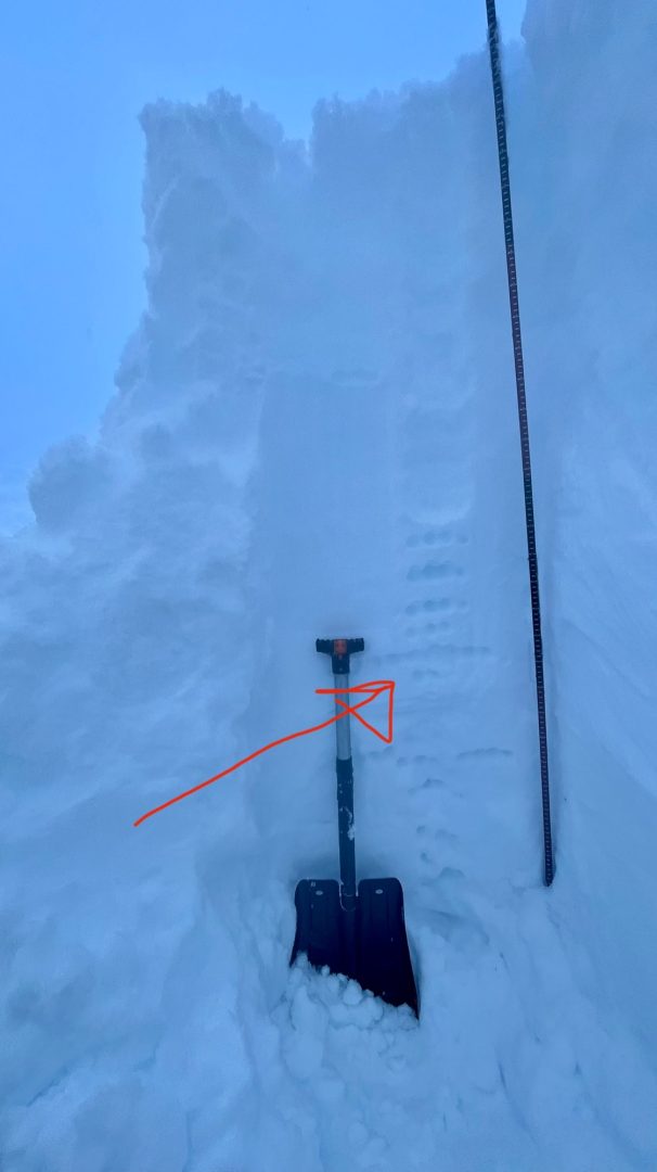
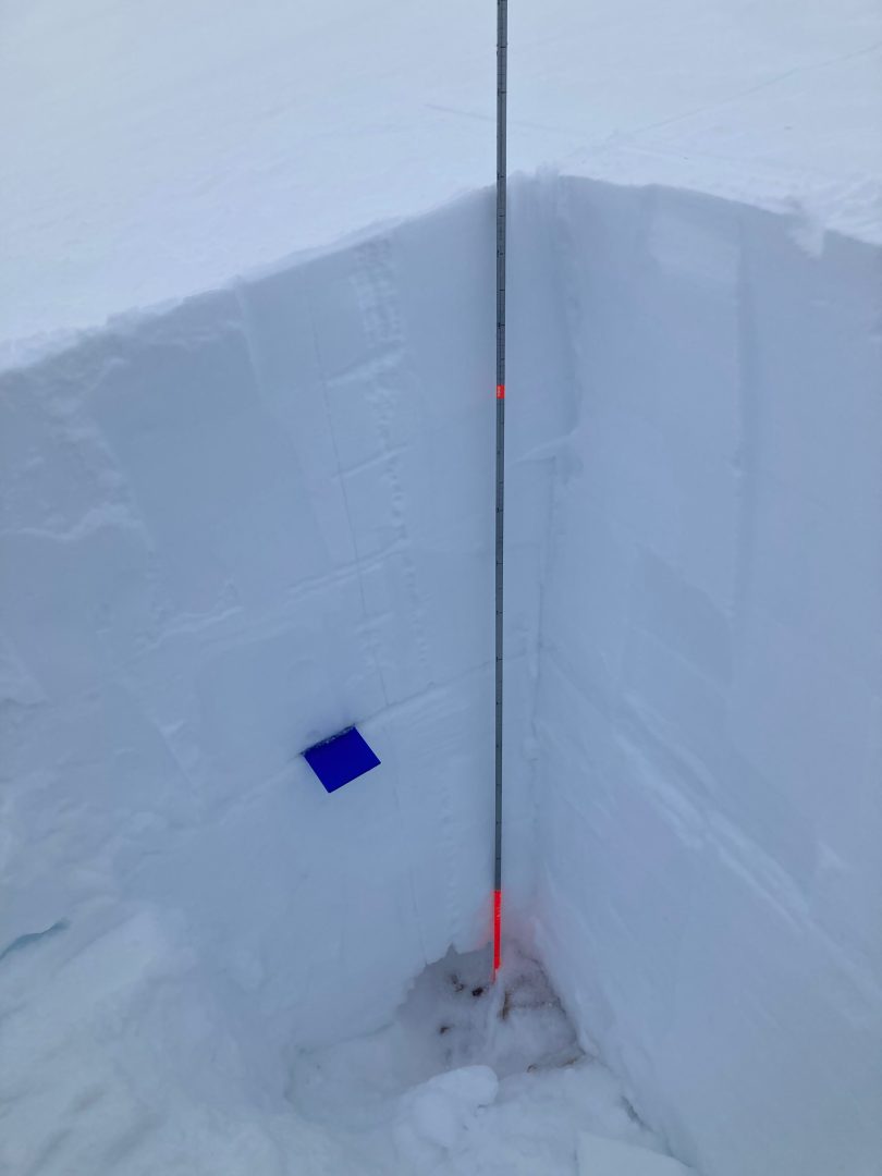
Photos of the “Big Warmup” facet layer in the Transitional Zone at 2500ft on 1/2 with test results ECTP18 that demonstrated propagation potential on this layer. And a photo from Old Faithful on 1/12 of a 5″ thick layer of facets down 170cm.
Observations in all zones throughout December and now into January have found moderate strength and quick propagation on failures within the “Big Warmup” crust/facet layer. We know it to exist at all elevations above 1000ft — even up to the highest summits. We expect this layer (and other midpack crust-facet layers) to be an ongoing issue going forward.
Depth Hoar at the Ground (Above 3,000′):
- October snow followed by long cold snaps created depth hoar at the ground in most areas. These angular snow grains are well developed into a weak layer that behaves like brittle glass.
- As the snow gets deeper, the load over this layer increases, and it could collapse. You are most likely to human-trigger this layer from shallow spots around rocks, or trees, or have a surface avalanche step down to the ground on this layer. Any slides that break to the ground are likely to be deadly.
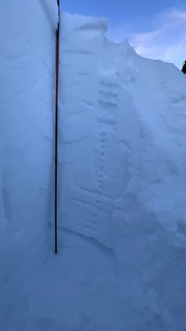
Photos shows 6-9mm advanced depth hoar at the ground down 180cm with ECTP 25 down 80cm on facets below a crust in the Haines Pass Zone at 4,000ft on a NE-aspect.

Likelihood:
- Almost Certain
- Very Likely
- Likely
- Possible
- Unlikely
Size:
- Historic
- Very Large
- Large
- Small
Trend
- Increasing
- Steady
- Decreasing
Problem 3
Below 3000ft:
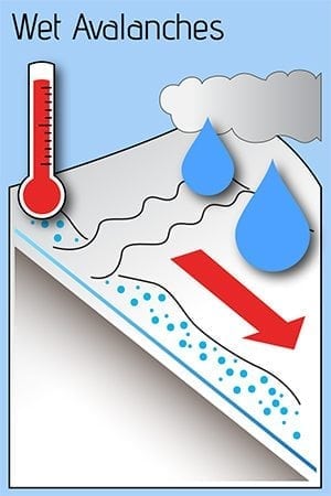
Lingering water in the snowpack may keep wet slides possible in middle elevations today. You can avoid this danger by sticking to slopes less than 30 degrees, and staying out of gullies and terrain traps that funnel snow from above. Steep slopes (40 degrees and steeper) will be especially prone to large wet loose or wet slabs. This danger will linger until temperatures drop enough to freeze the upper snowpack in place.
Likelihood:
- Almost Certain
- Very Likely
- Likely
- Possible
- Unlikely
Size:
- Historic
- Very Large
- Large
- Small
Trend
- Increasing
- Steady
- Decreasing
Avalanche Activity
This week:
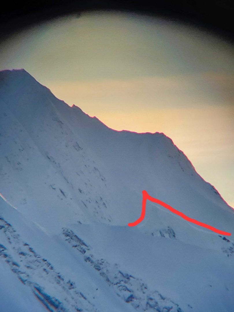
D2 N aspect 4300ft sub bowl of Old Faithful failed down to near ground, Was confined to a smaller pocket.
D3 on SW aspect at Lutak Inlet, ran down to the water
Over the last 3 weeks:
 In the Haines Pass, D2 N aspect ~5000ft natural slide, cornice fell and triggered slide- looked recent, failed mid second week of January. D1 W aspect ~5500ft, piece of cornice fell and triggered small slide/ sluff, potentially remotely triggered by a group.
A few natural deep slabs ran during a short period of warm weather in the Lutak zone. These isolated slides were D3+ sized, running 3-9ft deep and stepped down to the ground in spots. The largest ran on an unsupported slope above cliffs. Takhin ridge (E aspect around 3000ft) had several D2-D3 natural avalanches observed that ran about 2ft deep with very wide and complete propagation. This was in a protected basin where Surface Hoar likely grew before the last storm.
Weather
Forecast:
Friday-Sunday looks beautiful, with clearing skies, temperatures in the 20’s, and light NW winds increasing to moderate on Saturday. The next snowfall is likely early next week.
Recent Weather Summary:
- Jan 17-26 brought around 5″ of precip (3-5feet of new snow above 3000ft), strong SE winds, and a noticeable warmup
- Surface Hoar and Near Surface Facet growth Jan 8-10
- A strong front brought 24-30″ of snow above 2000ft on Jan 2nd.
- There was widespread Surface Hoar growth on Dec 31st.
- Dec 23-26 brought 10-18″ of new snow and a sharp rise in temperatures from -10F to 30F along with variable winds
- Dec 16-23 brought strong NW winds and arctic cold temperatures
- Dec 15 brought warmth/light rain up to 2600ft
- Complete Season Histories: Transitional Zone Lutak Zone
| Snow Depth | Last 24-hr Snow/SWE | Last 3-days Snow/SWE | Today’s Freezing Level | Today’s Winds | Next 24-hr Snow/SWE | |
| Mount Ripinsky @ 2,500′ | 92″ | 0″ / 0.15 | 0″ / 0.70″ | 500′ | light, NW | 0″ / 0.00″ |
| Flower Mountain @ 2,500′ | 57″ | 1″ / 0.10″ | 4″ / 0.30″ | 200′ | light, NW | 0″ / 0.00″ |
| Chilkat Pass @ 3,100ft | 40″ | 1″ / 0.10″ | 4″ / 0.30″ | 0′ | light, NW | 0″ / 0.00″ |
Additional Information
WEAR A HELMET! Be careful of rocks and hidden hazards. Be prepared for crevasses when on a glacier.
Are your riding companions trained and practiced in avalanche rescue? Everyone in your group needs to have a beacon, shovel, and probe, and know how to use them. Our mountains have very limited cell coverage, carry an emergency communication device and enough gear to spend the night.
Announcements
Click the +Full Forecast link below for each zone to read more. If you see any recent natural avalanche activity, or debris please submit an observation.