Haines Avalanche Center
Above 2,500ftHigh
1,500 to 2,500ftHigh
Below 1,500ftHigh
Degrees of Avalanche Danger
Avalanche Problems
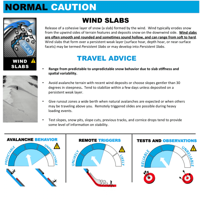
Problem 1
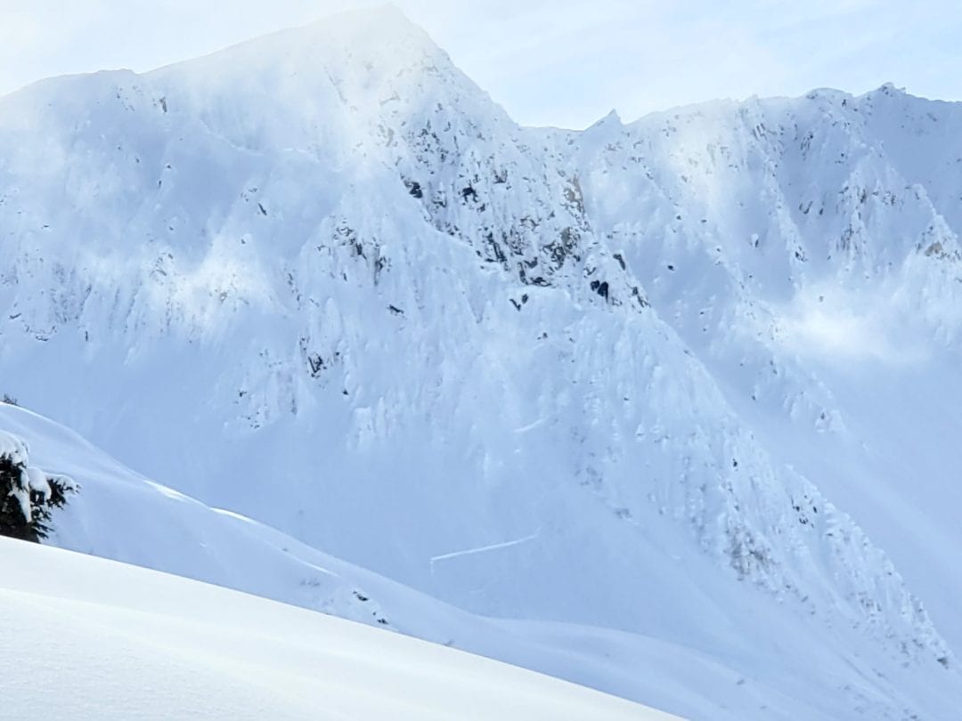
Three recent wind loading events:
- NW 20-25 mph winds March 7th – March 9th
- E-SE 10-20 mph winds March 10th (reverse loading event)
- NW 25-35 mph March 12th – 13th
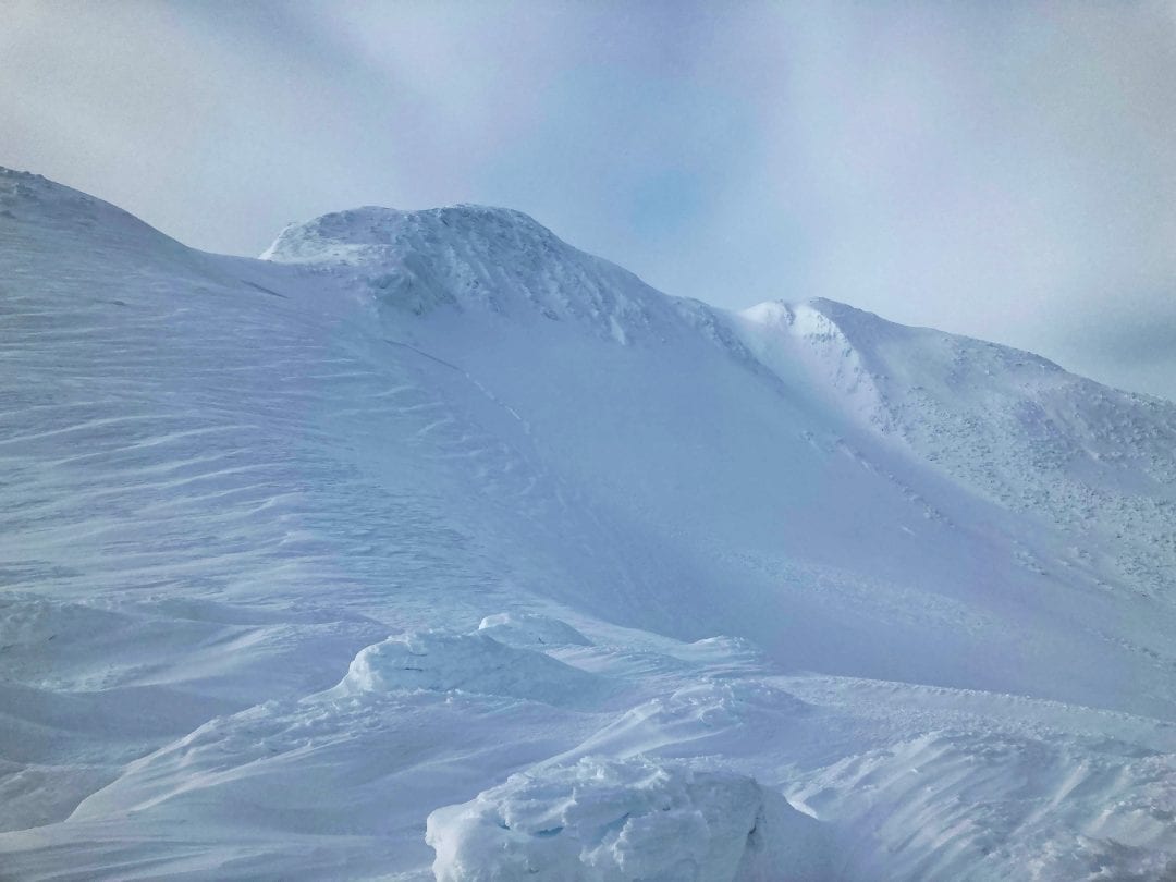
Wind slab has formed over last weekends near-surface facets and surface hoar near and above treeline on all aspects and will remain reactive for human triggering. March 11th – March 12th storm totals were 20-70cm. Accumulations were lower closer to town and higher further up valley and near the glaciers. The Haines Pass Weather Station reported 20cm or 7″ of wind transport over 24-hrs. Remember snow can be distributed 10 times faster than it can fall from the sky, expect very large spatial distribution and depth.
- Identify and avoid suspect wind loaded slopes
- Most likely to trigger a slab from a shallow part of the slope
- Look at the full avalanche path, identify starting zones
- These surface instabilities are over deeper buried PWL‘s
- Increased wind slab hazard adds overall complexity
- Use extra caution traveling below run-out zones

Likelihood:
- Almost Certain
- Very Likely
- Likely
- Possible
- Unlikely
Size:
- Historic
- Very Large
- Large
- Small
Trend
- Increasing
- Steady
- Decreasing
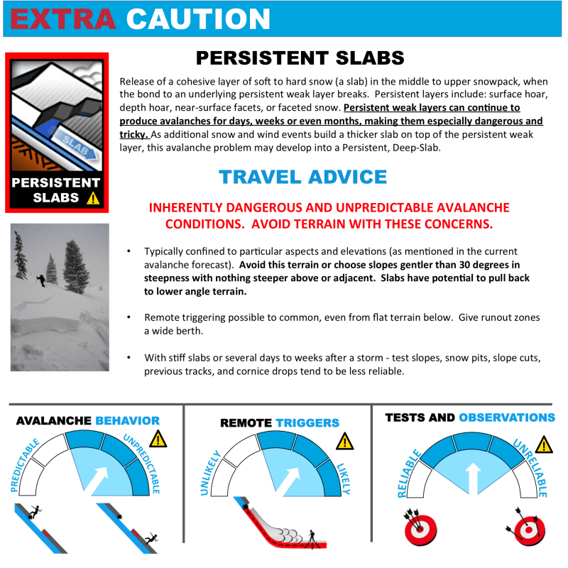
Problem 2
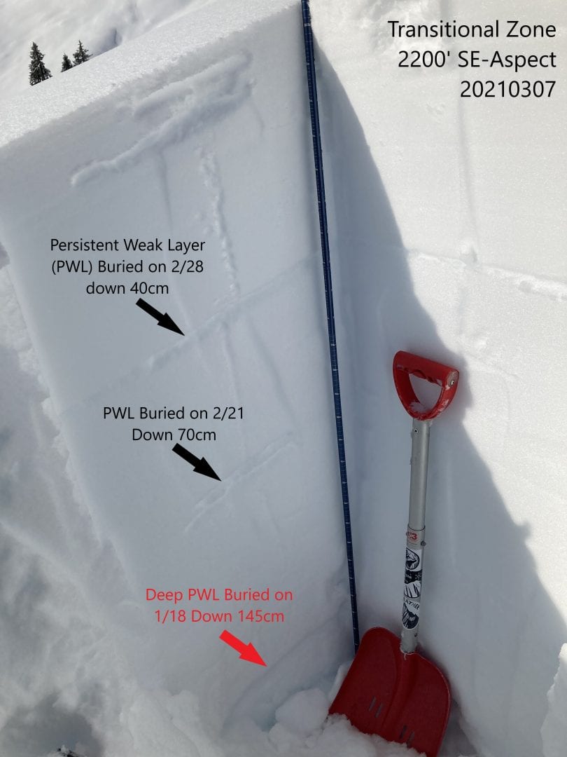
Three buried persistent weak layers:
- Near-surface facets (NSF) & surface hoar down 20-70cm March 11th
- Buried surface hoar & melt-freeze crust facet combo down 80cm February 28th
- Melt-freeze crust or facet combo down 110cm February 21st
Persistent weak layers below wind slab closer to the surface will be reactive or touchy for human triggered avalanches. Persistent layers in the mid-pack likely are to behave stubbornly, or unreactive. These heavy hard slabs sit over a series of buried surface hoar and facets/crusts from February 21 & 28. March 6th and 7th was significant weather due to warm temperatures which produced settlement. Temperatures March 6th at Flower Mountain SNOTEL 2500′ were 37F and dropped almost 20 degrees in a 3-day period.
- The location of these weak layers are difficult to map and highly elevation and aspect dependent.
- Glacier effect and valley effect are two contributing factors to where surface hoar has developed
- Freezing levels have shaped where hard crusts and facets combinations have formed.
- Sheltered terrain equal protected areas where weak layers are buried.
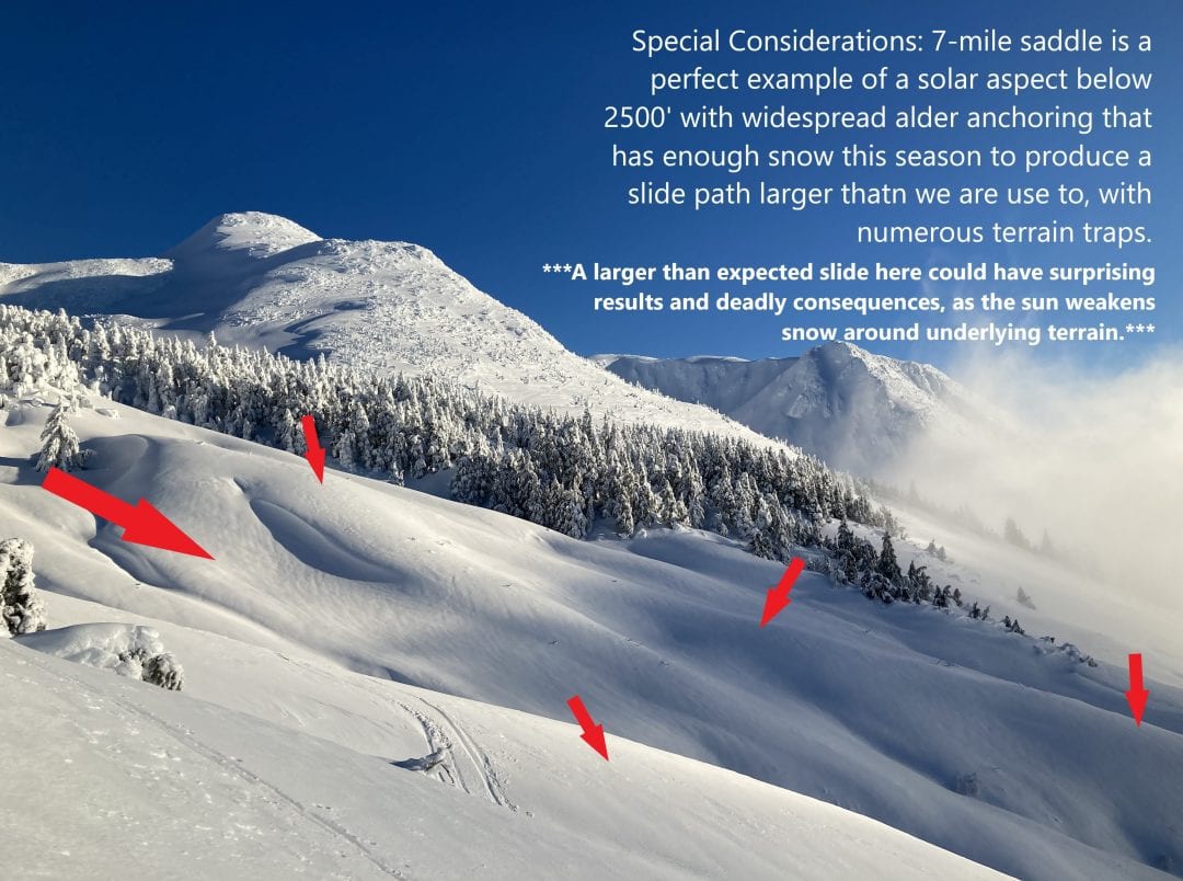
- Solar aspects are warming in the spring sun and have especially poor structure.
- Consider underlying terrain such as alder, trees, rocks, and cliffs suspect trigger points.
- Bigger triggers such as cornice collapse, snowmachine drops, or accessing thin areas of the slab.
- Sunlight weakens surrounding snow and those are areas you more likely could trigger an avalanche from.
What’s the tipping point? When will we wake up and see natural avalanches everywhere? Let it heal and do it’s thing. The layers are out there and they’re stressed. You can tickle it, but that could be that last little bit to tip the scales. According to the graph below, we currently are in the highest uncertainty about triggering an avalanche and can’t make easy decisions.While you may be able to “thread the needle” and find slopes with good stability, this continues to be a difficult task and the stakes are quite high.
- Slope angle is as important as ever when traveling through avalanche terrain, as well as slope failure consequences like terrain traps or group spacing.
- Only expose one person to a slope at a time and carefully identify run-out zones, starting zones, defined paths and non-defined paths.
- Beware of the familiarity heuristics “this slope never slides” as the snowpack is not giving us positive feedback for getting lucky.
- Expect avalanches to break bigger and run longer than expected, keep your safety margins very wide.
- More recent surface hoar and NSF’s from 3/7 & 3/8 has been buried by wind transport and reverse loading, as winds this past week switched from South to North (See Wind Slab above).
- Look for slopes that are below 30 degrees without steeper slopes connected above, or where tree spacing and anchoring it tight enough to avoid this avalanche problem.
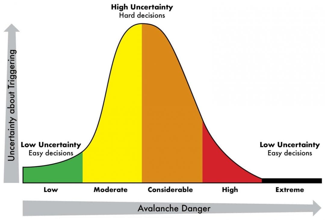
Image and wisdom is from IFMGA Guide Joe Stock’s Website https://www.stockalpine.com/posts/.

Likelihood:
- Almost Certain
- Very Likely
- Likely
- Possible
- Unlikely
Size:
- Historic
- Very Large
- Large
- Small
Trend
- Increasing
- Steady
- Decreasing
Problem 3
Two deep persistent weak layers:
- MLK day facet crust/combo down ~200cm buried on 1/18 is widespread on terrain near and below 3000′.
- November depth hoar down ~400cm in specific very steep, exposed, high alpine terrain.
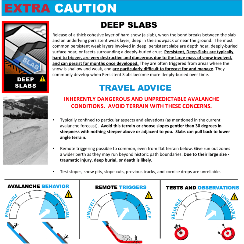
Deep Slabs require either a heavy trigger, like cornice falls and snowmachine drops. Or an avalanche in the upper layers of the snowpack that steps-down. You are also more likely to initiate a fracture from the thinnest part of the slope into a much thicker part. Think about how wind distributes snow to thin and fat zones.
These deep weak layers have been unreactive, or very stubborn but do exist in the landscape. Continued load such as settlement, wind, new snow, rain, or rapid temperatures changes will increase the hazard. Any slabs that break 1m+ deep are likely to be deadly. South aspects are known to have poor structure and are getting baked by strong solar radiation when the sun comes out, which weakens the snowpack. Upper persistent slab avalanches could step down, release sympathetically, or remotely trigger deeper layers (see Persistent Slab above).
We are in the most deadly time of year in Haines. Early March has historically brought tragic accidents with large avalanches that break much wider than expected.

Likelihood:
- Almost Certain
- Very Likely
- Likely
- Possible
- Unlikely
Size:
- Historic
- Very Large
- Large
- Small
Trend
- Increasing
- Steady
- Decreasing
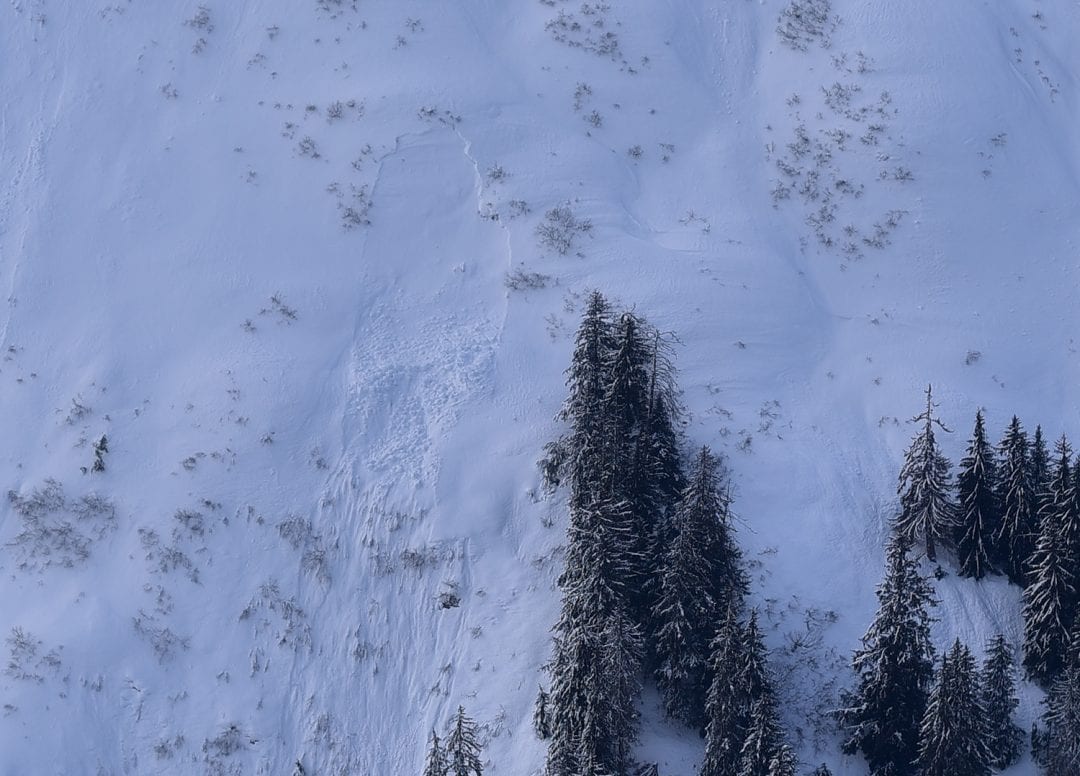
Avalanche Activity
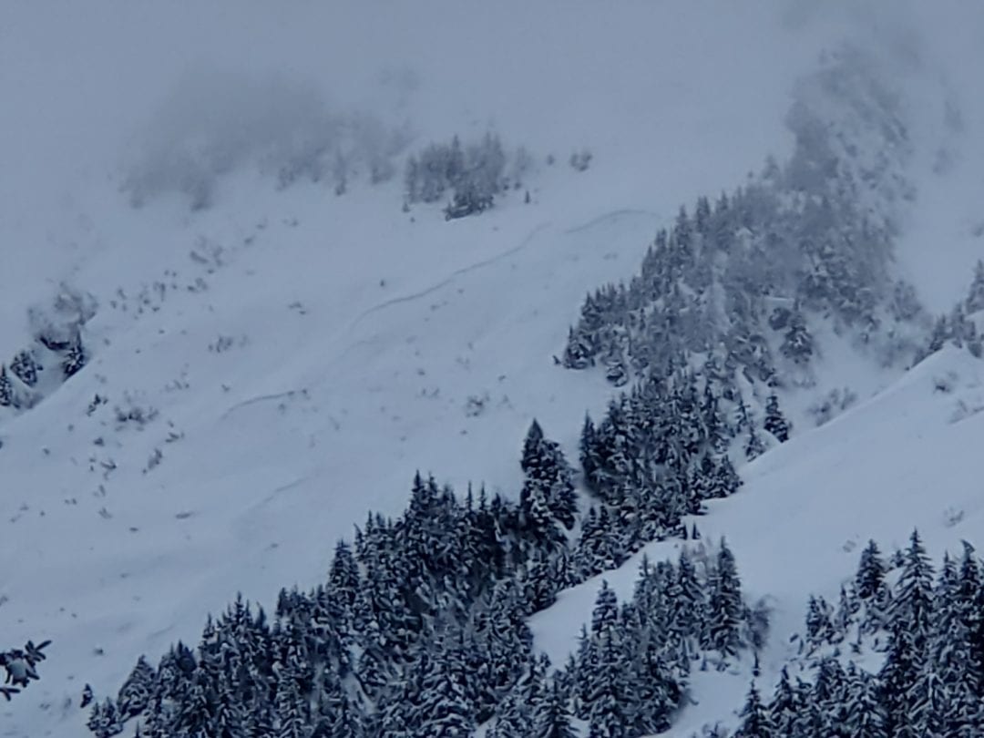
- March 9th – Drainage wide collapse, or whumph, over alders E-Aspect below 1500′. Transitional Zone.
- March 6th – Recent D2 naturals N-Aspect 1500′, E-Aspect 1500′ & NE-Aspect 3200′. Transitional Zone.
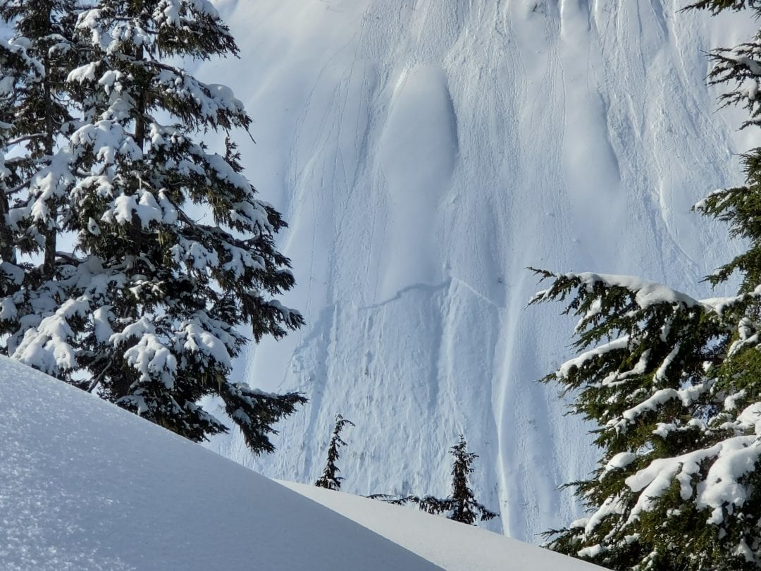
- February 26th – D2 storm slab NE-aspect at 3100′. Lutak Zone.
- February 4th – D2 pocket is a good example of old wind slabs in cross-loaded pocket 1500′.
Weather
Very cold overnight single digit temperatures at elevation. 25-35 mph northwest wind that began Friday will lighten Sunday. Temperatures will remain well below freezing as snow moves into the area on Monday. Temperatures begin to rise above freezing on Tuesday. Last week light north wind, turned to the South on Wednesday and recent storm totals were anywhere between 3″ and 3′.
| Snow Depth [in] | Last 24-hr Snow/SWE [in] | Last 3-days Snow/SWE [in] | Today’s Freezing Level [ft] | Today’s Winds | Next 24-hr Snow/SWE | |
| Mount Ripinsky @ treeline | 140″+* | 0″ / 0.00* | 5″ / 0.40* | 0′ | light, N | 12″ /1.25* |
| Flower Mountain @ treeline | 103″ | 0″ / 0.00 | 2″ / 0.20 | 0′ | light, N | 12″ /1.25* |
| Chilkat Pass @ 3,100ft | 55″ | 0″ / 0.00 | 2″ / 0.10 | 0′ | moderate, N | 10″ /1.00* |
( *star means meteorological estimate )
—The Mt. Ripinsky weather station is completely buried and no longer reporting.—
Additional Information
Practice like you play. Make sure all your rescue gear it is fully functional and your beacon has full batteries. Make sure 1) everyone in the group has a functioning beacon, shovel and probe 2) knows how to use them and 3) has trained in companion rescue in the last year. Keep your skills fresh. If you head into the hills, watch out for red flag avalanche conditions, natural avalanches, whoomphing or collapsing, and shooting cracks.
Education Video Links:
- AIARE
- How to Practice Avalanche Rescue Snowmobile Edition: https://youtu.be/2ML499MMDfM
- AK Sled Shed Motorized Learning:
- Intro: https://youtu.be/aoagKHfGkxs
- Personal Electronics in Avalanche Terrain: https://youtu.be/2Vz9S0OEyFk
- Snowmobile Macgyver Tool Kit: https://youtu.be/4WBNu_t6Bbk
- Head and Face Protection: https://youtu.be/jIzW89wOyZI
- Pre-season prep: https://youtu.be/zJmrb8cZlR4
- My Transceiver: https://youtu.be/yblaDWP7Jf8
- BCA Avalanche Safety for Snowmobilers
- How to Fix Common Snowmobile Problems in the Field: https://youtu.be/g9fiTxEvuFk
- Sleducation: Avalanche Safety for Snowmobilers: https://youtu.be/EWFOd_9DYb8
- Intro to Avalanche Transceivers for Snowmobilers: https://youtu.be/6ZLSBmsceog
- Avalanche Transceiver Trailhead Test for Snowmobilers: https://youtu.be/rWoXbadFBsY
- Avalanche Transceiver Searching Use Snowmobiles: https://youtu.be/w1ucyI6LMXM
- BCA Avalanche Rescue Series
- Beacon Search 101: https://youtu.be/nnHXLVA2FcE
- Avalanche Probing 101: https://youtu.be/-0_yDN5Drzw
- Avalanche Shoveling 101: https://youtu.be/dGQg9o3vAkM
- Organizing a Backcountry Rescue: https://youtu.be/gywtmukgt8s
- Post Avalanche Patient Care: https://youtu.be/9FyIeUy4wpQ
- Backcountry Evacuation: https://youtu.be/WPF-dciefL8
- Complex Multiple Burials Backup Techniques: https://youtu.be/pB6AfY2KyYo
- National Avalanche Center
- Avalanche Problems Explained: https://youtu.be/DkbnT_9-cHU
- Intro to North American Avalanche Danger Scale: https://youtu.be/r_-KpOu7tbA
Alerts
Click the + Full Forecast link below for each zone to read more. BOTTOM LINE THIS WEEKEND: Hazardous conditions exist. We still have a complex snowpack, keep your safety margin wide. Widespread wind loading is adding stress to buried weak layers. Solar radiation weakens snow and can trigger avalanches naturally.