Valdez
Above 3,000ftModerate
1,500 to 3,000ftModerate
Below 1,500ftModerate
Degrees of Avalanche Danger
Avalanche Problems
Problem 1

Likelihood:
- Almost Certain
- Very Likely
- Likely
- Possible
- Unlikely
Size:
- Historic
- Very Large
- Large
- Small
Trend
- Increasing
- Steady
- Decreasing
Problem 2

Likelihood:
- Almost Certain
- Very Likely
- Likely
- Possible
- Unlikely
Size:
- Historic
- Very Large
- Large
- Small
Trend
- Increasing
- Steady
- Decreasing
Problem 3

Likelihood:
- Almost Certain
- Very Likely
- Likely
- Possible
- Unlikely
Size:
- Historic
- Very Large
- Large
- Small
Trend
- Increasing
- Steady
- Decreasing
Avalanche Activity
Sometime around 1/10- There have been several natural windslabs that have released in the Thompson Pass region:
-South slope of catchers mitt, near 27 mile icefall,~3500′, ~300m wide ,~3′ deep, ran 500′ HS-N-R3-D2.5. Photo shows extent of crown, which may have been bigger and is now filled in by wind transported snow.

– Gully Between Little and Big Oddessey, NW, 4000′, ~60 M wide, ~2-4′ crown, ran 1000′
-Averys, ~4000′, SW, ~70 M wide, ran ~1000′
1/11- Two natural wind slab avalanches observed at moonlight basin, 2500′-2800′, S aspect.
The first was on the small last roll before the road and had debris chunks up to 3′ deep “crown filled in by wind”, 200′ wide.
The second was in a cross loaded gully ~ 300′ above the road, with a crown up to ~10′ deep, ~100′ wide. 
1/7- Report of a Glide crack release on snowslide gulch at ~3000′. D2-2.5, crown depth ~ 3 meters. Release did not produce sympathetic avalanches.
Numerous D3 avalanches were observed on the east side of the road, north of Thompson Pass. Between Gully 1 and Cracked Ice, every buttress had significant avalanches originating from ~3000-3500 ‘, NW-NE aspects. Gully 1 and 2 had debris in the drainages, with Gully 2 running a considerable distance into the flats. These avalanches most likely ran between 12/29 and 12/31 during a significant spike in temperatures. There were many other naturals during this period. Many of these have been filled in by new snow and are being blowing in by the current wind event, making them hard to see.
12/31 Numerous small-medium natural avalanches observed below 4000′ on steep rollovers on the north side of the pass.
12/30 Natural avalanche observed on Cracked Ice Butress at 2700′. ~300 meters wide, 1 meter+ deep. Connected through gullies and over ridges.
D3 avalanche on east face of Mt. Tiekel (MP 50). Ran into top 1/3 of apron.
12/28- Several natural avalanches reported in the 54 mile area near brush line. 100′ wide and ran 300′. Depth was not observed.
12/26- Skier triggered avalanche on Cracked Ice Buttress: N aspect, 2500′, 37° slope, 18 inches deep, 100 feet wide, ran 200-300 feet. SS-ASu-D1-R1-I
12/24- Skier triggered avalanche on Python Buttress: NW aspect, 2700′, 35° slope, 60 feet wide, ran 200-300 feet. SS-ASu-D1.5-R1-O
Weather
1/22
The Thompson Pass Mountain Forecast covers the mountains (above
1000 ft) surrounding Keystone Canyon through Thompson Pass to
Worthington Glacier.

This forecast is for use in snow safety activities and emergency
management.

                   Today        Tonight

Temp at 1000`      20 F         10 F

Temp at 3000`      18 F         8 F

Chance of precip   60%          0%

Precip amount
(above 1000 FT)    0.06 in      0.00 in

Snow amount
(above 1000 FT)    0-2 in       0 in

Snow level         sea level    sea level

Wind 3000` ridges  E 1-14 mph   NE 3-30 mph

Remarks...None.
| 24h snowfall (inches) | HN24W (inches)* | Hi Temp (F) | Low Temp (F) | January snowfall | Season Snowfall | Snow height | |
| Valdez | .5 | .03 | 27 | 12 | 20 | 90 | 38 |
| 46 mile | 0 | 0 | 0 | -12 | 6 | 47 | 16 |
|
Thompson Pass “DOT” |
– | – | 22 | 7 | 24 | 319 | 78 |
HN24W= total water received last 24 hours in inches
Additional Information
Our area has received 6-10 inches of snow with the latest storm (1/19-20). This new snow is sitting on a variety of wind affected surfaces, ranging from snow that is stripped down to rain crust, to pencil hard wind slab that ranges from 1-3 feet deep. The new snow will initially have a difficult time bonding to areas that were previously hard wind board. On 1/20, long shooting cracks were observed in the new snow and was releasing from slopes that were previously wind board, and steeper than 30°.
Beneath the wind affected snow we have a variety of faceted snow. This includes near surface facets that are buried by 6-10 inches of new snow. As you move down in the snowpack, below 4000′, we have old rain crusts that have turned to facets and created defined layers within the snowpack. Above 4000′, where those rain crusts don’t exist, the layers are less defined and the snowpack structure is better. However, the recent arctic weather has promoted facet growth in the snowpack at all elevations.
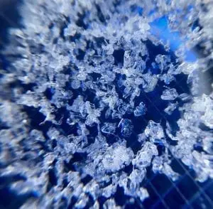
Near surface facets found at 3000′ on Billy Mitchell 1/19. 2 MM grid.
There have been limited observations from interior locations due to low snow at lower elevations. Use caution if you travel in these areas.
If you see something in the mountains that could contribute to this forecast, leave a public observation. The more observations we receive, the better we can tune our forecast.
Forecast Confidence is Moderate.
Announcements
The avalanche hazard is moderate at all elevations. Human triggered avalanches are possible within the new snow up to 1 foot deep, on slopes steeper than 30°. Avalanches within the new snow have the potential to step down into deeper layers of the snowpack. Avoid unsupported terrain, areas that are experiencing active wind loading and terrain traps. Look for the hazard to increase when outflow winds arrive sometime today and create new wind slabs.