Valdez
Above 3,000ftModerate
1,500 to 3,000ftModerate
Below 1,500ftModerate
Degrees of Avalanche Danger
Avalanche Problems
Problem 1
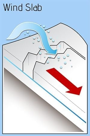
Triggering a wind slab avalanche today will remain possible in specific locations up to 2 feet in depth. Light to moderate winds over the last 2 days have built shallow wind slabs on lee aspects, although deeper slabs (up to 2 feet) exist in isolated locations depending upon terrain influence.
Outflow winds are forecasted to increase in strength today with gust up to 25 mph for Thompson Pass. This slight uptick in wind will build the depth of slabs previously formed in wind channeled terrain. New slabs will likely form in some areas previously unaffected by wind, as increasing wind will likely affect a larger area than the last couple of days.
Areas where new wind slabs are forming will be the most sensitive to human and machine triggers, but are expected to be shallow (less than 1 foot). Wind slabs formed 48 hours ago will be more stubborn to triggers than freshly loaded slopes, but they will be deeper.
Watch for signs of instability such as shooting cracks and slopes being actively loaded by wind.
The hazard will be lower in areas unaffected by wind.
Likelihood:
- Almost Certain
- Very Likely
- Likely
- Possible
- Unlikely
Size:
- Historic
- Very Large
- Large
- Small
Trend
- Increasing
- Steady
- Decreasing
Problem 2
Faceted snow in the bottom portion of our snowpack continues to exist in all three climate zones. Human triggered or natural avalanches have not been reported or observed at this layer since 12/16. At this point, it is unlikely for a person to trigger an avalanche at this layer . Although, trigger points may still exist in isolated locations like thin rocky areas where the overlying slab is thinner and a person or machine could affect weak facets near the ground.
In most locations above brush line very hard wind damaged snow is overlying persistent weak layers. This has effectively created a bridging affect and is one reason why affecting these layers, is not currently likely. Remember that unlikely does not mean impossible. Realize that this flaw in our snowpack exists and keep that information in mind while making terrain decisions in the future.
The most likely areas to trigger a persistent slab avalanche will be in the Continental zone where a more faceted snowpack is in place and previous wind events were less severe. Below brush line is also a concern as alders provided shelter from winds allowing persistent grains to survive near the surface as well as colder temps that would promote facets during inversions.
Likelihood:
- Almost Certain
- Very Likely
- Likely
- Possible
- Unlikely
Size:
- Historic
- Very Large
- Large
- Small
Trend
- Increasing
- Steady
- Decreasing
Avalanche Activity
Below is a summary of observed Avalanche activity from the last 7 days. Avalanches that were noted earlier in the season can be viewed by clicking the link below.
If you trigger or observe a natural avalanche consider leaving a public observation.
Very little natural avalanche activity was reported or observed above freezing line for the New Years storm. A crown on the north face of Tones Temple and SW face of Acapulco were noted. These occurred mid storm within the new snow and were mostly filled in. Wet loose activity occurred below 2000′ south of Thompson Pass with one large wet loose observed in Keystone Canyon.
Weather
Check out our updated weather tab! A collection of local weather stations are available for viewing with graphs and tabular data included.
NWS Watches and warnings
NONE
NWS Point forecast for Thompson Pass
Date                           Saturday 01/07/23       Sunday 01/08/23
Time (LT)          18    00    06    12    18    00    06    12    18
Cloud Cover        CL    FW    BK    OV    OV    OV    OV    OV    OV
Cloud Cover (%)     5    10    65    85    90   100   100   100    80
Temperature        11     7     8    12    13     9    15    21    24
Min/Max Temp                    7          16           9          24
Wind Dir            E     E    NE    NE    NE    NE    NE     E     E
Wind (mph)          5     4    13    20    18    13    16    10    10
Wind Gust (mph)    18    19    29    36    34    32    34    28
Precip Prob (%)     5     5     0     5    60    70    80    90    40
Precip Type                                 S     S     S     S     S
12 Hour QPF                  0.00        0.02        0.20        0.24
12 Hour Snow                  0.0         0.0         3.6         3.7
Snow Level (kft)  0.0   0.0   0.0   0.0   0.0   0.1   0.2   0.2   0.5
Click on link below for Thompson Pass weather history graph:

| Date:
01/07 |
24 hr snow | HN24W* | High temp | Low temp | 72 hour SWE* | January snowfall | Seasonal snowfall | Snowpack Depth |
| Valdez | 0 | 0 | 25 | 23 | .36 | 5 | 102 | 37 |
| Thompson pass | 0 | 0 | 11 | -3 | .55 | 33 | 227 | 45 |
| 46 mile | 0 | 0 | -1 | -18 | N/O | 20 | ~56** | 42 |
*HN24W- 24 hour Snow water equivalent in inches
*SWE– Snow water equivalent
**46 mile seasonal snowfall total begins December 1st.
Additional Information
Click on the link below for a running summary of the seasons weather history.
Announcements
The avalanche hazard is moderate at all elevations. Human triggered wind slab avalanches will be possible 1-2 feet deep in specific locations. These include lee slopes and cross loaded terrain.
Posted by Gareth Brown 01/07 6:30 am.
For a description of current avalanche problems, weather information, season history and more click the (+ full forecast) button. Avalanche forecasts will be issued Wednesday-Sunday.

