Valdez
Above 4,000ftModerate
2,000 to 4,000ftModerate
Below 2,000ftModerate
Degrees of Avalanche Danger
Avalanche Problems
Problem 1
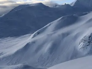
Our forecast area received 4-10 inches of low density snow on 1/11. On 1/13 stable conditions were observed in areas where the surface remains unaffected by wind. Areas that have recently seen wind redistribution, are expected to have sensitive wind slabs on lee aspects. Widespread surface hoar was observed on 1/13 on all aspects and elevations. This will be a problem layer in the future if it is buried intact.
There is currently a lot of low density snow available for transport. Winds are forecasted to gust up to 40 mph through wind channeled terrain, which will be forming sensitive wind slabs in specific areas 1-2 feet in depth. Areas further away from passes and gaps are expected to be calm today, in these areas the hazard will be lower.
Today it will be important to pay attention to what wind has done to snow at the surface. Use test slopes to determine how well new snow has bonded and watch for signs of recent wind loading (hard snow over soft). Signs of instability such as shooting cracks and recent avalanche activity will indicate that slopes steeper than 32° will have the potential to produce avalanches.

Likelihood:
- Almost Certain
- Very Likely
- Likely
- Possible
- Unlikely
Size:
- Historic
- Very Large
- Large
- Small
Trend
- Increasing
- Steady
- Decreasing
Problem 2
For the first time since 12-16 a natural avalanche was reported that failed at faceted snow near the base of our snowpack. This occurred 1/6 on a SW aspect ~3500′ between Catchers Mitt and Loveland Basin, crown 1-6 feet in depth. This is a repeat offender slope when loaded by wind, although is noteworthy due to its depth.
This avalanche has thus far been an outlier, however indicates that the strong wind affected snow that has capped the early season facets may be losing strength (faceting) making weak snow more easily affected by a person or Snowmachine at the surface in certain areas.
Recently our snowpack has been slowly building with light snowfall and calm to moderate winds. This weather will help our snowpack to heal in the longterm but in the short term will be putting incremental stress on weak layers at the base of our snowpack. This is a fine balance and is very difficult to assess as spatial (place to place) variability is currently significant. This recent avalanche is a perfect example that persistent weak layers are difficult to predict/assess and conditions may be different depending upon the area you choose to travel.
In most places at this point, triggering a deep hard slab avalanche is very unlikely, but the consequences would be significant. Keep this in mind when choosing terrain and strive to practice safe protocols. These include: good communication, skiing one at a time and avoiding terrain traps.


Likelihood:
- Almost Certain
- Very Likely
- Likely
- Possible
- Unlikely
Size:
- Historic
- Very Large
- Large
- Small
Trend
- Increasing
- Steady
- Decreasing
Avalanche Activity
Below is a summary of observed Avalanche activity from the last 7 days. Avalanches that were noted earlier in the season can be viewed by clicking the link below.
If you trigger or observe a natural avalanche consider leaving a public observation.
1/13- Numerous natural shallow (D1) soft slab avalanches were observed on all aspects and elevations. These were about 4 inches deep and look to have occurred during peak intensity of the 1/11 snowfall event.
Weather
Check out our updated weather tab! A collection of local weather stations are available for viewing with graphs and tabular data included.
NWS Watches and warnings
NONE
NWS Point forecast for Thompson Pass
Date               Thursday 01/12/23       Friday 01/13/23
Time (LT)          06    12    18    00    06    12    18    00    06
Cloud Cover        OV    OV    SC    OV    OV    OV    OV    OV    OV
Cloud Cover (%)    70    70    35    75    85    90    85    95    90
Temperature        19    22    19    13    16    20    19    15    17
Max/Min Temp                   23          13          22          14
Wind Dir            E     E    NE    NE    NE     E    NE    NE    NE
Wind (mph)          5     5     8     6     6     4     4     4     4
Wind Gust (mph)
Precip Prob (%)    30    30     5     0     5    10    10    30    30
Precip Type         S     S                                   S     S
12 Hour QPF                  0.04        0.00        0.00        0.02
12 Hour Snow                  0.0         0.0         0.0         0.0
Snow Level (kft)  0.7   0.7   0.5   0.3   0.3   0.3   0.3   0.1   0.2
Click on link below for Thompson Pass weather history graph:

| Date:
01/14 |
24 hr snow | HN24W* | High temp | Low temp | 72 hour SWE* | January snowfall | Seasonal snowfall | Snowpack Depth |
| Valdez | 0 | 0 | 27 | 20 | .15 | 16 | 113 | 43 |
| Thompson pass | 0 | 0 | 7 | -1 | N/O | 46 | 240 | 35 |
| 46 mile | 0 | 0 | 2 | -10 | 0 | 24 | ~60** | 38 |
*HN24W- 24 hour Snow water equivalent in inches
*SWE– Snow water equivalent
**46 mile seasonal snowfall total begins December 1st.
Additional Information
Click on the link below for a running summary of the seasons weather history.
Announcements
The avalanche hazard is moderate at all elevations. North wind with gusts to 40 mph are forecasted for Thompson Pass. Fresh wind slabs will be forming in wind channeled terrain that will be initially sensitive to human triggers 1-2 feet in depth. Pay attention to wind affect at the surface and watch for signs of instability such as shooting cracks, recent avalanche activity and collapsing.
Posted by Gareth Brown 01/14 8:00 am.
For a description of current avalanche problems, weather information, season history and more click the (+ full forecast) button. Avalanche forecasts will be issued Wednesday-Sunday.