Valdez
Above 4,000ftConsiderable
2,000 to 4,000ftConsiderable
Below 2,000ftConsiderable
The Avy Rose shows the forecasted danger by elevation and aspect. It adds more detail about where you are likely to find the dangers mentioned in the forecast. The inner circle shows upper elevations (mountain top), the second circle is middle elevations, and the outer circle represents lower elevations. Think of the Rose as a birds-eye view of a mountain, looking down from above. The rose allows our forecasters to visually show you which parts of the mountain they are most concerned about.
Degrees of Avalanche Danger
Avalanche Problems
Problem 1
The weather forecast is calling for snowfall rates to slowly increase through the day and become heavy by this evening. Once our area receives more than 10 inches of snow or snowfall rates exceed 1 inch per hour human triggered avalanches will become likely and natural avalanches will be possible. We currently have a bed surface, a slab will be building through the day, and a weak layer will initially exist at the new snow/old snow interface. These are the three ingredients necessary for avalanches to occur.
The depth of avalanches a person could trigger will initially be limited to the new snow. If we receive more than 2 feet of snow, persistent weak layers may reactivate and the avalanche danger would move to HIGH.
Pay attention to signs of instability like shooting cracks collapsing or recent natural avalanche activity. These would all be bullseye indicators that our thin early season snowpack is being overwhelmed.

Likelihood:
- Almost Certain
- Very Likely
- Likely
- Possible
- Unlikely
Size:
- Historic
- Very Large
- Large
- Small
Trend
- Increasing
- Steady
- Decreasing
Problem 2
We currently have a thin (weak) snowpack in place. The pack is comprised of thick windslabs on lee aspects that overly various old rain crusts. Windward aspects are scoured to old rain crusts, ground and old wind affected snow at upper elevations. Old rain crusts have promoted faceting above and below them creating significant faceting in the mid and lower snowpack.
These weak layers will be tested over the next 48 hours as a significant snow storm is forecasted for all three of our snow climate zones. Depending on the amount of snow we receive, wind strength and how high the freezing line goes, it is possible that these layers could go past the tipping point and produce a natural avalanche cycle and HIGH avalanche hazard by late Sunday night/ Monday morning.
It is recommended that if we choose to travel in the mountains late today through Monday, that we make conservative terrain choices, watch for signs of instability and avoid runouts of large avalanche paths.

Likelihood:
- Almost Certain
- Very Likely
- Likely
- Possible
- Unlikely
Size:
- Historic
- Very Large
- Large
- Small
Trend
- Increasing
- Steady
- Decreasing
Avalanche Activity
11/14- Debris from a D3 natural avalanche at snow slide gulch ended 100 vertical feet above the Lowe river.
Large avalanches (D2-2.5)also occurred in multiple other locations including Berlin Wall, Catchers Mitt, South Three Pigs and Billy Mitchell. The activity extends beyond this list, and mostly occurred during the peak of warming and precipitation on 11/13.
Multiple natural D1-1.5 avalanches were observed on multiple aspects at low elevation. No step downs noted.
12/1- 2 D2.5 natural avalanches were noted on Three Pigs (Beaver slide, Pig Leg). Pig leg ran into the top 1/3 of the fan and Beaver Slide stopped near the end of its track. These both likely occurred during the outflow wind event 11/26-11/29.

D2 natural wind slab was observed on 40.5 mile peak on a west aspect ~3000′. Crown depth range estimated 1-2 feet and 200′ long

12/9- Several D2 natural wind slab avalanches were observed on S-W aspects at mid elevation in the intermountain region. Crowns appeared to be 1-3 feet deep. Catchers Mitt and Gully 1 were among the spots affected.
Weather
Check out our updated weather tab! A collection of local weather stations are available for viewing with graphs and tabular data included.
NWS Watches and warnings
A winter storm warning will be in effect beginning at 3pm for
the Copper River Basin.  There is currently no warning for the
Thompson Pass/ Valdez area although high snowfall amounts are
expected.
NWS Point forecast for Thompson Pass
Date               Sunday 12/11/22         Monday 12/12/22
Time (LT)          06    12    18    00    06    12    18    00    06
Cloud Cover        OV    OV    OV    OV    OV    OV    OV    OV    OV
Cloud Cover (%)    95   100   100   100   100   100    90    70    80
Temperature        10    15    18    21    24    24    22    17    16
Max/Min Temp                   19          16          25          14
Wind Dir           SE    SE    SE     E    SE     E     N    NE    SE
Wind (mph)          6    12    14    28    23    14    20     9     6
Wind Gust (mph)          24    34    48    44    33    43    32    25
Precip Prob (%)    70   100   100   100   100    80    40    30    50
Precip Type         S     S     S     S     S     S     S     S     S
12 Hour QPF                  0.27        0.82        0.33        0.05
12 Hour Snow                  4.7        11.9         4.4         0.0
Snow Level (kft)  0.0   0.0   0.0   0.7   1.2   0.6   0.0   0.0   0.0
Click on link below for Thompson Pass weather history graph:

| Date:
12/11 |
24 hr snow | HN24W* | High temp | Low temp | 72 hour SWE* | December snowfall | Seasonal snowfall | Snowpack Depth |
| Valdez | 0 | 0 | 25 | 17 | 0 | 10 | 34 | 19 |
| Thompson pass | 0 | 0 | 13 | -4 | 0 | 8 | 109 | 26 |
| 46 mile | 0 | 0 | 1 | -6 | 0 | 2 | 2** | 16 |
*HN24W- 24 hour Snow water equivalent in inches
*SWE– Snow water equivalent
**46 mile seasonal snowfall total begins December 1st.
Additional Information
Our snow season began with above average precipitation and temperatures. Beginning in September, snow lines generally hung around 4500′ until 10/12. At that point our area received the first snow down to sea level with 12-16 inches on the north side of Thompson Pass.
On 10/15 wet conditions continued with the freezing line rising to 5000′ or higher. As skies finally cleared on 10/22 we were left with a thin rain saturated snowpack capped by a stout rain crust up to 4500′. Above 4500′ much deeper snowpacks existed due to significant early season snowfall at upper elevations.
Dry and cold conditions along with moderate outflow winds finished out the month of October.
On 11/1 precipitation returned with 18 inches of snow and ~1″ of SWE on Thompson Pass. This new snow was initially reactive with several natural D2 avalanches reported on Thompson Pass. These slides were running on a firm bed surface consisting of old rain crusts and old wind slabs from October.
On 11/4 a strong north wind event kicked up with 65 mph+ winds on Thompson Pass. Our snowpack received significant damage as already thin snow below 4500′ was stripped down to old wind slabs, rain crusts and the ground.
Precipitation returned on 11/8 and became heavy on 11/11. Storm totals of around 50 inches were recorded at Thompson Pass DOT between 11/8-11/13. Snow lines rose to ~3000′ near the tail end of the storm with heavy rain occurring in low lying areas.
Skies cleared on 11/14 through 11/18 with a strong temperature inversion setting up. Valley temperatures north of Thompson Pass fell to 0° F with above freezing temperatures existing above 4000 feet. Valdez temps remained mild. This weather allowed for widespread surface hoar up to 1 cm to develop in low lying areas.
Precipitation returned on 11/19, with incremental snowfall on Thompson Pass and areas north. The Valdez area received rain during this period. 12 inches have been recorded at TP DOT between 11/9-11/23.
11/26-11/29- Strong outflow (N) wind event. Many areas below 3000′ were stripped to the 11/13 rain crust, destroying the 11/19 BSH layer. Widespread very hard snow surfaces were the result.
Precipitation returned to our area on 12/5, with higher accumulation amounts near the coast. As storms cleared out on 12/7, they were directly followed by another round of strong north winds.
Announcements
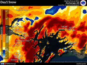
The avalanche hazard will begin as Moderate and move to Considerable at all elevations during the day as heavy snowfall sets in. 20-24 inches of new snow is forecasted at upper elevations in the next 24 hours. Human triggered avalanches will become likely within the new snow as snowfall rates increase. Watch for signs of instability such as shooting cracks, collapsing and natural avalanche activity that would indicate new snow is beginning to overwhelm the snowpack.
Posted by Gareth Brown 12/11 8:00am.
For a description of current avalanche problems, weather information, season history and more click the (+ full forecast) button. Avalanche forecasts will be issued Wednesday-Sunday.