Valdez
Above 4,000ftConsiderable
2,000 to 4,000ftConsiderable
Below 2,000ftConsiderable
Degrees of Avalanche Danger
Avalanche Problems
Problem 1
Our snowpack is currently undergoing a big change from a winter snowpack to a spring one. During this change stress is applied to the surface as well as deeper layers in the snowpack during the heat of the day. During this transition human triggered and natural avalanches become increasingly likely during specific times of the day.
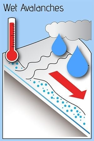
The most likely avalanche problem to be encountered today will be wet loose avalanches. These will be likely on east and west aspects up to 4000′ and on south aspects at all elevations. Northerly aspects are unlikely to have wet loose activity, although sensitivity of wind/persistent slabs will increase during the heat of the day (see problem 2+3).
Avoiding traveling on or being exposed to steep solar aspects should be a major consideration today. Natural wet loose activity has the potential to step down to deeper layers producing destructive slab avalanches. Timing is key with avoidance of this problem. Strong melt/freeze crusts will be in place today on solar aspects, as these break down and become moist-wet the hazard will increase. The first aspect to heat up will be East, followed by South and then finally West and Northwest.
Likelihood:
- Almost Certain
- Very Likely
- Likely
- Possible
- Unlikely
Size:
- Historic
- Very Large
- Large
- Small
Trend
- Increasing
- Steady
- Decreasing
Problem 2
Incremental snowfall that we have received over the last 10 days rests on a variety of snow surfaces that will affect the likelihood of human triggered avalanches that may occur 1-2 feet in depth. Bed surfaces range from hard wind board, melt freeze crusts and near surface facets. The later interface is currently a layer of concern. New snow depths since the 10th vary significantly across our forecast zone with some areas only having a few inches and others having as much as 2 feet. In areas with deeper storm totals that overlie near surface facets, human triggered avalanches are possible. The sensitivity of these slabs will increase during the heat of the day.
Deeper in the snowpack faceted snow exists in most location at and below the 3/17 interface. A very large natural avalanche occurred on Meteorite on 4/15 that likely was initiated at this interface and then stepped down to the ground (see problem 4). This is a clear sign that the changing of seasons to warmer temps has the potential to affect deeper layers in our snowpack.

Likelihood:
- Almost Certain
- Very Likely
- Likely
- Possible
- Unlikely
Size:
- Historic
- Very Large
- Large
- Small
Trend
- Increasing
- Steady
- Decreasing
Problem 3
Wind slabs up to one foot in depth exist in specific locations. Changing wind directions over the last few days has left wind slabs on a variety of aspects on the lee of high elevation ridge lines, cross loaded terrain and catchment features of steep terrain. Human triggered wind slab avalanches are possible up to one foot in depth in steep terrain.
The depth, distribution and sensitivity of this avalanche problem is expected to increase over the next 24 hours as north winds are expected to become moderate to strong overnight on the 16th.

Likelihood:
- Almost Certain
- Very Likely
- Likely
- Possible
- Unlikely
Size:
- Historic
- Very Large
- Large
- Small
Trend
- Increasing
- Steady
- Decreasing
Problem 4
Weak snow exists at the base of our snowpack. On 4/15 our area saw the first deep slab activity occur since late February. This occurred on Meteorite (see avalanche activity section) and was a persistent slab that stepped down to the ground. This is a clear indication that depth hoar could produce more activity later in the season while our snowpack is undergoing a transition from a winter snowpack to a spring one.
This problem is very difficult to assess due its depth and the fact that signs of instability will likely not be present. You can stack the odds in your favor by avoiding steep terrain that is undergoing rapid changes such as rapid warming and avoiding exposure to large triggers such as cornices.

Likelihood:
- Almost Certain
- Very Likely
- Likely
- Possible
- Unlikely
Size:
- Historic
- Very Large
- Large
- Small
Trend
- Increasing
- Steady
- Decreasing
Avalanche Activity
Below is a summary of observed Avalanche activity from the last 7 days. Avalanches that were noted earlier in the season can be viewed by clicking the link below.
If you trigger or observe an avalanche consider leaving a public observation.
4/15- Very large natural avalanche on Meteorite. This intiatied as a persistent slab around 6200′ NE and stepped down to the ground at 5600′ NE.
SS/HS-N-D3-O/G 6200′ NE, step down to ground ~5600′ NE
4/9- Skier triggered D2 avalanche reported on a wind loaded NW aspect of Berlin Wall ~5400′. Skier was caught and carried, but not buried/ no injuries.
Small wind loaded pockets D1-1.5 were observed to be sensitive to human triggers in cross loaded terrain on Billy Mitchell.
4/7- Numerous D1-1.5 natural dry loose avalanches observed that occurred mid storm 4/5-6. No step downs observed.
Several small (D1) human triggered avalanches were observed along the road corridor where the new snow had been wind affected.
4/6- Skier triggered D1 reported in Gully 1 on a wind loaded convexity.
Weather
Check out our updated weather tab! A collection of local weather stations are available for viewing with graphs and tabular data included.
NWS Watches, warnings and advisories
NONE
NWS Point forecast for Thompson Pass
Date                     Sunday 04/16/23         Monday 04/17/23
Time (LT)          04    10    16    22    04    10    16    22    04
Cloud Cover        OV    OV    OV    OV    BK    BK    SC    SC    OV
Cloud Cover (%)    85    85    90    75    65    70    45    40    70
Temperature        24    28    34    27    22    26    32    23    20
Max/Min Temp                   35          21          32          19
Wind Dir            E     W     N    NE    NE    NE    NE     N     N
Wind (mph)          6     1     4    18    20    16    16    25    29
Wind Gust (mph)
Precip Prob (%)    20    20    30     5     5    20     5     5     0
Precip Type         S     S     S                 S
12 Hour QPF                  0.04        0.02        0.01        0.00
12 Hour Snow                  0.0         0.0         0.0         0.0
Snow Level (kft)  0.5   0.5   1.0   0.5   0.1   0.0   0.4   0.1   0.0
Click on link below for Thompson Pass weather history graph:

| Date:
04/16 |
24 hr snow | HN24W* | High temp | Low temp | 72 hour SWE* | April snowfall | Seasonal snowfall | Snowpack Depth |
| Valdez | 0 | 0 | 48 | 30 | .35 | 11 | 248 | 48 |
| Thompson Pass | 0 | 0 | N/O | N/O | N/O | 12 | 438 | N/O |
| 46 mile | 0 | 0 | 44 | 20 | N/O | ~5 | ~116** | N/O |
*HN24W- 24 hour Snow water equivalent in inches
*SWE– Snow water equivalent
**46 mile seasonal snowfall total begins December 1st.
Additional Information
Click on the link below for a running summary of the seasons weather history.
Announcements
The avalanche hazard is Considerable at all elevations. Human triggered avalanches 1-2 feet deep are likely in steep areas where the surface snow is becoming wet, steep wind loaded terrain and in areas where storm snow from the 9-14th overlies weak snow and is being affected by the sun. Natural avalanches are possible especially at low-mid elevation. Avoid steep terrain where the surface snow is wet due to solar and watch for red flags such as collapsing , shooting cracks and collapsing. Careful snowpack assessment and cautious route finding will be necessary for safe travel in avalanche terrain today.
Posted by Gareth Brown 04/16 8:00 am.
For a description of current avalanche problems, weather information, season history and more click the (+ full forecast) button. Avalanche forecasts will be issued Wednesday-Sunday through April 30th.
If you have pictures of recent natural or human triggered avalanches or notice signs of instability such as shooting cracks or collapsing, leave an observation to help improve forecast accuracy.