Valdez
Above 3,000ftNone
1,500 to 3,000ftNone
Below 1,500ftNone
Degrees of Avalanche Danger
Avalanche Activity
11/15: Natural avalanche observed in Loveland Basin on a South aspect, down the ridge from Tones Temple. This slide was triggered by recent NE wind loading and failed at the ground. SS-N-R1-D2-G
11/16: Natural avalanche observed on Billy Mitchell “Cry babys shoulder”. Released from~3500′ with a crown length of ~200 meters, North aspect. This slide was triggered by recent NE wind cross loading the slope. SS-N-R2-D2-U
Weather
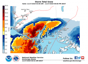
11/27- A train of low pressure systems is forecasted to deliver wind and snow to the Valdez/Thompson Pass region through mid week. Over 8″ of SWE is forecasted for the next week, this translates to significant snow accumulation if this scenario plays out as forecasted…

The Thompson Pass Mountain Forecast covers the mountains (above
1000 ft) surrounding Keystone Canyon through Thompson Pass to
Worthington Glacier.

This forecast is for use in snow safety activities and emergency
management.

                   Today        Tonight

Temp at 1000`      31 F         28 F

Temp at 3000`      27 F         25 F

Chance of precip   60%          80%

Precip amount
(above 1000 FT)    0.15 in      0.20 in

Snow amount
(above 1000 FT)    1-2 in       1-3 in

Snow level         600 ft       sea level

Wind 3000` ridges  E 10-20 mph  NE 10-20 mph

Remarks...None.
Thompson Pass weather history 20/21. Click on links below the images to see full size view

Announcements
Early Season conditions exist on Thompson Pass. A thin snowpack has yet to cover up many hazards such as rocks, rivers and crevasses. The current snowpack depth is 13” at the Thompson Pass DOT, and 33” at Nicks 4500’. Our area received a storm 11/8-9 with Thompson Pass reporting 16” of new snow, after a brief break we’ve received additional accumulations 11/11-12.
As our snowpack grows, it’s important to keep in mind that a thin/weak snowpack can’t adjust as quickly, or as well to dramatic weather changes like a late winter/spring snowpack can. These changes include: More than 6” of new snow within 24 hours, wind that transports snow, rapid warming and rain on snow.
Use caution if traveling in or below avalanche terrain. Seeing natural avalanches, shooting cracks in the snow, or collapsing in the snowpack are all sure signs of instability.
Snow and weather updates will be posted as conditions change. Regular avalanche forecasts will begin for the 20/21 season soon. In the meantime check our observations page.
Your observations are valuable! If you have been out recreating in the mountains leave an observation.