Valdez
Above 3,000ftLow
1,500 to 3,000ftLow
Below 1,500ftLow
Degrees of Avalanche Danger
Avalanche Activity
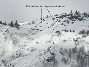
3/26: Small natural wet slab avalanche that originated from a point release was observed at MP 40 on a south aspect. 100′ wide, originating from ~2000′, ran to ground.
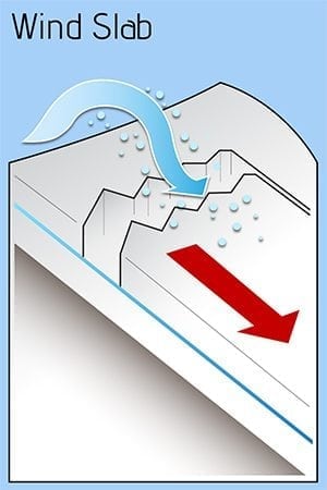
3/22: Small snowboard triggered wind slab avalanche reported in skate park. ~3000′, southeast aspect, 1 foot deep, ~40′ wide. SS-ARu-R1-D1.5-I. Other small natural releases were reported in the area as well.
3/14: Numerous D1 wet loose avalanches observed 3/14 on south aspects in steep terrain.
- Glide crack release on the north side of slater creek “east peak zone”, south aspect ~3500′.
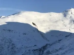
3/11: 2 Human triggered avalanches observed on the Thompson Pass corridor.
- Snowmachine triggered avalanche directly above the Thompson Pass airstrip. Released from a thin section of windslab which then stepped down and released the entire snowpack on an unsupported slope. Crown was about 10 feet deep. HS-AMu-D2-G

Skier triggered avalanche in Nicks Happy Valley. Skier was traversing the wind loaded northwest aspect of the gully and released a slab ~1 foot deep and 100′ wide, ran ~150 vertical feet to the bottom of the gully. SS-ASu-D1.5-I.
3/5: -Natural D 2.5 occurred on the NW aspect shoulder of the Python Buttress “Ptarmigan Drop” milepost 31. Avalanche crown was reported to be 10-15 feet deep by DOT and ran to the ground. Crown was quickly filled back in by intense snow transport.
- Natural D3 occurred directly across from the Tsaina lodge on a south aspect of Hippie Ridge. Originated at 4000′, ~1500′ wide, stepped down twice and ran to the ground .

- Natural D2 on south aspect of Hippie Ridge 1 mile north of previously mentioned avalanche. 4500′ created 2 sympathetic avalanches on either side at 4000′

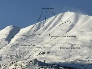
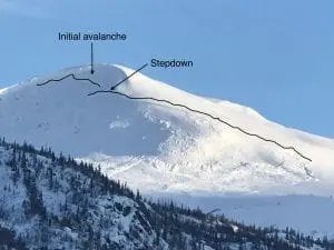
- Natural D3 on the south face of South Tiekel. Originated from 3 smaller slides at ~5700′ and stepped down multiple times and eventually ran to the ground. Initial step-down propagated an avalanche 2-3000′ wide. Ran full path. There were reports that sympathetic avalanches were associated with this avalanche over a mile away. Photo from over 2 miles away.
3/4: A natural D3 avalanche ran above the 37 mile tsaina bridge. South aspect ~5500′, stepped down multiple times, ran to the ground in places. The main debris fell short of the highway, mature uprooted trees 6-12 inches in diameter were thrown onto the road by powder blast.

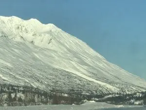
-The gully downstream of Bridal Veil Falls produced a large avalanche, D2.5, that buried the river with over 10′ of debris, the powder blast pushed sticks into the parking lot on the other side of the road.
3/3: DOT mitigation work produced another large avalanche that affected the Richardson Highway at ~ mile 39. Initial reports stated that the avalanche buried the highway under 15 feet of debris for ~500 feet.
2/28: Natural wind slab avalanche 4000′. N-HS-R2-D2, West aspect slope that descends from Crudbuster basin into IguanaBacks. Stepped down immediately below initial crown, to the ground in places.

2/26: Large natural observed at 48 mile off Point 5064 (Stuart). N-HS-R3-D3, N-W aspects. Observed from the highway. Looked fresh, probably within the last 24 hours. Appears to have released from a N aspect bowl ~40-45° at~4500′, then stepped down and wrapped around the corner onto NW-W aspects. Crown on step down is estimated to be over 3 meters deep in places. Couldn’t see extent of track length. Crown was over 1/2 mile wide. 3 small, sympathetic pockets were observed over 1/2 mile away in moderate terrain with crowns ~1-2 meters. Picture taken from over 3 miles away.
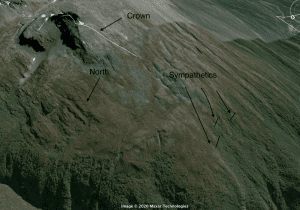
2/24: Natural avalanche observed on the north face of Goodwills’ ~5500′, D-2.5, 200-300′ wide. Ran to the bottom of the slope ~600′, crown ~5′ deep.

2/23: – Natural avalanches D2-2.5 on the east face of Mt. Tiekel were observed.
- At the headwaters of Quartz Creek, MP 54, a large group of snowmachiners potentially remotely triggered a D2 avalanche. See observations page.
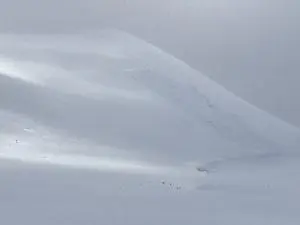
2/21: Multiple natural and human triggered avalanches were observed 2/21.
- A natural avalanche hit the road near 39 mile. This natural originated from mid-slope elevations and put a small amount of debris onto the road. DOT mitigation efforts produced a D 3.5 avalanche that originated from the upper mountain ~6000′ and stepped down multiple times. Crown depths were reported as significant. Debris 6-15 feet deep buried 1000′ of the Richardson Highway.

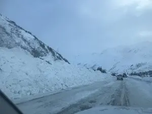
Debris along the highway after DOT cleanup work.
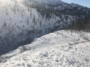
Debris that over ran the highway and was deposited into the Tsaina Gorge.
- A natural released at the toe of Worthington Glacier on a slope just south of the toe on a north east aspect. Crown was over 400′ wide and crown depth averaged 3-5 feet and stepped down to over 10′ deep at one point. There was a small sympathetic associated as well.
- A small deep pocket (50′ across ~4′ deep) was observed on the east side of the highway below Gully 1 that was remotely triggered by snowmachines high marking above.
- Two small avalanches released off a south slope above the airstrip with unknown trigger. Many snowmachine tracks were present in the area around the slides.

Natural near the toe of the Worthington Glacier.
2/20: Two side by side avalanches were observed on the NW shoulder of the Python buttress ~3500′. Crown 2-300′ across and ~3’+ deep. These slides ran into the flat ~800 vertical feet. Slides were triggered by DOT mitigation work 2/19.
2/20: 2 paths on Three Pigs at MP 42 slid naturally to the middle to lower portion of their aprons, D2.5. Low clouds prevented ability to see what elevation they originated from.
2/20: A natural avalanche was reported on the north shoulder of Mt Tiekel at ~4500′. Details were limited but the entire slope avalanched and crown was reported to be 2 meters deep. R5-D2.5~.
2/19: A natural avalanche at 32 mile buried the Richardson Highway under 10 feet of snow for ~100′. This caused the highway to close for the majority of the day. This slide released from the lower bench of RFS on a north aspect.
2/14: Dry loose D1-2 natural avalanches were observed running over the Wowie Zowie ice climb in Mineral Creek.
2/13: Natural and human triggered D1 avalanches were observed in Keystone Canyon.
2/12: A D3 avalanche at MP 38 hit the Richardson Highway and closed the road. Released on a south aspect in the upper elevation start zones, ~5500′, and stepped down around 4-4500′. Further DOT mitigation efforts on Three Pigs and 40.5 Mile produced no results.
Weather
3/29: Clear and cold with strong to very strong northeast winds are forecasted through Thompson Pass with highs in the lowers 20’s. There is a high wind warning in effect from 9 am 3/29 through 4 pm 3/30, with gusts up to 75 mph expected on Thompson Pass.
The Thompson Pass Mountain Forecast covers the mountains (above
1000 ft) surrounding Keystone Canyon through Thompson Pass to
Worthington Glacier.

This forecast is for use in snow safety activities and emergency
management.

                   Today        Tonight

Temp at 1000`      21 F         7 F

Temp at 3000`      -8- 3 F      -5- 6 F

Chance of precip   0%           0%

Precip amount
(above 1000 FT)    0.00 in      0.00 in

Snow amount
(above 1000 FT)    0 in         0 in

Snow level         sea level    sea level

Wind 3000` ridges  N 21-48 mph  N 17-48 mph

Remarks...Gusts to 75 mph through Monday afternoon.
| 24h snowfall (inches) | HN24W (inches)* | Hi Temp (F) | Low Temp (F) | March snowfall | Season Snowfall | Snow height | |
| Valdez | 0 | 0 | 29 | 14 | 34 | 195 | 84 |
| 46 mile | 0 | 0 | 25 | 8 | 4 | 99 | 29 |
|
Thompson Pass “DOT” |
0 | 0 | 11 | 2 | 35 | 506 | 84 |
HN24W= total water received last 24 hours in inches
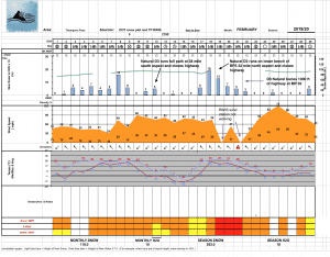
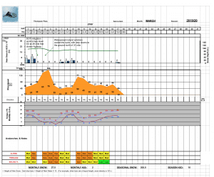
Thompson Pass weather history 19/20 season beginning 12/21. Click on links below to see full size image.


Additional Information
March began with the last significant snowfall of a cycle of snow storms beginning late January. Directly following this storm our area received the strongest wind event of the season, with wind speeds reaching 106 mph on Thompson Pass. This outflow wind event caused a natural avalanche cycle north of Milepost 31, with several very large avalanches originating in upper elevations and stepping down to the ground around 4000′. The majority of this activity occurred on south aspects.
Deep slab avalanches have not been observed since this event.
The rest of March has been mostly dry, with a couple of small storms followed by strong northeast winds. Brief periods of surface instability have been experienced directly following northeast wind events. Warm days and cold nights have been stabilizing the snowpack, and is moving our snowpack to a more homogenous, spring-like base.
Faceted snow still exists at the base of our snowpack in Intermountain and Continental locations. This faceted snow was created by the dry, brutal cold temperatures in January. It is possible that we will see these layers re-activate in Continental locations later in the spring when the sun’s heat penetrates down to these deep layers.
Forecast Confidence is High.
Resolution is Moderate.
If you see something in the mountains that could contribute to this forecast, leave a public observation. The more observations we receive, the better we can tune our forecast. If you would rather not post an observation publicly, feel free to send me an email at gb****@al********.org
Send in your best mountain recreation photos to gb****@al********.org so we can post a photo of the week!
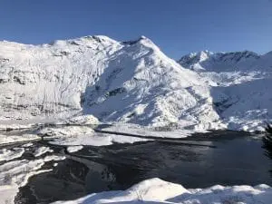
Photo of the Week
Happy Spring!
Announcements
The avalanche hazard is Low at all elevations. Old wind slabs and crusts exist in most areas. These old wind slabs have locked up and have been unreactive since 3/25. Pockets of windslab could still be triggered in continental locations at upper elevations where they rest upon faceted snow. Cold temperatures and wind will limit wet loose activity 3/29. Stay clear of cornices and avoid exposing yourself to terrain traps.
