Valdez
Above 4,000ftModerate
2,000 to 4,000ftModerate
Below 2,000ftModerate
Degrees of Avalanche Danger
Avalanche Problems
Problem 1

Likelihood:
- Almost Certain
- Very Likely
- Likely
- Possible
- Unlikely
Size:
- Historic
- Very Large
- Large
- Small
Trend
- Increasing
- Steady
- Decreasing
Problem 2

Likelihood:
- Almost Certain
- Very Likely
- Likely
- Possible
- Unlikely
Size:
- Historic
- Very Large
- Large
- Small
Trend
- Increasing
- Steady
- Decreasing
Avalanche Activity
2/28: Natural wind slab avalanche 4000′. N-HS-R2-D2, West aspect slope that descends from crud buster basin into iguana backs. Stepped down immediately below initial crown, to the ground in places.

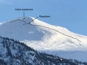
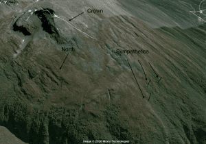
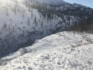
2/26: Large natural observed at 48 mile off point 5064 “stuart”. N-HS-R3-D3, N-W aspects. Observed from the highway. Looked fresh, probably within the last 24 hours. Appears to have released from a N aspect bowl ~40-45° at~4500′, then stepped down and wrapped around the corner onto NW-W aspects. Crown on step down is estimated to be over 3 meters deep in places. Couldn’t see extent of track length. Crown was over 1/2 mile wide. 3 small Sympathetic pockets were observed over 1/2 mile away in moderate terrain with crowns ~1-2 meters. Picture taken from over 3 miles away.
2/24: Natural avalanche observed on the North face of Goodwills’ ~5500′, D-2.5, 200-300′ wide ran to the bottom of the slope ~600′, crown ~5′ deep.

2/23: – Natural avalanches D2-2.5 on the east face of Mt. Tiekel were observed.
- At the headwaters of Quartz creek, MP 54 a large group of snowmachiners potentially remotely triggered a D2 avalanche. See observations page.
2/21: Multiple natural and human triggered avalanches were observed 2/21.
- A natural avalanche hit the road near 39 mile. This natural originated from mid slope elevations and put a small amount of debris onto the road. DOT mitigation efforts produced a D 3.5 avalanche that originated from the upper mountain ~6000′ and stepped down multiple times. Crown depths were reported being significant. Debris 6-15 feet deep buried 1000′ of the Richardson highway.

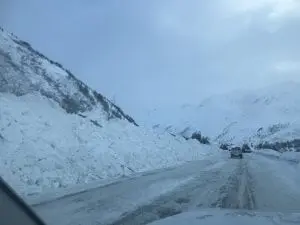
Debris along the highway after DOT cleanup work.
Debris that over ran the highway and was deposited into the Tsaina Gorge.
- A natural released at the toe of Worthington Glacier on a slope just south of the toe on a north east aspect. Crown was over 400′ wide and crown depth averaged 3-5 feet and stepped down to over 10′ deep at one point. There was a small sympathetic associated as well.
- A small deep pocket (50′ across ~4′ deep) was observed on the East side of the highway below gully 1 that was remote triggered by snowmachines high marking above.
- Two small avalanches released off a south slope above the airstrip with unknown trigger. Many snowmachine tracks were present in the area around the slides.

Natural near the toe of the Worthington glacier.
2/20: Two side by side avalanches were observed on the NW shoulder of the Python buttress ~3500′. Crown 2-300′ across and ~3’+ deep, these slides ran into the flat ~800 vertical feet. These slides were triggered by DOT mitigation work 2/19.
2/20: 2 paths on Three Pigs at mp 42 slid naturally to the middle to lower portion of their aprons, D2.5. Low clouds prevented ability to see what elevation they originated from.
2/20: A Natural avalanche was reported on the north shoulder of Mt Tiekel at ~4500′. Details were limited but the entire slope avalanched and crown was reported to be 2 meters deep. R5-D2.5~.
2/19: A Natural avalanche at 32 mile buried the Richardson higway under 10 feet of snow for ~100′. This caused the highway to close for the majority of the day. Details on the slide were limited due to poor visibility on 2/19.
2/14: Dry loose D1-2 natural avalanches were observed running over the wowie zowie ice climb in Mineral creek.
2/13: Natural and human triggered D1 avalanches were observed in keystone canyon.
2/12: A D3 avalanche at mile post 38 hit the Richardson highway and closed the road. Released on a south aspect in the upper elevation start zones, ~5500′, and stepped down around 4-4500′. Further DOT mitigation efforts on Three pigs and 40.5 mile produced no results.
2/11: Small avalanche observed on NW aspect of Dimond “promise land”, ~5500′ , R1-D1.5, wind loaded pocket just off ridge line.
-Several avalanches observed on steep benches below 2500′ on S aspect hippie ridge around MP 35. Only ran height of bench ~100′, but had long connected crowns suggesting these failed on a Persistent weak layer. Crowns ~2′ deep.
2/10: Skies cleared yesterday, from 46 mile to Thompson Pass very few natural avalanches were seen from the 27 inches of snow that fell from 2/8- 2/10.
2/8: Many full path avalanches were reported running around Valdez glacier lake.
2/6: 2 remote triggered avalanches on RFS at 1800-2000′.
- SS-ARr-R1-D1-O, N aspect, 60′ wide, 50 cm crown, 1800′, failed on buried near surface facets.
- SS-ARr-R3-D1.5-O, N aspect, 100′ wide, ~60 cm crown, 2000′, failed on buried near surface facets.
Photo of 1st remote trigger listed

-Natural avalanches observed on south aspect at mile 40, ~1800′, 1-2 feet deep and ~100′ wide. SS-NL-R2-D1.5-O. These were triggered by small snow sluffs.

2/2: Numerous Small pockets of unsupported terrain released naturally in the tsaina valley below 2000′, 2′ deep.

1/27-1/30: Naturals were observed on RFS, N aspect ~6000′,

Avalanches were also observed on -40.5 mile, ~5000′ ,W aspect, 60 m crown
– 2 paths on Three Pigs, ~5000′, SE aspect, ran into the top 1/3 of aprons.
– 3 slides on Billy Mitchell ranging from 3000′-6000′, NW- N aspect. The most significant was on the upper bowl of cry babys, ~5000′, ~200 m crown, 1-2 meters deep.
1/23- Found fresh debris in a gully off point 3848′ behind the airport. D2, ran ~2000′.
~ 1/10- There have been several natural windslabs that have released in the Thompson Pass region:
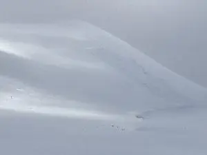
-South slope of catchers mitt, near 27 mile icefall,~3500′, ~300m wide ,~3′ deep, ran 500′ HS-N-R3-D2.5. Photo shows extent of crown, which may have been bigger and is now filled in by wind transported snow.

Weather
2/29- Clouds will be increasing through the day and winds will shift from north east to the south ahead of the next weather front. Snowfall will begin tonight for our area with light to moderate accumulations expected overnight.
The Thompson Pass Mountain Forecast covers the mountains (above
1000 ft) surrounding Keystone Canyon through Thompson Pass to
Worthington Glacier.

This forecast is for use in snow safety activities and emergency
management.

                   Today        Tonight

Temp at 1000`      23 F         21 F

Temp at 3000`      17 F         21 F

Chance of precip   60%          100%

Precip amount
(above 1000 FT)    0.02 in      0.30 in

Snow amount
(above 1000 FT)    0 in         3-6 in

Snow level         sea level    sea level

Wind 3000` ridges  S 5-11 mph   S 8-15 mph

Remarks...Snow totals of 1 to 2 feet with 1 inch of QPF are
possible tonight into Monday.
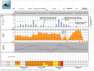
| 24h snowfall (inches) | HN24W (inches)* | Hi Temp (F) | Low Temp (F) | February snowfall | Season Snowfall | Snow height | |
| Valdez | 0 | 0 | 31 | 5 | 45 | 152 | 62 |
| 46 mile | 0 | 0 | 22 | -14 | 32 | 93 | 31 |
|
Thompson Pass “DOT” |
0 | 0 | 14 | – | 114 | 491 | 90 |
HN24W= total water received last 24 hours in inches
Thompson Pass weather history 19/20 season beginning 12/21 through 1/23. Click on links below to see full size image.


Additional Information
Strong north east winds have affected our area building wind slabs and further stressing weak layers deep within our snowpack. Numerous natural avalanches have occurred since 2/19, most of these have happened north of mile post 32.
Our area has received up to 4′ of snow with strong south east- south west winds since 2/17.
This new snow fell on a spatially variable snowpack. Some areas have very poor structure with problem layers buried deep within the snowpack. Other areas do not have this problem. Generally, weaker snowpacks have been found the further you move north from Thompson Pass.
In areas that did not slide 2/19-2/23, weak layers deep in the snowpack still exist. These weak layers will be difficult to affect due to their depth, but would produce very large, deadly avalanches if triggered.
Forecast Confidence is Moderate.
Resolution is Low
There have been limited observations from interior locations due to low snow at lower elevations. Use caution if you travel in these areas.
If you see something in the mountains that could contribute to this forecast, leave a public observation. The more observations we receive, the better we can tune our forecast. If you would rather not post an observation publicly, feel free to send me an email at gb****@********ow.org
Send in your best mountain recreation photos to gb****@********ow.org so we can post a photo of the week!
Photo of the Week
Thanks to Spencer Byson for sending in this photo!

Announcements
The avalanche hazard is Considerable at all elevations. The Continental zone has a very weak snowpack with dangerous persistent weak layers buried deeply. These layers still have the energy to produce very large avalanches. This has been demonstrated by numerous D2-3 natural avalanches occurring as late as 2/26. Avoid terrain traps and large slopes above 30°.
Be aware that the forecast zones have been adjusted. The northern extent of our forecast area is now at Stuart creek on the west end of the Richardson and the Tiekel river valley on the east side of the highway. This avalanche forecast is not valid north of mile post 46. Observations for this area will still be made when available.