Valdez
Above 3,000ftConsiderable
1,500 to 3,000ftConsiderable
Below 1,500ftConsiderable
Degrees of Avalanche Danger
Avalanche Problems
Problem 1
A strong winter storm will be affecting our area on 12/ 6 with additional snowfall of 12-16 inches along with moderate to strong southerly winds. Increasing temperatures during the last 24 hours have been significant with the Tsaina snotel going from -20 to 20 above in 24 hours! All of this combined weather will be adding stress to a weak snowpack. It will be likely that storm slabs will be reactive to human triggers in terrain steeper than 35°. This will be especially true in convex or wind loaded terrain. Avoid large avalanche paths and runouts.
A greater concern will be storm slabs stepping down into persistent weak layers deeper in our snowpack and creating larger more destructive avalanches.

Likelihood:
- Almost Certain
- Very Likely
- Likely
- Possible
- Unlikely
Size:
- Historic
- Very Large
- Large
- Small
Trend
- Increasing
- Steady
- Decreasing
Problem 2
Very weak snow exists in our snowpack buried 1.5-2 feet in depth. This weak snow (facets) are being stressed by new snowfall, wind and rising temperatures. If our area receives the forecasted 2-3 feet of snow out of this storm it is possible that these layers will fail naturally. Wether they fail naturally or not, human triggered avalanches will be likely that could injure, bury or kill a person.
Photo of 1cm+ chained facet found buried 40 cms (16″) on Catchers Mitt 3500′ SE aspect.


Likelihood:
- Almost Certain
- Very Likely
- Likely
- Possible
- Unlikely
Size:
- Historic
- Very Large
- Large
- Small
Trend
- Increasing
- Steady
- Decreasing
Avalanche Activity
12/2-12/3- Several natural D2 avalanches were noted on south aspects of Three pigs, Hippie Ridge and Averys. These windslab avalanches originated between 4000-5500 feet elevation.

Weather
NWS Watches and Warnings
Northeast Prince William Sound-
Including the cities of Valdez and Thompson Pass
446 AM AKST Mon Dec 6 2021
...WINTER STORM WARNING REMAINS IN EFFECT UNTIL 6 PM AKST
TUESDAY...
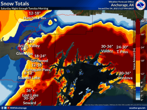
* WHAT...Heavy snow occurring. Total snow accumulations of 16 to
30 inches.
Point forecast for Thompson Pass
Detailed forecast for Thompson Pass (mid elevation 2000-4000′)
DATE MONDAY 12/06 TUESDAY 12/07
TIME (LT) 06 12 18 00 06 12 18 00 06
CLOUD COVER OV OV OV OV OV OV OV OV BK
CLOUD COVER (%) 100 100 100 100 75 75 70 85 55
TEMPERATURE 20 25 22 20 18 15 13 10 8
MAX/MIN TEMP 26 17 19 8
WIND DIR S S SE SE E NE NE NE N
WIND (MPH) 19 20 24 21 12 10 20 20 12
WIND GUST (MPH) 36 41 44 40 32 37 37
PRECIP PROB (%) 100 100 100 100 50 60 20 30 10
PRECIP TYPE S S S S S S S S
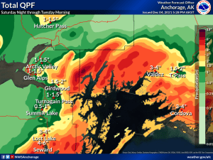
12 HOUR QPF 0.39 0.41 0.07 0.03
12 HOUR SNOW 5.4 5.9 0.1 0.0
SNOW LEVEL (KFT)0.1 0.0 0.1 0.4 0.3 0.0 0.0 0.0 0.0
Snow and Temperature Measurements
| Date: 12/06 | 24 hr snow | HN24W* | High Temp | Low Temp | Weekly SWE (Monday- Sunday) | December Snowfall | Season Snowfall | HS (Snowpack depth) |
| Valdez | 13 | .66 | 25 | 17 | .66 | 26 | 51 | 30 |
| Thompson Pass | 4-6″ | N/O | wx station down | wx station down | N/O | – | – | – |
| 46 Mile | Trace | 0 | 27 | -9 | 0 | 5 | 5** | 13
|
All snowfall measurements are expressed in inches and temperature in Fahrenheit. 24 hour sample period is from 6am-6am.
* 24 hour snow water equivalent/ SWE.
** Season total snowfall measurements for 46 mile began December 1st.
Season history graphs for Thompson Pass

Click on links below to see a clear and expanded view of above Season history graphs
Additional Information
Winter weather began early this season, with valley locations receiving their first snowfall on the last day of Summer (September 21st). Following this storm, above average temperatures and wet weather occurred from late September through early November. During this time period Thompson Pass received 96 inches of snowfall by November 7th and Valdez recorded 7.73″ of rain.
After the 7th of November our region experienced a sharp weather pattern change. Temperatures dropped below seasonal norms and snowfall became infrequent. Between the time frame of November 7th- November 28th Thompson Pass only reported 19″ of snow with 1.1″ of Snow water equivalent (SWE). Temperatures remained below 0° F for most of the period. This cold/dry weather caused significant faceting of the snowpack, with poor structure the result.
Moderate snowfall returned to our area the last day of November and deposited 6-12 inches of new snow. The amount varied depending upon the locations’ proximity to the coast. As the storm exited on the 2nd of December it was quickly replaced by moderate to strong northeast winds. This moderate outflow wind event resulted in the formation of wind slabs that were very reactive to human triggers. This is yet another sure indicator of the weaknesses present in our snowpack.
Announcements
Click the + Full Forecast button below for a list of current avalanche problems, travel advice, weather resources and more.
Help to improve your local avalanche center and contribute an observation to the website. You can also contact me directly at ga**********@ya***.com (907)255-7690.