Valdez
Above 3,000ftConsiderable
1,500 to 3,000ftConsiderable
Below 1,500ftConsiderable
Degrees of Avalanche Danger
Avalanche Problems
Problem 1
On 12/5 we will see a new windslab problem arise as heavy snowfall arrives with moderate to strong southerly winds. This will load different aspects and may quickly stress faceted layers in our snowpack. Even small avalanches may have the potential to step down to persistent deep layers and create large avalanches.
It is still possible to trigger older wind slabs created 12/2 on lee aspects. As of 12/4 smaller slopes had gained some stability and were stubborn to triggers. It may be possible for human triggered avalanches to occur on larger lee slopes. If initiated, avalanches would now propagate longer distances and may fail behind a skier or snowmachine once they have already entered the slope.
Pay attention to what the weather is doing today. Your level of caution should increase directly with the increase in winds and precipitation.


Likelihood:
- Almost Certain
- Very Likely
- Likely
- Possible
- Unlikely
Size:
- Historic
- Very Large
- Large
- Small
Trend
- Increasing
- Steady
- Decreasing
Problem 2
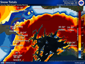
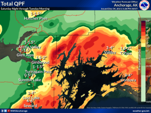
A strong winter storm is forecasted for our forecast area, with up to 3 feet of new snow expected along with rising temperatures in the next 72 hours. Areas near the coast are expected to receive the highest amounts of snowfall.
At the present moment we have very poor structure in the snowpack. We have thus far not seen a lot of avalanche activity aside from some recent natural wind slabs. The reason for this is that we are lacking one of the key ingredients for avalanches to occur- a cohesive slab. This situation is all about to change. Up to 3 feet of new snow along with rising temperatures will create this cohesive slab.
If we receive the forecasted 3 feet of snow or more, it is possible that the snowpack will be unable to support this new load and a natural avalanche cycle would occur. If we receive less than the forecasted amount, the snowpack may be able to hold on. What we would be left with, would be a very dangerous snowpack that is hanging on by its fingernails. Either scenario spells the same outcome of elevated avalanche hazard arriving with the onset of heavy precipitation sometime this afternoon/ evening. Avoid avalanche terrain during the storm.
Photo of 1cm+ chained facet found buried 40 cms (16″) on Catchers Mitt 3500′ SE aspect.


Likelihood:
- Almost Certain
- Very Likely
- Likely
- Possible
- Unlikely
Size:
- Historic
- Very Large
- Large
- Small
Trend
- Increasing
- Steady
- Decreasing
Avalanche Activity
12/2-12/3- Several natural D2 avalanches were noted on south aspects of Three pigs, Hippie Ridge and Averys. These windslab avalanches originated between 4000-5500 feet elevation.

Weather
NWS Watches and Warnings
Northeast Prince William Sound-
Including the cities of Valdez and Thompson Pass
514 AM AKST Sun Dec 5 2021

...WINTER STORM WARNING REMAINS IN EFFECT FROM 6 PM THIS EVENING
TO 6 PM AKST TUESDAY...

* WHAT...Heavy snow expected. Total snow accumulations of 16 to
  30 inches.
Point forecast for Thompson Pass
Detailed forecast for Thompson Pass (mid elevation 2000-4000′)
DATE             SUNDAY 12/05            MONDAY 12/06
TIME (LT)        06    12    18    00    06    12    18    00    06
CLOUD COVER      OV    OV    OV    OV    OV    OV    OV    OV    OV
CLOUD COVER (%)  85   100   100   100   100   100   100   100   100
TEMPERATURE      15    18    20    22    24    25    25    24    19
MAX/MIN TEMP                 20          19          26          19
WIND DIR         SE    SE     S     S     S     S    SE    SE     E
WIND (MPH)       12    17    23    21    20    21    21    17     8
WIND GUST (MPH)  29
PRECIP PROB (%)  70    90    90   100   100   100   100   100   100
PRECIP TYPE       S     S     S     S     S     S     S     S     S
12 HOUR QPF                0.17        0.42        0.39        0.44
12 HOUR SNOW                2.8         6.1         5.2         5.7
SNOW LEVEL (KFT)0.0   0.0   0.0   0.1   0.1   0.1   0.2   0.1   0.1
Snow and Temperature Measurements
| Date: 12/05 | 24 hr snow | HN24W* | High Temp | Low Temp | Weekly SWE (Monday- Sunday) | December Snowfall | Season Snowfall | HS (Snowpack depth) |
| Valdez | Trace | 0 | 18 | -2 | .54 | 13 | 38 | 17 |
| Thompson Pass | N/O | N/O | wx station down | wx station down | .9 | 11 | 130 | 30 |
| 46 Mile | 0 | 0 | -7 | -17 | .32 | 5 | 5** | 12
|
All snowfall measurements are expressed in inches and temperature in Fahrenheit. 24 hour sample period is from 6am-6am.
* 24 hour snow water equivalent/ SWE.
** Season total snowfall measurements for 46 mile began December 1st.
Season history graphs for Thompson Pass

Click on links below to see a clear and expanded view of above Season history graphs
Additional Information
Winter weather began early this season, with valley locations receiving their first snowfall on the last day of Summer (September 21st). Following this storm, above average temperatures and wet weather occurred from late September through early November. During this time period Thompson Pass received 96 inches of snowfall by November 7th and Valdez recorded 7.73″ of rain.
After the 7th of November our region experienced a sharp weather pattern change. Temperatures dropped below seasonal norms and snowfall became infrequent. Between the time frame of November 7th- November 28th Thompson Pass only reported 19″ of snow with 1.1″ of Snow water equivalent (SWE). Temperatures remained below 0° F for most of the period. This cold/dry weather caused significant faceting of the snowpack, with poor structure the result.
Moderate snowfall returned to our area the last day of November and deposited 6-12 inches of new snow. The amount varied depending upon the locations’ proximity to the coast. As the storm exited on the 2nd of December it was quickly replaced by moderate to strong northeast winds. This moderate outflow wind event resulted in the formation of wind slabs that were very reactive to human triggers. This is yet another sure indicator of the weaknesses present in our snowpack.
Announcements
Click the + Full Forecast button below for a list of current avalanche problems, travel advice, weather resources and more.
Help to improve your local avalanche center and contribute an observation to the website. You can also contact me directly at ga**********@ya***.com (907)255-7690.