Valdez
Above 4,000ftConsiderable
2,000 to 4,000ftConsiderable
Below 2,000ftConsiderable
Degrees of Avalanche Danger
Avalanche Problems
Problem 1
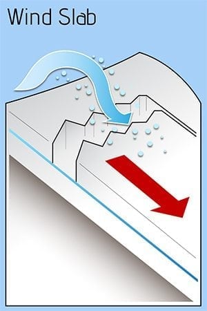
Outflow (NE) winds are forecasted to reach speed of 30 mph with gusts to 50 through Thompson Pass. This will be redistributing new snow onto lee aspects (SE-NW) that are already likely reactive to human triggers. The most likely places to encounter reactive fresh wind slabs will be on the lee side of high elevation ridge lines and cross loaded terrain. Shallow wind slabs may be able to step down to deeper persistent weak layers in the snowpack and create large destructive avalanches.
Likelihood:
- Almost Certain
- Very Likely
- Likely
- Possible
- Unlikely
Size:
- Historic
- Very Large
- Large
- Small
Trend
- Increasing
- Steady
- Decreasing
Problem 2
A lot of spatial variability exists in our forecast area from the Port of Valdez to MP 46. In many areas a faceted mid and lower snowpack exists. The further you move from the coast, the weaker the snowpack becomes generally speaking.
The last weak of March saw a fair number of shallow skier triggered avalanches. These were generally less than a foot deep and were made up of cohesive wind slabs overlying near surface facets. Moving forward we have now received a foot or more of new snow that will adding stress to an already reactive weak layer in our snowpack. Add in outflow winds and the strength of the early April sun and you have a dangerous set up. Choosing appropriate terrain will be paramount in having a safe day in the mountains today.
Photo of near surface facets from the Tonsina Valley on 3/22, down 15 cms.

Likelihood:
- Almost Certain
- Very Likely
- Likely
- Possible
- Unlikely
Size:
- Historic
- Very Large
- Large
- Small
Trend
- Increasing
- Steady
- Decreasing
Problem 3
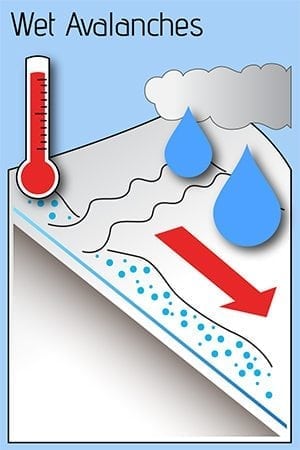
The latest storm snow will be easily affected by the sun on solar aspects. This was apparent on 3/31 in the Maritime zone where the mountains came alive with wet loose activity almost the moment the sun popped out. Expect the same to occur today. Avoid exposing yourself to big, steep solar aspects during the heat of the day. It is possible that wet loose avalanches could step down to deeper layers in the snowpack and create larger slab avalanches, especially in the Continental zone.
Areas were moderate to strong wind is occurring will likely limit wet loose activity as these slopes will remain colder.
Likelihood:
- Almost Certain
- Very Likely
- Likely
- Possible
- Unlikely
Size:
- Historic
- Very Large
- Large
- Small
Trend
- Increasing
- Steady
- Decreasing
Avalanche Activity
3/31- D3 natural avalanche was reported in Snowslide Gulch
Significant wet-loose activity was observed on solar aspects in the Maritime zone.
3/28- A skier triggered avalanche was reported on Billy Mitchel/38° slope/ north/ 3700′.
3/28- A natural D3 avalanche was reported on Sweetie Pie ( backside of Eater Bunny). Avalanche was triggered by cornice fall and chunks of debris were reported to be the size of snow machines. Crown depth was not reported due to poor light although the flanks were reported to be at least 4 feet deep in spots.
3/28-An observer reported a skier triggered avalanche while ski cutting above a gully in Tiekel Trees. ~2800’/ East/ up to 18 inches deep/ 35-40′ wide/ SS-ASc-D2-R2-O. This incident occurred outside of our forecast zone but is a good indication that a persistent slab problem exists.


3/24- Allison Creek snowmachine triggered D2. South aspect/ 4500’/ Less than 1 foot deep, 100 feet across, and ran for 200′. Occured on a 40-45° convex roll. Rider was able to ride away from the slide.

3/22- Heli skier triggered avalanche, Sharp Peak, 5.5K, East. SS-ASu-R2-D2-O. 60m wide x 40cm – 1m deep. 34* start zone. Sixth skier on slope, caught and carried. No burial or injuries. Failure occurred on 3mm depth hoar over a 2cm crust, and the ground.


3/20- Skier triggered avalanche was reported on the Hoodoo Glacier. Elevation unknown/ NW aspect/ crown~ 1 foot/ ~100′ wide. Skier was caught and carried but not buried or injured.
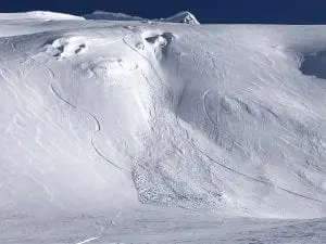
3/19- A natural D2 avalanche was observed in Solomon Gulch on a west aspect. Crown was ~100′ wide/ 3-4 feet deep/ originated at~2100′ with some of the debris running 1500′ to the valley floor while the majority stopped a bit short.

3/15- Snowmachine triggered hard slab avalanche on Little Girls SE aspect/ 3500′. Crown was reported at 6 feet, ~200 meters wide. Snowmachine was buried, it is unclear if the person involved was partially buried.


3/14-17- Multiple small human triggered avalanches have been reported on the 3/9 buried surface hoar/ near surface facet layer on a variety of aspects at mid and upper elevations. These have all occurred in areas where wind slab or stiffened storm snow was present.
3/4- A human triggered avalanche was reported on Billy Mitchell while a group was bootpacking. NW aspect/ ~4500’/ Crown depth was 3′ and wrapped around a corner of terrain for another ~300′. No one was caught, hikers were able to run off of the slab.
3/3- Observed an avalanche in The Books, that I’m assuming was skier triggered. NW aspect/~5500’/ran ~800′ vertical. Crown looked less than a foot deep but included nearly the entire start zone. No other details available.

2/28- 2 skier triggered D1’s in the Approach Couloir of Billy Mitchell. ~3800′, NE aspect, ~80′ wide, ~8″ deep and ran 300′ vertical. Remote trigger also occurred at the bottom of the couloir in mellower terrain pulling out a smaller, but deeper pocket in adjacent rocky terrain, ~20″ deep.
Several D1 skier triggered wind slabs were also reported in the Dimond ramps on west aspects.
2/25- Spring arrived on 2/25 with numerous point release wet loose on SE-SW aspects at all elevations and in all forecast zones. Point releases caused some small storm slabs to pull out in some locations as well.


2/20-Natural D2 wind slab avalanche was observed on the lower bench of Catchers Mitt. SE aspect/~2700′. Crown depth and width were not observed due to wind refill. Ran ~300′ with a 100′ wide deposition zone. HS-N-D2-I
2/17- A D 2 natural was observed off steep north facing terrain on Benzene peak that ran 800′. Several small natural D1’s were observed in Benzene Alley on convex terrain features. These all ran on the 2/1 wind board.

2/13- No natural or human triggered avalanches have been observed or reported since 2/1. Thompson Pass has received only 1 inch of SWE in the last 3 weeks.
2/1- Natural avalanches from the 2/1 outflow event were noted on Hippie Ridge in cross loaded gullies SW aspect/ D2’s ~4000’/ depths were difficult to gauge because crown were rapidly being filled in by wind deposit.

-Slides were also noted on Averys: SW/~3500’/ ~300′ wide/ D2
40.5 Mile Peak:W-N/~3500’/ 3 separate D2’s/ ~200-300′ wide
As stated above depths were difficult to gauge due to wind refill. A report did come in of 3′ crowns on the west aspects of the Mt. Dimond moraines/ ~4000’/ ~300′ wide
Many other avalanches likely occurred but observation was limited due to wind refilling crowns.
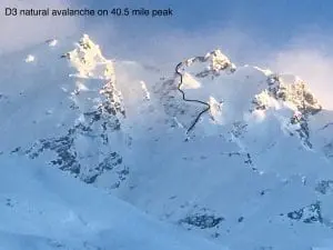
1/27- The photo below shows a natural D3 avalanche that was reported on 1/30. It is uncertain when this avalanche occurred. It most likely happened during the 1/26 wind event. 40.5 Mile Peak/ NW aspect/ full depth, 3+ meters / ~800′ wide/6000′. Demonstrates that basal facets are still a player in our continental zone.
-Natural D2 avalanche observed at 42 mile in a cross loaded south facing gully.

1/18-19- Numerous wet loose slides occurred region-wide below 2000′.
Schoolbus had a natural avalanche affect the highway early 1/19 that covered the road with 2′ of debris for ~100′.
DOT mitigation efforts produced avalanches at Snow Slide Gulch, Ptarmigan Drop (Nick’s Buttress), Python Buttress, Three Pigs and 40.5 Mile peak.
The most notable slide occurred at Ptarmigan Drop and Python and deposited 6′ of snow on the highway for 150′ of road length. Crowns failed at ~3500′ and were extensive, connecting almost the entirety of the Nicks’ through Python Buttresses. The western extent of Nicks stepped down to the ground in an area that failed full depth 12/1. Nearly a mile of terrain was effected with some crowns approaching a quarter mile in length.

It is unclear how much of the activity at Three Pigs and 40.5 Mile was natural versus artillery triggered, but there were multiple paths leaving debris at the bottom of run outs.
1/15- Two natural D2 avalanches observed on a NW aspect of RFS, crown~ 3′ deep.

1/9- Natural avalanche observed on an east aspect of North Tiekel. Likely failed during warmup the night of 1/8. Avalanches failed at terrain convexities around 3500′. This area is 4 miles north (beyond) our Continental forecast zone, but is still indicative of that zone.

1/8- 3 separate skier triggered avalanches on Cracked Ice at 2800’/ 40 cms deep (16 inches)/ 100-300′ wide/ ran 600-700 feet and failed on the 1/3 buried surface hoar layer. SS-AR-U-D1.5-2-O

Lower section of far lookers left crown.

12/24- Observers reported remote triggered avalanches up to 100 meters away that were a meter deep. Tsaina trees below 3000′.
12/23- DOT mitigation work on snow slide gulch produced 3 D2.5’s that ran half of their path.
– HS-N-R3-D3-G, NW Crudbusters/ ~5000′

-Multiple D2-D2.5 slides on Oddessey and Little Oddessey. NW-N aspects. Only Little Oddessey crown was clear. ~100 yards wide, ~4′ deep.

-Natural D3 avalanche on Billy Mitchell NW-N aspects, originated ~5000′ stepped down to the ground around 4200′ in rocky terrain. Approximately 200 yards wide.
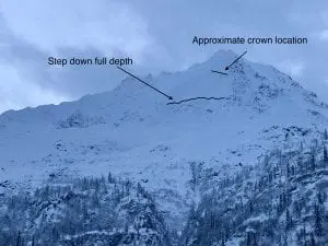
-Natural D2 avalanche activity was also noted on west aspects of 40.5 mile and Iguana Backs ~3500′. Further observations were prevented due to poor light.
12/20- A powder cloud reached the highway at the mp 42 slide path. “Three Pigs”. No other details available
-Numerous small (3-4″ deep) natural avalanches were observed in the Python and Cracked Ice Buttress area.

12/20- Multiple D1 soft slabs off Mt Cheddar Cheese Wedge (Hippie Ridge) originating from ~6500′

12/3- Numerous natural avalanches were observed north of Thompson Pass with many avalanches failing at the ground. Observations were not made south of Thompson Pass.
Avalanches observed from 46 mile towards Thompson Pass:
Three Pigs: Nearly every path on the SE face ran with debris deposits stopping in the top 1/3 of aprons, thick alders prevented slides from running full path. These were mostly D3 avalanches.
40.5 Mile Peak: Many paths running similar to Three Pigs, with one running full path to the Tsaina river. Mainly W-NW aspects, D3’s
Max High (Peak on the southern extent of Hippie Ridge) had a D3 avalanche with a crown near 5500′,SW aspect.
Upper Catchers Mitt bowl E aspect, slid R4-D3 ,triggering further avalanches lower down.
The main activity noted, was on the buttresses on the east side of the pass, from Cracked Ice through North Odessey Gully. Every buttress had significant avalanche activity originating ~4000-5000′. Many of these failed at the ground, north – northwest aspect. Pictures below.
School Bus and North Odyssey Gully both ran with debris in the runouts.
Many other large to very large natural avalanches occurred.


12/2- DOT reported a natural D2.5-3 avalanche that hit the Lowe river at Snowslide Gulch.
11/30- Natural avalanche observed on 40.5 mile peak just to the South of the Shovel. West aspect, ~4500′, crown ~200′ wide, poor light prevented further observation. SS-N-R1-D2-U.
11/29: Natural avalanche observed on Billy Mitchell Cry babys shoulder, similar elevation as 11/16 slide but originated a couple hundred meters further west. Released from ~4000′ with a crown length of ~ 200 meters, North aspect, ~ 37°, failed at the ground. HS-N-R2-D2.5-G

11/16: Natural avalanche observed on Billy Mitchell “Cry babys shoulder”. Released from~3500′ with a crown length of ~200 meters, North aspect. This slide was triggered by recent NE wind cross loading the slope. SS-N-R2-D2-U
11/15: Natural avalanche observed in Loveland Basin on a South aspect, down the ridge from Tones Temple. This slide was triggered by recent NE wind loading and failed at the ground. SS-N-R1-D2-G
Weather
4/1- Decreasing clouds with moderate outflow winds.
The Thompson Pass Mountain Forecast covers the mountains (above
1000 ft) surrounding Keystone Canyon through Thompson Pass to
Worthington Glacier.

This forecast is for use in snow safety activities and emergency
management.

                   Today        Tonight

Temp at 1000`      33 F         16 F

Temp at 3000`      12-19 F      11-19 F

Chance of precip   0%           0%

Precip amount
(above 1000 FT)    0.00 in      0.00 in

Snow amount
(above 1000 FT)    0 in         0 in

Snow level         sea level    sea level

Wind 3000` ridges  NE 15-30 mph NE 17-35 mph

Remarks...None.
| Date: 4/1 | 24 hr snow (inches) | HN24W (snow water equivalent inches) | High Temp (F) | Low Temp (F) | Weekly SWE Inches (Monday-Sunday) | April snowfall | Season snowfall | HS (snowpack depth inches) |
| Valdez | 0 | 0 | 41 | 19 | 1.06 | 0 | 223 | 58 |
| Thompson Pass | 0 | 0 | 26 | 20 | 1.1 | 0 | 449 | 83 |
| 46 Mile | 0 | 0 | 36 | 22 | N/O | 0 | 133 | 48 |
NRCS water survey results 2/27
| Location | Snow Depth (inches) | Snow water equivalent (inches) |
| 37 Mile Bridge | 50 | 13.2 |
| Worthington Airstrip | 72 | 15.6 |
| 18 mile | 52 | 13 |
| Valdez Ball Fields | 53 | 11.2 |
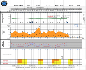
Thompson Pass weather history 20/21. Click on links above the images to see full size view


Additional Information
Our season began with a cold, dry and windy November which promoted faceting in the thin snowpack that existed. Only 28 inches of snow were recorded at Thompson Pass from 11/1 through 11/24.
November 25 began a series of storms that deposited 90” of snow and 11.1” of SWE on Thompson Pass at road level in an 8 day period. At the tail end of these storms the pass received 25” of snow and 3.7” of SWE in 48 hours, along with rising temps that pushed freezing line up to 3000’. This sparked a widespread natural avalanche cycle that failed on faceted snow created in early November. Many of these slides failed at the ground. See avalanche activity section for pictures of the cycle.
December continued with fairly regular snow fall and a couple periods of stable (dry) weather, with snowfall totaling 120 inches on Thompson Pass. Another, smaller natural avalanche cycle occurred on the 12/22 after Thompson Pass received 44 inches of snow with 4” of SWE in a 4 day period. Two full-depth naturals occurred in the Continental region on NW-N aspects between 4500-5000’ on NW Crudbusters and Billy Mitchell. Various other soft slab D2’s occurred in other regions as well. This indicated that depth hoar is still a concern in the Continental region but is becoming less so in our Maritime and Intermountain regions. Incremental snowfall during the second half of December has allowed the snowpack to slowly gain depth and strength.
Cold, stable weather at the end of December created widespread areas of surface hoar up to 1 cm in height, observed on all aspects between 2000-4000’ and up to ridge lines in isolated locations. This layer was more concentrated on the north side of Thompson Pass, promoted by colder temperatures and an ice fog layer that was forming during this time frame. However, this surface hoar has been reported in the Port of Valdez up to brush line.
1-3 feet of snow has since accumulated on top of this weak layer from 1/3-1/17.
A significant change in weather arrived on 1/18 delivering as much as 5″ of water to low lying areas with over 2 feet of snow accumulating above 2000′ accompanied by strong southeast winds. This prompted a natural avalanche cycle with the mid elevation band seeing the most activity.
Outflow winds have begun to affect our area beginning 1/26. This event was not widespread with many areas remaining protected. A major outflow event with speeds up to 80 mph on 2/1 had a more widespread affect on our area than the 1/26 event. Windward slopes were scoured and hard wind slabs were built on lee aspects. Once the dust settled surface snow ranged from exposed ridges blown to ground, sastrugi and very hard wind slabs. Numerous small to moderate natural avalanches occurred during the event.
On 2/2 Thompson pass received a foot of 5% density snow (very low density). This new snow rests on a very hard bed surface and has been slow to bond. Numerous point releases and sluffs have been observed in terrain steeper than 35°.
On 2/9 our area received an additional 10-16 inches of 4 % density snow, this has added to the depth of snow that is resting upon a hard bed surface.
In areas that were protected from the 2/1 hurricane force winds a freezing fog crust exists 40 cms down, up to 5000′. Small facets are forming above and below this crust and may become a concern in the future…
In the time period 1/25-2/15 Thompson Pass has recieved ~1″ of SWE and Valdez ~.6″. This has caused faceted snow to form in our mid snowpack.
Our drought ended on 2/16 with the coast receiving 18 inches of new snow and Thompson Pass 6-10 inches. Outflow winds rapidly returned with new snow being stripped from windward slopes and deposited onto lee aspects on Thompson Pass. In exposed terrain below 2500′ winds have stripped surfaces down to the 1/19 rain crust on windward aspects.
Cold/Dry weather over the last month has created small facets beneath old wind slabs and the 1/19 rain crust. Up to this point there has been an insufficient amount of stress on these layers to produce avalanches.
Several additional small – moderate shots of snow fell between 2/22 and 3/2 adding stress to near surface facets created in February.
On 3/3 NE winds ramped up to strong on Thompson Pass building windslabs on lee aspects. Several heliskiing and ski touring shallow wind slab avalanches were reported. These failed on near surface facets created in February. One deeper persistent slab avalanche was reported on Billy Mitchell as well.
The first week of March brought clear and cold weather, creating faceted snow at the surface. This layer was buried on 3/9 by a foot of snow which was quickly followed by a strong outflow event with gusts up to 74 mph recorded. This event produced multiple small skier triggered avalanches at the 3/9 interface.
Our area received an additional small to moderate shot of snow on the 15th followed by more outflow winds on the 16th and 18th-19th.
Shallow wind slabs have remained reactive in our forecast area with multiple small skier triggered avalanches being reported.
Snowpack structure generally becomes thinner and weaker as you move north from Thompson Pass
Announcements
The avalanche hazard is Considerable at all elevations. Human triggered avalanches up to 2 feet in depth are likely. Multiple factors have come into alignment to produce dangerous avalanche conditions. Thompson Pass reported a foot of new snow from the 3/30 storm, with higher amounts likely towards the coast and at upper elevations. This new snow has fallen on a faceted snowpack and will be initially reactive to human triggers. Moderate NE wind and a strong April sun will only be adding stress to an already dangerous set up. Make conservative terrain choices today and keep in mind that stability will likely vary from place to place. Avoid recently wind loaded slopes and terrain with consequences.
For more information click the (+full forecast) button below.
Help to improve your community avalanche forecast! Visit our observation page to leave a comment or you can email or text me at ga**********@ya***.com/ 907-255-7690
