Local Avalanche IncidentsMarch 13th, 2019 - Lake Chutes at "Mumford's", Haines, Alaska
Details of the Incident: (updated 3/20/2019) Location (closer/detailed map in the Terrain section below):
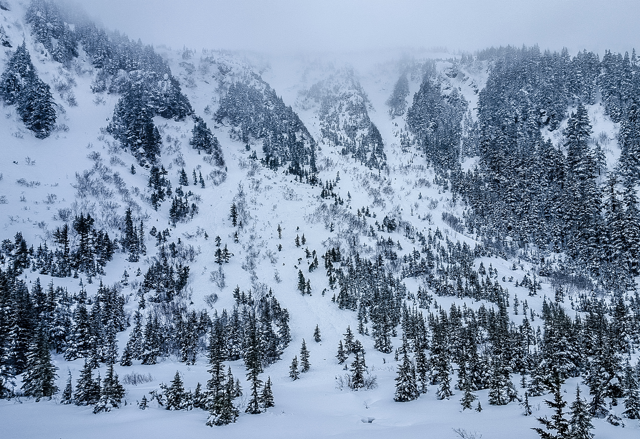
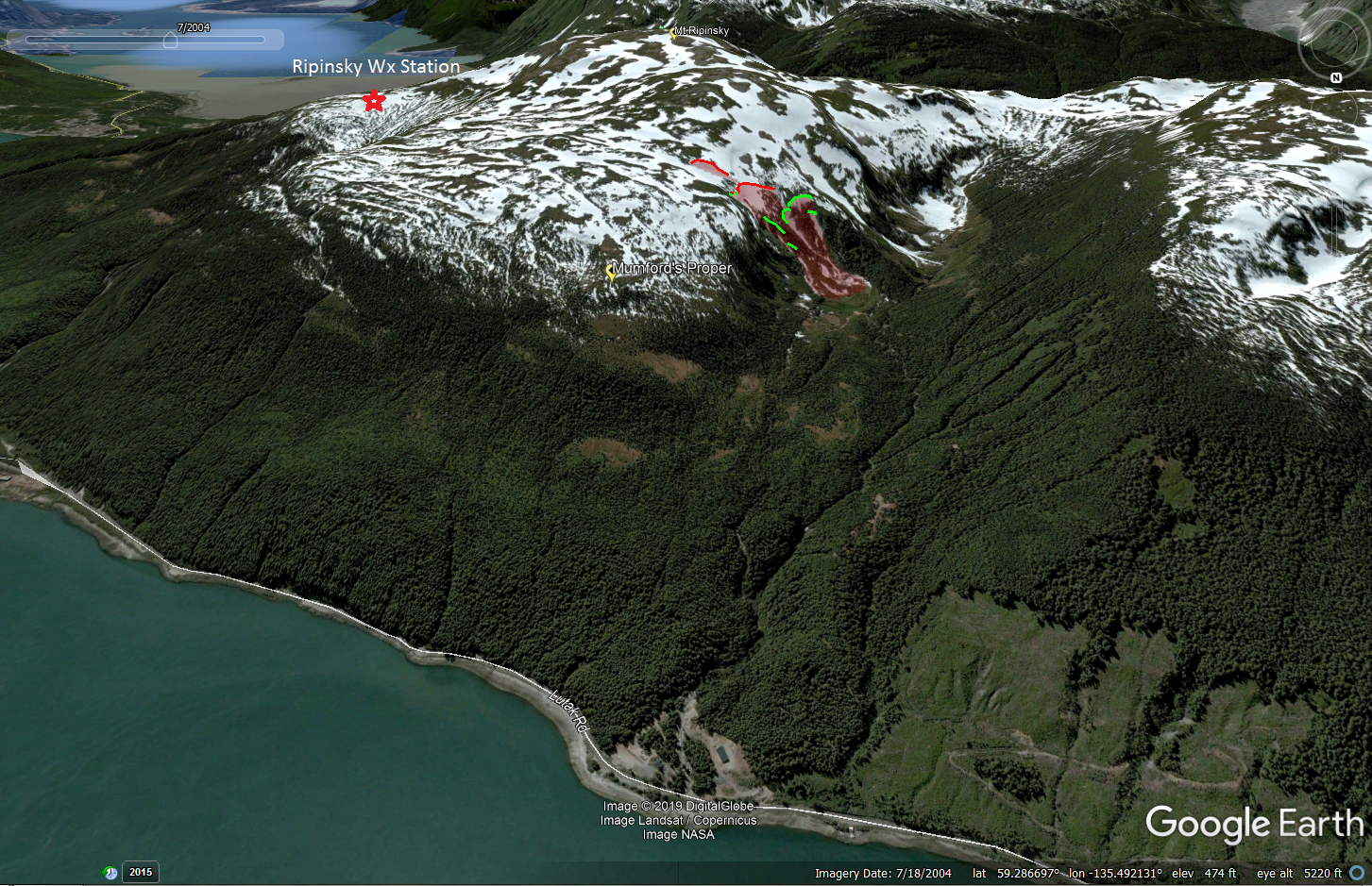 The avalanche occurred in and above the three main chutes that loom above the lake at the end of the Takshanuk Mountain Trail road (See maps above and below). This area, including the chutes, is easily accessed via state land and is commonly skied. We have multiple reports of people skiing these chutes this year without incident. The avalanche was very complex, with remarkable propagation across entire bowls, through stands of trees, including multiple chutes, aspects, and slopes. In general, it appears the entire area slid out, to varying depths. Linking together the upper crown lines across the path, the crown length maps out to approximately 400m. A second slide (included on map) that appears to be sympathetic occurred approx. 100m uphill on a smaller convexity. Debris funneled into all three chutes, completely filling the runout below them. Debris piled up approx. 20ft deep on the flats at the lake. Much of the debris in the upper bowl consisted of large blocks of hard slab. Weather History:
In late November, two very warm storms created a hard and thick rain crust on top of the somewhat-thin snowpack, up to elevations of 5000ft. A few inches of new snow fell on top and then it froze solid. By early December the snow over this crust was facetted and buried, and this was our primary avalanche problem until early January. Natural slides on this slick and uniform crust were large, propagating widely.
 Heavy precipitation in late December helped build a deep, solid snowpack above this crust, and by mid-January we were no longer getting failures in snowpits on it. The facets above it had been somewhat rounded-out; strength had increased greatly. This layer was put to sleep for the winter. January was the least-snowy on record in Haines. February wasn't much better. It was cold, clear, and windy with NW arctic outflow for long periods. This drove a facetting process between various minor rain crusts in the mid-pack, and these facet-crust sandwiches persisted into March. There was a much-needed snowfall event on February 21st, when about 30cm of new snow fell in the Lutak zone. Very rapid surface-facetting took place over the following 7 days, turning this new surface powder into 20-30cm of loose, weak facets (2mm). (Henceforth named the "Thick" facets) There was a significant thaw Feb. 26-28th, when temperatures reached 46F at 4600ft, and stayed above freezing for 48+ hours. Sunshine was strong, and a wet slide cycle occurred on solar aspects (A note on melt water: during this thaw, melt water only penetrated 30cm or less below the surface. It is highly doubtful any was able to penetrate down to the deep Nov. ice crust, even on south aspects). During this time, north aspects stayed surprisingly cool, and the thick layer of surface facets persisted. Finally, Sunday March 10th brought 30-45cm of new snow in the Lutak zone, somewhat wet and heavy below treeline. There was a strong wind event, with south winds transporting large amounts of new snow onto the northerly aspects in the Mumford's zone. This was observed and noted by two different people at Mumford's on March 10th.
There was a break in the weather March 11th-12th, though moderate-strong south winds continued. There was some sun, and temperatures were warm, reaching above freezing during the daytime at 2600ft.
Data from the Mt. Ripinsky weather station (Elevation 2600ft, 1.5 miles to the Southeast of accident site) leading up to the accident (notice the slow warming trend, and the heavy snow / south wind event on March 10th). Day/time of accident marked with red arrow: 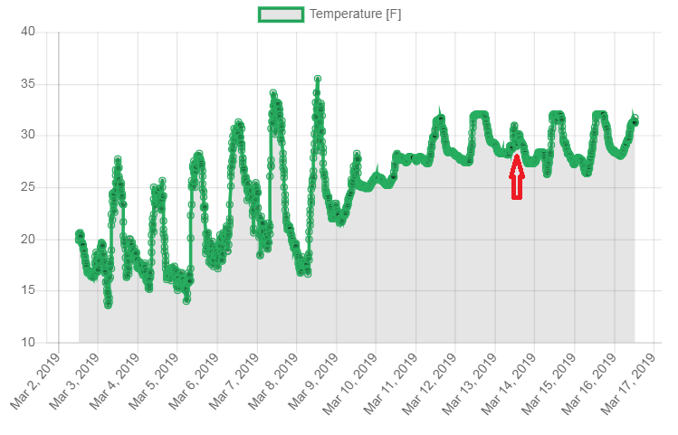 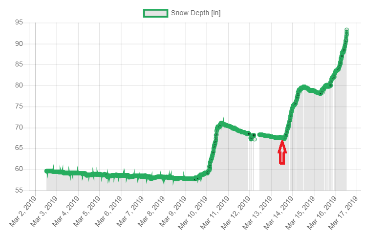 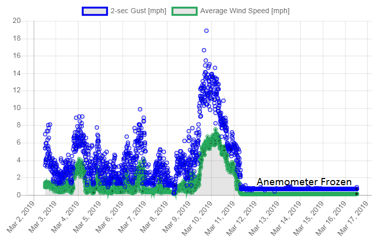 Note: Station is somewhat-protected from the wind by trees. A good rule of thumb is to double these wind speeds. 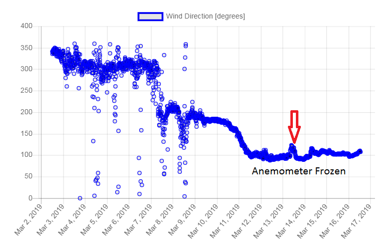 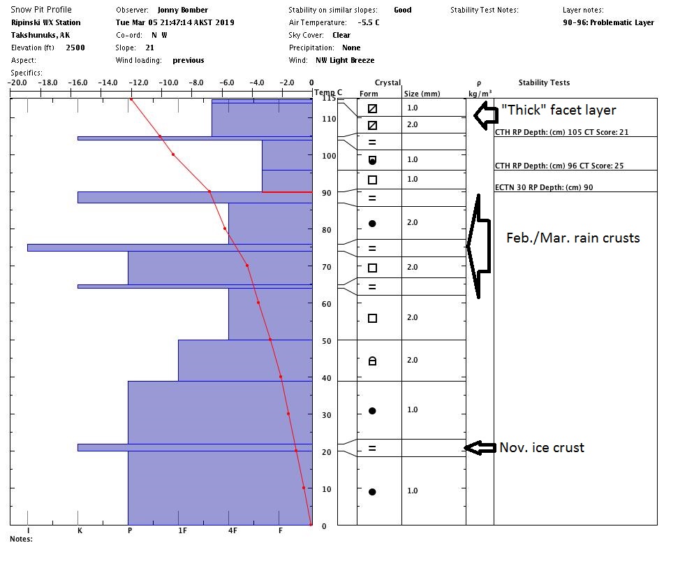 Snowpack: The area of the accident is somewhat of an anomaly, in that it collects extra-large amounts of snow during south-wind storms. Snow depths in the area above the chutes seemed to average about 3m, with some wind pillows perhaps 5m deep. There was a large amount of wind loaded snow from the storm on 3/10. The new storm snow had had a few days to settle and bond, but there was probably continued wind loading during this time. All this new snow was resting on the "Thick" facet layer. 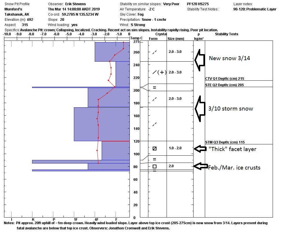 Below Image: Pit #2: from approx. 450ft above the main crown. In this location the snowpack structure was mostly the same, though with less wind loading of new snow in the top two storm layers. The top 40cm is new snow that fell 3/14, after the avalanche. Observers: Jeff Moskowitz and Austin Shannon. 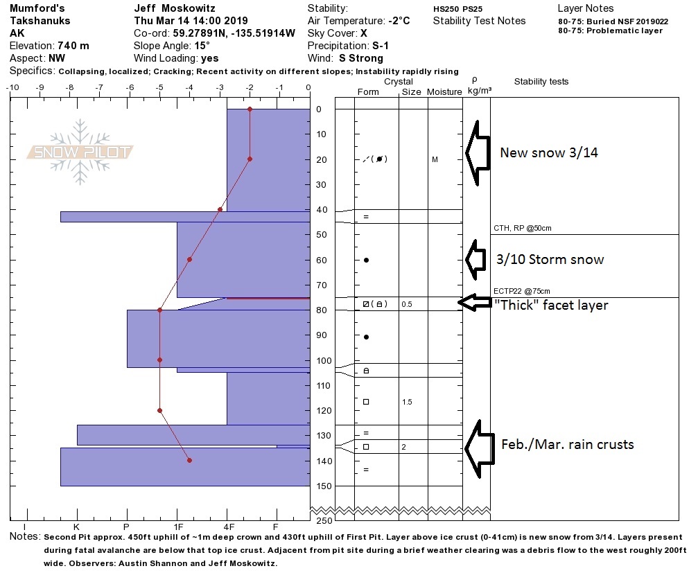 Looking objectively at the snowpack structure in the area, which was consistent, well-mapped, and widespread, the likely initial trigger was probably within the "Thick" facet layer. Based on the interview with the survivors, it seemed there was a smaller initial slide that was of less concern, and some moments later multiple step-downs happened, triggering wide and deep propagation. Still, the party was standing at the margin of clumps of small trees that may have acted as trigger points to deeper layers from the start. In most of the deepest areas, the slide appears to have stepped all the way down to the Nov. ice crust (it was described as rock hard "glare ice"). It was not feasible to measure exact depths, but the best estimates based on observations from multiple people on the scene place maximum crown depth near 3m in parts of the middle chute, 2m+ in the 3rd chute and bowl/cliffs just above the chutes, and closer to 80-100cm in the large upper bowl. Terrain: 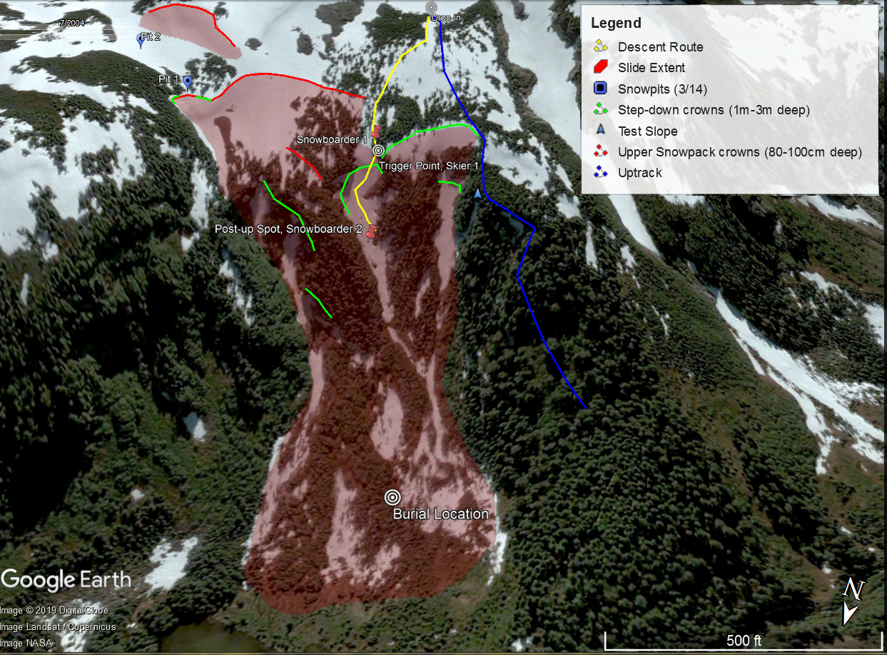
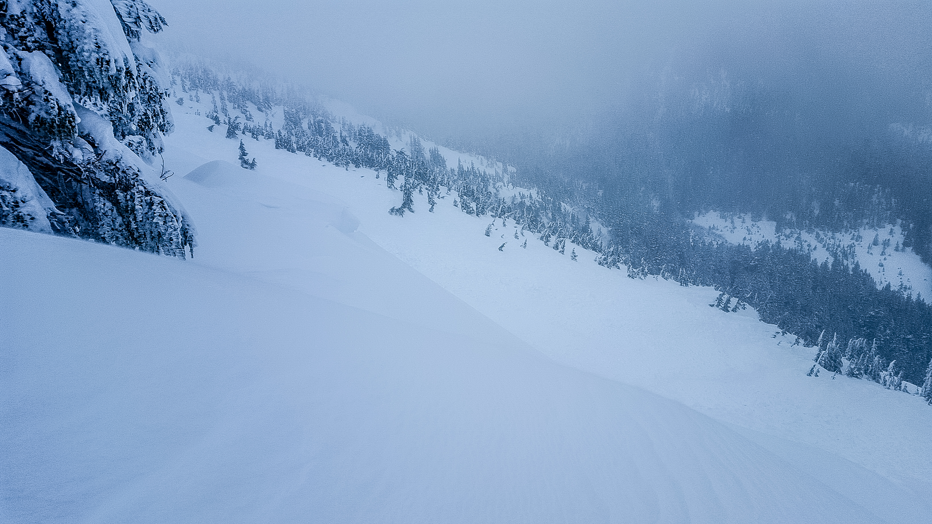
The terrain is extremely complex, with three primary chutes accessed from steep and exposed terrain above. Hazards are plentiful (though avoidable) and include cliffs, small sections of cornice, and many small trees. There is a primary terrain trap at the very bottom of the large runout where it meets the flats of the lake. And a few smaller gully terrain traps in the drainage of each chute.
Human / Rescue: Two splitboarders and one skier set out to ride in a very familiar area. Two of the three had been skiing this zone and specific terrain for over a decade. It was terrain they knew well. The plan for the day was not specific to any one line, they were simply seeking sheltered powder at/below treeline and had some ideas on where to find it. Snowboarder 1 had been riding in the area during the last storm, 3 days prior, and noted that the wind was blowing hard out of the south at the lake, with a slight rain crust on top of the new snow. On the day of the slide, Snowboarder 2 checked the nearby Mt. Ripinsky weather station on the HAC website. He noted the temperature trends vocally to Skier 1 and Snowboarder 1, but made no mention of whether he had looked at the last posted avalanche forecast. Neither of the two other riders had checked it. (The last posted forecast was valid Monday 3/11, and expired that same day). Posted danger was Considerable and problems were Storm Snow and Persistent Slab. Among other things, it stated:
Problem #1: Storm Snow Location: all aspects and elevations, but especially W-NW-N-NE aspects. Heavy snowfall rates yesterday combined with moderate-strong SE winds will have created quite a bit of wind loading on lee aspects. Fresh storm slabs will be 30-60+cm thick and resting on a thick bed of weak facetted snow. Bonding to the old snow will be poor, and there will be lots of settlement. Natural and human triggered avalanches are likely in any wind loaded or cross-loaded areas. Some slides could be large and step down to old persistent slabs 60-90cm deep, causing wide propagation. Avoid all avalanche terrain. Watch out in steep clearings in the trees where new snow piles up deep and consequences are high. Stay well away from terrain traps. This new danger will likely persist for a while, due to the thick nature of the persistent facets underneath the new snow. The group skinned up the valley a little, past the lake and chutes, to get a look at the valley and look for good riding for the day. They noticed some natural avalanches on north aspects up the valley that had run within the storm snow on steep, open, planar slopes well above treeline. The slides had likely run a few days before. Given this, they decided to avoid similar slopes, choosing lower-elevation terrain in the trees. They thought these areas would be protected from the winds and thus safer. They made a plan to go up a skin track they were familiar with, through the trees looker's-right of the Lake Chutes. From the top of the trees they would ski down towards Chute 2 (the middle chute), seeking to avoid wind-affected areas. There they could either ski the chute or duck into the trees to continue down, depending on conditions. Skier 1 said, "I don't think familiarity played a part. We approached just like any other day, with skepticism. We're always flexible on our plans." On the way up, they stomped on a small but steep test slope in the trees to help judge stability in the chutes. There was no result. They continued up to the drop-in point, assessing as they went, with quick hand pits. They did not see anything that gave cause for alarm. The three skied from the drop-in point to the entrance of Chute 2. From there, Skier 1 and Snowboarder 1 watched Snowboarder 2 ski the top of the chute and duck into a post-up spot in/near some trees mid-slope that they had always thought was a safe place to wait (they had skied this line together before, and had a protocol on where to wait in the trees). Skier 1 began to descend along the margin of the upper trees, and immediately triggered a slide within the new snow that was small at first. "It was triggered from a thin spot in the trees, where there were small trees under the snow." The two riders yelled "Avalanche!" down towards Snowboarder 2. At first the small slide seemed benign, and it seemed that Snowboarder 2 was safe. Then the avalanche stepped down, and began to propagate very wide and deep, taking the entire chute with it. Snowboarder 2 was quickly caught and swept down. The debris moved very fast. Skier 1 and Snowboarder 1 carefully descended the bed surface, which was described as very slick and hard, like glare-ice. It took approximately 4 minutes. They switched their beacons to receive close to the last-seen point, and were able to get a signal quickly as they descended the runout. Skier 1 quickly followed a curving flux line in, did a pinpoint search, and began probing. He hit Snowboarder 2 on the second probe strike. The two began shoveling, and got to Snowboarder 2's backpack first. They hastily dug around to his face, which was about 3ft deep total. He was unconscious. They checked for a pulse and positioned him for CPR. CPR was administered, but was ineffective due to trauma. Total burial time is estimated at about 8 minutes. He was wearing a helmet and did not have an airbag. The two were able to call 911 right from the site using a cell phone (the call came in at 12:44pm). Haines Search and Rescue immediately mobilized a helicopter from a private company, and it arrived in about an hour. Snowboarder 2's body was transported via helicopter. Skier 1 and Snowboarder 1 descended on their own via the trail they came up. Forecasters' Notes: - The rescuers (Skier 1 and Snowboarder 1) did an incredible job on the companion rescue and response. The recovery went about as fast as anyone can expect in this situation; they were well-equipped, practiced, and they did everything right. The official cause of death has not yet been released, but by all accounts it appears to be trauma. - Haines Search and Rescue and the helicopter pilot/company are also to be commended for an amazingly swift response. - Temperatures had been slowly warming up over the previous week, and the snowpack at this elevation was generally transitioning from cold and facetted winter conditions to warmer, moister, denser, spring conditions. - Skier 1 stressed the importance of the trees acting as trigger points to deeper layers. The snow was thinner around the small, mostly buried trees. We believe that step downs played a bigger role than trigger points for this avalanche, but it is certainly true that the trees on the slope were weak points in the hard slab that may have helped it fracture, and helped with the initial trigger as well. - In Haines, it is common for people to seek out steep terrain. The steeper the terrain, the more emphasis we place on "sluff management". If the initial smaller avalanche in this accident had not stepped down and triggered the entire chute, it is possible that some would have called it a "sluff" and written it off as inconsequential. We want to make sure people understand the seriousness of sluff (or any small avalanche). The dangers go beyond simply "managing" your sluff, in situations where a small slide can cause a large step-down avalanche (that is to say, in persistent-slab or deep-slab conditions). This commentary is less related to this particular accident, and more general to the approach many of us take in Haines. - In this accident and others before it, people were standing in "safe zones" that turned out to not be so safe. It cannot be stressed enough that we tend to overestimate the safety factor of trees in steep terrain. As riders we also tend to stop and rest or wait in places that feel safe, but are still actually quite exposed from above. If you are riding in terrain where the safe zones are still exposed from above (or even connected to the main slab), you should consider the possibility that there may not be any safe zones at all if a slab breaks wide and deep. - The deep, hard ice crust that acted as a bed surface was uniform across the entire zone, and this uniformity, combined with the uniform facet layer just above it is probably what allowed the slide to propagate so far. The layer was deep enough and old enough that most had forgotten it existed. You would have to dig quite deep to find it in most places.
- The March 10th snow/wind event was surprisingly strong. Winds during the frontal passage were near 60mph at 1000ft. 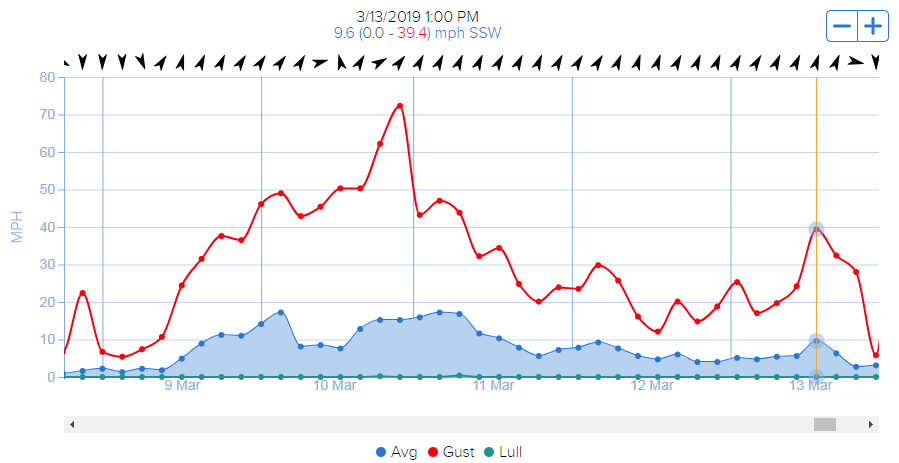
Our local winds are normally driven by pressure gradients through the fjord and tend to anchor to the terrain, but during this storm the strong frontal winds likely complicated our usual wind patterns, causing wind loading in unusual places. When we visited the site March 14th, the amount of wind loading was remarkable. 
- For Snowboarder 2, this was to be the last week of riding in Haines for the season. He was about to go to school in Juneau and wanted to get in some good riding before he left. This may have caused some pressure to push into bigger terrain. - Did climate change play a role in this accident? The two survivors believe it did. They had been riding in Haines for about 12 and 20 years, respectively. "The snowpack is just different now," They said. "It is warmer, thinner. Mid-winter rain events have become common. They create these crusts that just sit and wait all season." As forecasters, we tend to agree. Haines is in year 5 of what some would call a cycle of bad winters (and hopefully not a new normal). Temperatures have been warm, and the average winter snowline is roughly 1000ft higher than it used to be. The differences in the snowpack are obvious to anyone who remembers the old days of having consistent deep snowpack down to sea level. Rain crusts in the mountains used to be an exception, not a rule. Persistent Slab dangers were less common in our maritime areas. It could be argued that conditions are more dangerous now as a result of thinner snowpack, more frequent and thicker/harder crusts, and wild weather swings (long periods of cold and dry followed by pineapple-express-type storms). In the ski community, we are all hopeful to get back to the days of consistent winter snowfall and fewer mid-winter rain events. If that doesn't happen, we will have to adjust our ski habits, terrain choices, and mindset accordingly.
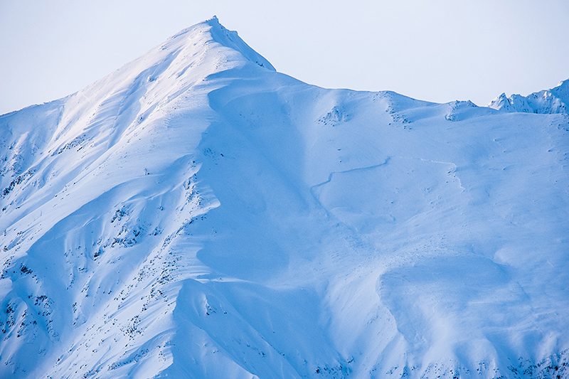
News: Additional Photos: 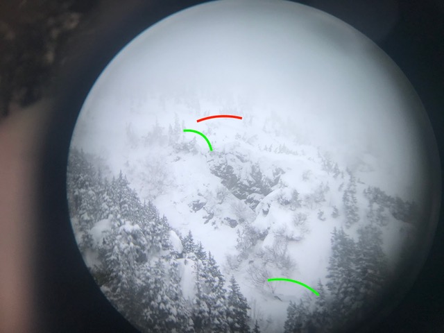 Image: Binocular view of some of the observed crown lines, corresponding to map above. Credit: Jonathon Cromwell.
|