Valdez
Above 3,000ftConsiderable
1,500 to 3,000ftConsiderable
Below 1,500ftConsiderable
Degrees of Avalanche Danger
Avalanche Problems
Problem 1
All three of our forecast zones have received significant snowfall in the last 48 hours. Storm totals of 18-36 inches have been recorded above 1000 feet with higher amounts expected in the upper mountains. Human triggered avalanches are likely up to 3 feet in depth. Conservative terrain choices will be essential for safe travel in avalanche terrain today.
New snow began with temperatures in the single digits and were deposited on a variable wind damaged crust. On 3/18 instabilities were observed within the lower half of the storm snow at a density change with small shooting cracks, easy hand shear results and easy results on ECT‘s all pointing to sensitive storm slabs that will be reactive to human triggers on slopes steeper than 30°. Human triggered avalanches will be likely today on slopes steeper than 30° especially where the surface has been stiffened by wind. Convex and wind loaded terrain will be the most sensitive.

Likelihood:
- Almost Certain
- Very Likely
- Likely
- Possible
- Unlikely
Size:
- Historic
- Very Large
- Large
- Small
Trend
- Increasing
- Steady
- Decreasing
Problem 2
Over three weeks of dry and windy weather previous to this storm has decreased the height of our snowpack and caused layers near the ground to facet (loose strength).
Todays storm is adding stress to weak snow at the bottom of our snowpack. It is currently unlikely for human triggered or natural avalanches to occur at this layer. This is due to the strength of old wind affected snow at this interface, and an insufficient amount of new snow to tip the scales. Depth hoar may become a concern later in the season if our area starts to receive more consistent snowfall and the very strong wind damaged at the new/old interface starts to break down and loose strength within the snowpack. As very hard wind slabs break down within the snowpack a person or machines weight will have a more direct affect on weak layers at the bottom of the snowpack.

Likelihood:
- Almost Certain
- Very Likely
- Likely
- Possible
- Unlikely
Size:
- Historic
- Very Large
- Large
- Small
Trend
- Increasing
- Steady
- Decreasing
Avalanche Activity
Below is a summary of observed Avalanche activity from the last 7 days. Avalanches that were noted earlier in the season can be viewed by clicking the link below.
If you trigger or observe an avalanche consider leaving a public observation.
No natural or human triggered avalanches have been reported or observed the last 7 days. Last activity observed occurred on the 7th and 8th during a strong temperature inversion that brought above freezing temperatures to mid and upper elevations for an extended period. Strong north winds on 3/9-10 may have produced some small avalanches, although none have been reported or observed.
Weather
Check out our updated weather tab! A collection of local weather stations are available for viewing with graphs and tabular data included.
NWS Watches, warnings and advisories
NONE
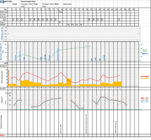
NWS Point forecast for Thompson Pass
Date               Sunday 03/19/23         Monday 03/20/23
Time (LT)          06    12    18    00    06    12    18    00    06
Cloud Cover        OV    SC    SC    BK    SC    FW    BK    OV    OV
Cloud Cover (%)    95    40    45    60    40    20    55    80    95
Temperature        21    22    24    14    10    18    22    15    15
Max/Min Temp                   26           9          24          14
Wind Dir           SE    SE     E    NE    NE     E     S     S    SE
Wind (mph)          9     5     2     9     6     4     9    11    13
Wind Gust (mph)
Precip Prob (%)    70    20    10    10    10    10    30    40    50
Precip Type         S     S                       S     S     S     S
12 Hour QPF                  0.03        0.00        0.02        0.05
12 Hour Snow                  0.1         0.0         0.0         0.0
Snow Level (kft)  0.0   0.0   0.0   0.0   0.0   0.0   0.0   0.0   0.0
Click on link below for Thompson Pass weather history graph:
| Date:
03/19 |
24 hr snow | HN24W* | High temp | Low temp | 72 hour SWE* | March snowfall | Seasonal snowfall | Snowpack Depth |
| Valdez | Trace | .22 | 37 | 27 | 1 | 13 | 231 | 53 |
| Thompson Pass | 12 | N/O | 29 | 20 | N/O | 15 | 408 | 40 |
| 46 mile | 4 | N/O | 33 | 12 | N/O | 26 | ~108** | 58 |
*HN24W- 24 hour Snow water equivalent in inches
*SWE– Snow water equivalent
**46 mile seasonal snowfall total begins December 1st.
Additional Information
Click on the link below for a running summary of the seasons weather history.
Announcements
The avalanche hazard is Considerable at all elevations. 18-36 inches of new snow has accumulated at low elevations with higher amounts and moderate to strong winds at upper elevation. This new snow will need time to settle and bond to the underlying snowpack. In the meantime, human triggered avalanches are likely up to 3 feet in depth and natural avalanches are possible.
Posted by Gareth Brown 03/19 9:00 am.
For a description of current avalanche problems, weather information, season history and more click the (+ full forecast) button. Avalanche forecasts will be issued Wednesday-Sunday.
If you have pictures of recent natural or human triggered avalanches or notice signs of instability such as shooting cracks or collapsing, leave an observation to help improve forecast accuracy.