Valdez
Above 3,000ftModerate
1,500 to 3,000ftModerate
Below 1,500ftModerate
Degrees of Avalanche Danger
Avalanche Problems
Problem 1
Moderate snowfall today is forecasted to deliver 4-8 inches of new snow. If this storm delivers the upper end of forecasted amounts or more, shallow storm slabs will be initially sensitive to human triggers. Intense snowfall rates of more than 1 inch per hour should be a warning sign that the upper snowpack is being overloaded. Shooting cracks are a sign of instability and steep convex terrain will be the first to become reactive.

Likelihood:
- Almost Certain
- Very Likely
- Likely
- Possible
- Unlikely
Size:
- Historic
- Very Large
- Large
- Small
Trend
- Increasing
- Steady
- Decreasing
Problem 2
Triggering an old wind slab on lee aspects (SE-NW) will remain a concern for today. On 1/7 winds increased to moderate in wind channeled areas including Thomson Pass. A significant amount of loose snow was available for transport, building slabs in specific locations that may remain reactive in isolated locations. A few inches of new snow today will be adding stress to these wind slabs. Watch for signs of instability such as shooting cracks, collapsing and recent avalanche activity.
Old wind slabs are not expected to remain reactive in most locations due to a lack of a persistent grain (facets) existing below wind affected snow.
In many locations where the snow is unaffected by wind the hazard is lower.

Likelihood:
- Almost Certain
- Very Likely
- Likely
- Possible
- Unlikely
Size:
- Historic
- Very Large
- Large
- Small
Trend
- Increasing
- Steady
- Decreasing
Problem 3
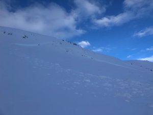
For the first time since 12-16 a natural avalanche was reported that failed at faceted snow near the base of our snowpack. This occurred on a SW aspect ~3500′ between Catchers Mitt and Loveland Basin, crown 1-6 feet in depth. This is a repeat offender slope when loaded by wind, although is noteworthy due to its depth.
This avalanche has thus far been an outlier, however indicates that the strong wind affected snow that has capped the early season facets may be losing strength (faceting) making weak snow more easily affected by a person or Snowmachine at the surface in certain areas.
Recently our snowpack has been slowly building with light snowfall and calm to moderate winds. This weather will help our snowpack to heal in the longterm but in the short term will be putting incremental stress on weak layers at the base of our snowpack. This is a fine balance and is very difficult to assess as spatial (place to place) variability is currently significant. This recent avalanche is a perfect example that persistent weak layers are difficult to predict/assess and conditions may be different depending upon the area you choose to travel.
In most places at this point, triggering a deep hard slab avalanche is very unlikely, but the consequences would be significant. Keep this in mind when choosing terrain and strive to practice safe protocols. These include: good communication, skiing one at a time and avoiding terrain traps.

Likelihood:
- Almost Certain
- Very Likely
- Likely
- Possible
- Unlikely
Size:
- Historic
- Very Large
- Large
- Small
Trend
- Increasing
- Steady
- Decreasing
Avalanche Activity
Below is a summary of observed Avalanche activity from the last 7 days. Avalanches that were noted earlier in the season can be viewed by clicking the link below.
If you trigger or observe a natural avalanche consider leaving a public observation.
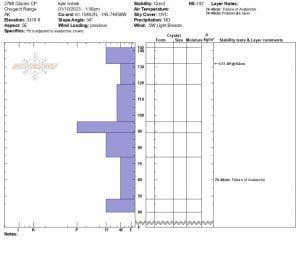
1/7- Deep hard slab avalanche release between Catchers Mitt and Loveland Basin, ~3500’/SW aspect/ crown depth 1-6 feet. HS-N-R2-D2.
Crown Profile:
Weather
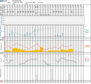
Check out our updated weather tab! A collection of local weather stations are available for viewing with graphs and tabular data included.
NWS Watches and warnings
NONE
NWS Point forecast for Thompson Pass
Date               Wednesday 01/11/23      Thursday 01/12/23
Time (LT)          06    12    18    00    06    12    18    00    06
Cloud Cover        OV    OV    BK    OV    OV    OV    OV    OV    OV
Cloud Cover (%)   100   100    60    70    90    70    80    90    90
Temperature        15    18    18    16    18    19    18    14    15
Max/Min Temp                   19          15          21          14
Wind Dir            E     E     E     E    NE     E    NE    NE    NE
Wind (mph)         10     6     3     4     6     6     9     6     5
Wind Gust (mph)                                                    34
Precip Prob (%)    90    80    10    20    30    20    10    20    10
Precip Type         S     S           S     S     S           S
12 Hour QPF                  0.24        0.02        0.03        0.02
12 Hour Snow                  3.8         0.0         0.0         0.0
Snow Level (kft)  0.7   1.0   0.9   0.8   0.9   0.6   0.5   0.3   0.1
Click on link below for Thompson Pass weather history graph:
| Date:
01/11 |
24 hr snow | HN24W* | High temp | Low temp | 72 hour SWE* | January snowfall | Seasonal snowfall | Snowpack Depth |
| Valdez | 4 | .25 | 31 | 24 | .5 | 14 | 111 | 43 |
| Thompson pass | 1 | .1 | 27 | 12 | N/O | 33 | 227 | 43 |
| 46 mile | Trace | – | 5 | -11 | 0 | 20 | ~56** | 38 |
*HN24W- 24 hour Snow water equivalent in inches
*SWE– Snow water equivalent
**46 mile seasonal snowfall total begins December 1st.
Additional Information
Click on the link below for a running summary of the seasons weather history.
Announcements
The avalanche hazard is moderate. Shallow storm slab avalanches may be reactive to triggers if more snow arrives than forecasted. Human triggered wind slab avalanches will be possible 1-2 feet deep in isolated locations. These include lee slopes and cross loaded terrain near Thompson Pass or other wind channeled terrain.
Posted by Gareth Brown 01/11 8:00 am.
For a description of current avalanche problems, weather information, season history and more click the (+ full forecast) button. Avalanche forecasts will be issued Wednesday-Sunday.