Haines Avalanche Center
Above 2,500ftModerate
1,500 to 2,500ftModerate
Below 1,500ftLow
Degrees of Avalanche Danger
Avalanche Problems
Problem 1
The Bottom Line: We are starting our season with an Assessment mindset. So far this autumn has been marked by extremes — both warm and cold, snowy and rainy. This is a much different set up than we had last season at this time. Overall you can find lots of variability due to multiple strong wind events (most recently from the SE, increasing today from the NW), with thin areas having a weak facetted snowpack and thicker areas containing midpack rain crusts. The main threat for now is increasingly stiff wind slabs due to NW winds picking up Saturday into Sunday. Any freshly wind loaded areas may harbor wind slabs 1-2ft thick which could be triggered by a human.
Wind loaded slopes and cross-loaded gullies should be avoided or carefully managed. Minimize your exposure to these slopes, and always travel one-at-a-time through any suspect areas. Rocks will be a major safety hazard as well, so take it slow and easy, and keep your avalanche eyeballs on, especially in wind loaded areas and convexities!
Additional Considerations:
The cold snap in early November created basal facets in thin areas above 1000ft. These facets haven’t been active yet, but the possibility still exists that an avalanche could fail at the ground in thin areas with a new slab on top. This concern may grow into a deep slab problem over time if these facets weaken into depth hoar.

Likelihood:
- Almost Certain
- Very Likely
- Likely
- Possible
- Unlikely
Size:
- Historic
- Very Large
- Large
- Small
Trend
- Increasing
- Steady
- Decreasing
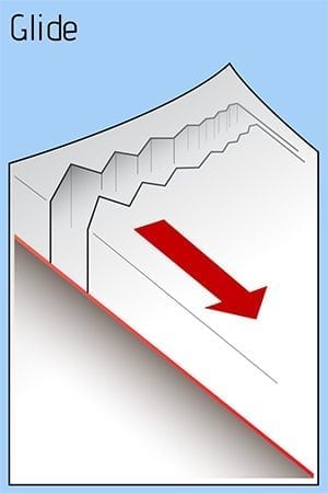
Problem 2
To add to our early season uncertainties, there was a significant glide avalanche cycle Nov 16-18 during a strong warming event at upper elevations. These slides mainly occurred in areas near treeline on NE aspects, where the snowpack is fat and sitting on steep grassy slopes underneath. There are still many glide cracks that have not yet failed into full avalanches. Despite the cooling weather, these cracks still need to be avoided as they may still fail at any time. Keep an eye above you and stay out from underneath these cracks.
Likelihood:
- Almost Certain
- Very Likely
- Likely
- Possible
- Unlikely
Size:
- Historic
- Very Large
- Large
- Small
Trend
- Increasing
- Steady
- Decreasing
Avalanche Activity
Glide avalanches from 11/18, transitional zone, 2500ft


| DATE | LOCATION | SIZE | TRIGGER | DETAILS | START ZONE | TYPE | BED SFC |
|---|---|---|---|---|---|---|---|
|
Nov 18, 2022
(+/- 1 day)
|
Takhin Ridge | D2-3 R2-3 | N-Natural | multiple Glide Avys- N,NE aspects | N – NE | Glide | Ground |
|
Nov 18, 2022
(+/- 1 day)
|
Transitional Zone glacier headwalls | D3 R4 | N-Natural | two different surface wind slab releses. wide propagation | NE
5250ft
|
Wind Slab | Old snow ~30cm deep |
|
Nov 18, 2022
(+/- 1 day)
|
Transitional Zone | D2.5 | N-Natural | Wet loose sluffs that entrained large amount of debris and gouged to ground | N | WL-Wet Loose | Ground |
Weather
Forecast:
Friday looks mostly calm and cloudy as Thursday’s storm moves out, and a new one slides past us Friday night with 2-5″ of accumulation. Saturday – Sunday will bring clearing skies, and increasing arctic outflow with NW winds becoming strong and temperatures dropping substantially.
Seasonal Summary:
- Nov 20-25 brought about 2ft of new snow above 2000ft (about 1ft in the Pass zone)
- Mid November was very warm, with temperatures reaching over 40F at 5000ft
- Cold weather set in Nov 4th – 9th, with alpine temps down to 8F at times
- A NW wind event Nov. 6th blew away much of snow in exposed areas
- 2 to 3ft of snow fell in Early November down to sea level
- October 26-27th brought in 5-12″ of heavy wet snow above 1500ft
- The first layer of snow to remain into winter fell above 3,500ft on Oct 21st. It was 6-12″ deep.
| Snow Depth [in] | Last 24-hr Snow/SWE [in] | Last 3-days Snow/SWE [in] | Today’s Freezing Level [ft] | Today’s Winds | Next 24-hr Snow/SWE | |
| Mount Ripinsky @ 2,500′ | 49″ | 0″ / 0.00″* | 17″ / 1.60″* | 0′ | mod, NW | 0″ / 0.00″* |
| Flower Mountain @ 2,500′ | 34″ | 0″ / 0.00″ | 18″ / 1.60″ | 0′ | mod, NW | 0″ / 0.00″* |
| Chilkat Pass @ 3,100ft | 10″ | 0″ / 0.00” | 11″ / 0.95” | 0′ | mod, NW | 0″ / 0.00″* |
( *star means meteorological estimate )
Additional Information
It’s time to start thinking avalanche. Dust off your gear and make sure it is fully functional. Put new batteries in your beacons! Do a beacon practice to start the season and keep your skills fresh.
If you head into the hills, watch out for avalanche prone areas, and be especially careful of rocks and hidden hazards like crevasses beneath the snow. WEAR A HELMET!
Announcements
We have begun regular forecasting for this winter (Fridays-Sundays). Click the Full Forecast link below to read more. Please submit your observations if you head out into the hills!