Haines Avalanche Center
Above 2,500ftConsiderable
1,500 to 2,500ftConsiderable
Below 1,500ftModerate
Degrees of Avalanche Danger
Avalanche Problems
Problem 1
Aspect: All
Elevation: Near and Above Treeline
Bottom Line: A slow moving low hovers over the area and continues to drop wet snow. This active weather pattern that started 3/11 has brought ~ 1.5″ of water. The new snow is a sandwich of moist snow top and bottom, with a thin layer of drier snow in the middle from 3/14 when temps dropped significantly (low 7F @ ~4000′). This sandwich is sitting on a variety of smooth and rough surfaces from a wind event prior. Causing possible natural and likely human triggered avalanches. Careful snowpack evaluation and conservative decision making is essential.
Travel Advice:
- Use cautious route finding.
- Pay attention to red flags: shooting cracks and collapse.
- Use small and safe test slopes for feedback.
- Keep wide margins on slopes < 30 degree slope angle and complex terrain.
- Ask yourself. If this snow moves, where is it going to stuff me. Terrain trap and what kind?
- Be patient. This problem will heal in time.
Additional Consideration:
- We believe deeper persistent layers are currently dormant. However, you could still trigger a persistent slab in thin or shallow snow even if we haven’t had recent feedback or avalanche activity.
- With the beginning of March comes a higher sun angle than we have seen for the last couple months. Surface warming will begin to be prevalent on solar days, especially around exposed rocks and creating thin and/or weak spots where you could trigger these deeper layers.
- A variety of wind loading patterns throughout the season have created sizeable cornices on all aspects near mountain tops and ridgelines. Beware that cornices can break much further back than expect, can trigger deeper persistent weak layers and are sensitive to warming, temperature changes and direct sunlight.
- Remember that persistent slabs are unpredictable and that tests and observations can be unreliable. A probe can be very helpful to determine snow depth and presence of deeper buried weak layers by noting resistance as the probe moves through the snow.
- Continue to utilize safe travel protocol, wide margins of safety, and collect more information when it comes to entering committing terrain.

Likelihood:
- Almost Certain
- Very Likely
- Likely
- Possible
- Unlikely
Size:
- Historic
- Very Large
- Large
- Small
Trend
- Increasing
- Steady
- Decreasing
Problem 2
Aspect: All
Elevation: Tree Line and above
Bottom Line: Keep in mind that with new snowfall, any existing wind slabs from the last few days may be difficult to near impossible to identify. A switching pattern of south and north winds has this problem on all aspects. A variety of light to strong winds associated with new moderate amounts of snow could have reactive wind slabs 1-4′ deep. These winds also could be sitting on a variety of smooth and rough surfaces. Moderate to strong south winds today will keep this problem reactive. Naturally triggered avalanches are possible and human triggered avalanches are likely. Careful snowpack evaluation and conservative decision making is essential.
Travel Advice:
- Look for blowing or drifting snow or rapid loading.
- Avoid slopes with textured surfaces, suspect loading, or pockets of wind slab.
- Identify and avoid shallow areas including trigger points around rocks, cliffs, and trees.
- Understand wind slabs can break in shallow spots and propagate deeper.
- Look, listen and feel for shooting cracks, collapses and hollow sounds.
- Avoid terrain trap areas such as cliffs and gullies, and areas where it is hard to escape off to the side.

Likelihood:
- Almost Certain
- Very Likely
- Likely
- Possible
- Unlikely
Size:
- Historic
- Very Large
- Large
- Small
Trend
- Increasing
- Steady
- Decreasing
Avalanche Activity
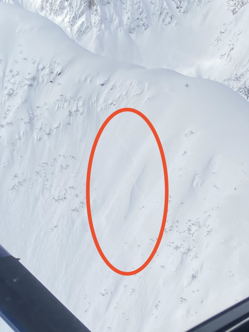
3/5-7/2022 – Numerous D1-D2 natural and human triggered activity 2-12″+ deep were reported on multiple aspects above treeline.
From 3/3, Wind slab on SE aspect at 2500ft, numerous reports of natural and human triggered wind slabs on multiple aspects above treeline 5-30cm deep from 3/3 – 3/9 as the wind direction switched direction from south to north.
From 1/29 to 2/1, several reports came in of recent avalanches in the alpine. The common characteristics of these slides were wide propagation, and failing 2-5ft deep at the interface below the wind slabs from last week’s atmospheric river. We have strong reason to suspect these slides occurred on a buried surface hoar layer from 1/20. They happened on all aspects, at elevations from 3000 – 5000ft, and all were in wind sheltered areas below ridges, features, and starting zones. Slide were observed in the Transitional and Lutak zones.
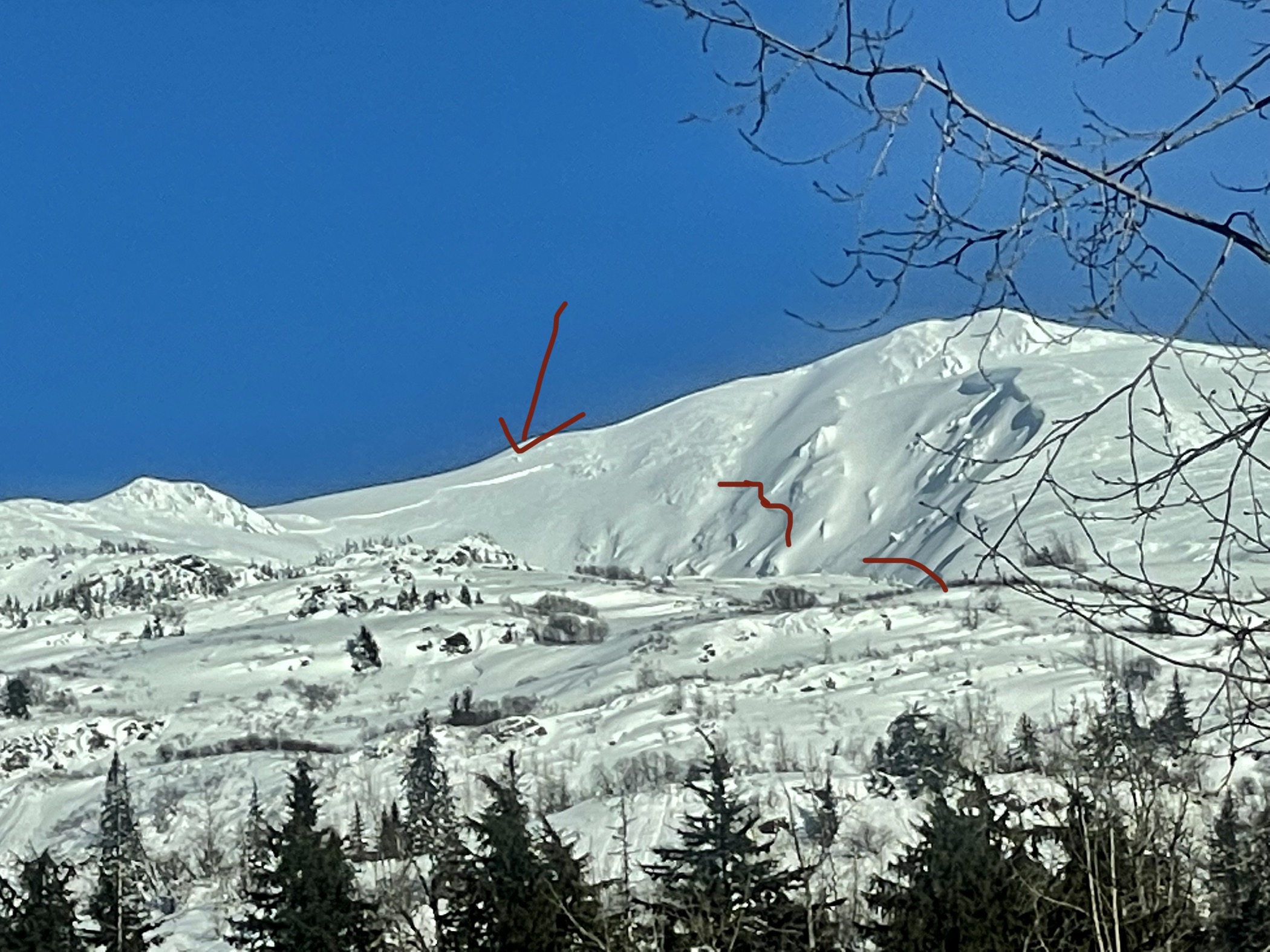
4Winds zone. SW. 4000-5000′

Near Mt. Kraus
The confluence of the Boundary and Saksaia glaciers above Glacier Creek. N. ~4700′
Weather
Forecast:
Lingering rain and snow showers continue throughout the day with minor accumulation possible. Above 1,000′, 2-4” of expected snow. Moderate southeast winds gusting to strong. Freezing levels up to 700′. High temperatures in the low 30s. Slight breaks in precipitation bands could open up the sky and create colder temperatures.
Seasonal Summary:
- March 1th-17th precipitation totals of 1-1.5″ SWE snow levels up to 2,000′ with south to north winds
- March 3rd-7th reverse loading event with south winds, then north winds, continued diurnal temps.
- Feb 28th-March 4th saw diurnal temperature swings followed by light accumulations of 2-4″.
- Feb 16-19th light snow 3-4″ with freezing levels reaching 1,500′ with strong south winds.
- Feb 12-14th had freeze/thaw cycles that locked up the snowpack to ~4,000′.
- Feb 5th-9th brought snow levels near 3,500ft, and 2.5-4″ of SWE with strong south winds.
- Feb 1st-4th brought in 12-24″ of low density powder.
- Jan 27-29 brought 1.5 – 2.4″ of SWE with freezing levels near 1500ft.
- An Atmospheric river hit Jan 21-22. It brought in 2-7″ of SWE (2-5ft of snow above 2500ft, mostly rain below)
- Jan 9th-15th brought 24-48″ of new snow in the alpine, with some light rain up to 3,500ft, followed by heavier rain up to 2000ft.
- Very strong NW winds and arctic temperatures blasted the area the first week of January.
- Jan 1st: New snow (20″ in Lutak, 7″ Transitional zone) buried any preserved surface hoar.
- Moderate NW winds hit exposed slopes Dec 19-20th.
- Surface hoar formed on all aspects and elevations Dec 17-18th.
- December brought in about 2-5 feet of snowfall (highest in Lutak zone), and a few strong NW wind events.
- November brought consistent heavy snowfalls, cold weather, and SE winds.
- October brought heavy snow in the alpine, followed by a few rain/sun crusts.
| Snow Depth [in] | Last 24-hr Snow/SWE [in] | Last 3-days Snow/SWE [in] | Today’s Freezing Level [ft] | Today’s Winds | Next 24-hr Snow/SWE | |
| Mount Ripinsky @ treeline ** | 140″* | 5″ / 0.5″* | 17” / 1.7″* | 700′ | Strong, SE | 3″ / 0.3”* |
| Flower Mountain @ treeline | 83″ | 4″ /0.4″ | 11″ / 1.2″ | 700′ | Strong, SE | 3″ / 0.3″ |
| Chilkat Pass @ 3,100ft | 40″ | 2.0” / 0.2” | 3” / 0.3” | 0′ | Moderate, SE | 2″ / 0.2” |
( *star means meteorological estimate )
** The Ripinsky weather station is in need of repair, and will likely be down until Summer. Make a donation to the Haines Avalanche Center for next season here.
Additional Information
Safe backcountry travel requires training and experience. You control your own risk by choosing where, when and how you travel. Ride rescue ready. Be prepared for an emergency. Prevent hypothermia. Carry bear spray. Winter is a high consequence environment.
Become a sustaining Haines Avalanche Center Member by clicking the poster or visiting alaskasnow.org/joinHAC. Support local forecasts, observations, education and weather stations. Join a community of winter recreationalists. Benefit from collective knowledge and skills. Help keep your friends and family safe in the backcountry. Get a free limited edition mountain buff, or neck gaiter with a $50 membership (first 20 members!).
Practice like you play. Make sure all your rescue gear is fully functional and your beacon has NEW batteries. Make sure 1) everyone in the group has a functioning beacon, shovel and probe 2) knows how to use them and 3) has trained in companion rescue in the last year. Keep your skills fresh. If you head into the hills, watch out for red flag avalanche conditions, natural avalanches, whoomphing or collapsing, and shooting cracks.
Education Video Links:
- AIARE
- How to Practice Avalanche Rescue Snowmobile Edition: https://youtu.be/2ML499MMDfM
- AK Sled Shed Motorized Learning:
- Intro: https://youtu.be/aoagKHfGkxs
- Personal Electronics in Avalanche Terrain: https://youtu.be/2Vz9S0OEyFk
- Snowmobile Macgyver Tool Kit: https://youtu.be/4WBNu_t6Bbk
- Head and Face Protection: https://youtu.be/jIzW89wOyZI
- Pre-season prep: https://youtu.be/zJmrb8cZlR4
- My Transceiver: https://youtu.be/yblaDWP7Jf8
- BCA Avalanche Safety for Snowmobilers
- How to Fix Common Snowmobile Problems in the Field: https://youtu.be/g9fiTxEvuFk
- Sleducation: Avalanche Safety for Snowmobilers: https://youtu.be/EWFOd_9DYb8
- Intro to Avalanche Transceivers for Snowmobilers: https://youtu.be/6ZLSBmsceog
- Avalanche Transceiver Trailhead Test for Snowmobilers: https://youtu.be/rWoXbadFBsY
- Avalanche Transceiver Searching Use Snowmobiles: https://youtu.be/w1ucyI6LMXM
- BCA Avalanche Rescue Series
- Beacon Search 101: https://youtu.be/nnHXLVA2FcE
- Avalanche Probing 101: https://youtu.be/-0_yDN5Drzw
- Avalanche Shoveling 101: https://youtu.be/dGQg9o3vAkM
- Organizing a Backcountry Rescue: https://youtu.be/gywtmukgt8s
- Post Avalanche Patient Care: https://youtu.be/9FyIeUy4wpQ
- Backcountry Evacuation: https://youtu.be/WPF-dciefL8
- Complex Multiple Burials Backup Techniques: https://youtu.be/pB6AfY2KyYo
- National Avalanche Center
- Avalanche Problems Explained: https://youtu.be/DkbnT_9-cHU
- Intro to North American Avalanche Danger Scale: https://youtu.be/r_-KpOu7tbA
Announcements
Early to mid-March has historically claimed the most lives to avalanches in our mountains. Spring time is exciting, but remember to keep your stoke in check and in line with the weather and avalanche conditions. Click the +Full Forecast button below to read the details. Please submit your observations if you head out!