Haines Avalanche Center
Above 2,500ftConsiderable
1,500 to 2,500ftConsiderable
Below 1,500ftConsiderable
Degrees of Avalanche Danger
Avalanche Problems
Problem 1
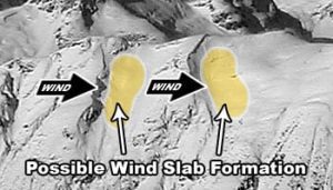
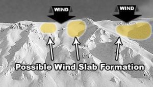
Aspect: N-NW-W aspects with SE winds
Elevation: Tree-line and above.
Bottom Line:
Sustained Light to Moderate SE winds will continue to form Winds Slabs on lee aspects. This problem will be widespread in exposed areas and specific to terrain features in more sheltered areas. Careful snowpack evaluation, cautious route finding and conservative decision making are essential. Human-triggered avalanches are likely and natural ones are possible 1-3′ deep.
Travel Advice:
- Avoid wind loaded aspects!
- Look for blowing snow, shooting cracks, whumphing or collapsing that indicate a stiffer slab over weaker snow.
- Wind slabs can break above you and are most reactive during formation.
- Use other visual clues such as scoring, wind textured snow, or phat loaded pillows to identify locations of the problem.

Likelihood:
- Almost Certain
- Very Likely
- Likely
- Possible
- Unlikely
Size:
- Historic
- Very Large
- Large
- Small
Trend
- Increasing
- Steady
- Decreasing
Problem 2
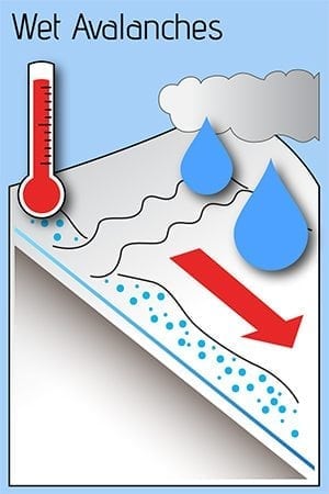
Aspect: All aspects
Elevation: Below freezing levels ~1500′
Bottom Line:
Freezing levels are somewhere around ~1,500ft and rain on snow below this elevation continues to severely weaken snow at the surface. At these lower elevations the snowpack is fully saturated and weak. Human triggered wet sluffs and slabs are likely today in steep terrain.
Travel Advice:
- Have you ever been caught in a wet sluff? Even small wet sluffs can be very heavy, and drag you down into a tree, a terrain trap, or over a cliff.
- Avoid slopes steeper than 30 degrees, especially if you find saturated snow more than ankle-deep.
- Stay out of gullies and other terrain traps, where wet slides and debris can come down from above and bury a person.
Likelihood:
- Almost Certain
- Very Likely
- Likely
- Possible
- Unlikely
Size:
- Historic
- Very Large
- Large
- Small
Trend
- Increasing
- Steady
- Decreasing
Problem 3
Aspect: W-N-E
Elevation: Tree-line and above.
Bottom Line: Surface hoar was observed 1/20 widespread to specific areas in this zone. New snow and fresh Wind Slabs lay on top this weak layer. Careful snowpack evaluation, cautious route finding and conservative decision making are essential. Human-triggered avalanches are likely and natural ones are possible 1-4′ deep.
Travel Advice:
- Look for recent natural avalanches.
- Watch for red flags: shooting cracks and collapsing (whumphing).
- Give wide travel margin to suspects slopes, one at time, eyes on!
- Avoid terrain with traps and complexity.
- Use travel test pits to identify suspect layer.
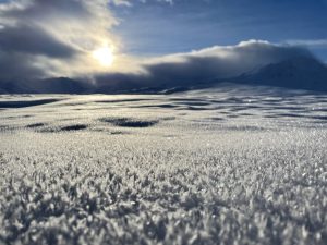
Surface Hoar from Flower Mountain on 1/20/2022

Likelihood:
- Almost Certain
- Very Likely
- Likely
- Possible
- Unlikely
Size:
- Historic
- Very Large
- Large
- Small
Trend
- Increasing
- Steady
- Decreasing
Avalanche Activity
01/15/2022 – An observation from Four Winds Mountain reported a collapse and a remote trigger of an approximately 200′ wide avalanche at 3,000′ on a northern aspect. It was estimated to run a couple hundred feet but low visibility kept observations to a minimum
01/17/2022 – On solar aspects past Mosquito Lake and above Lutak Inlet small point releases were reported above treeline on steep alpine features.
01/22/2022 – A D3 wet slab avalanche was reported in the Chilkat Inlet with a starting zone around 2,000′ that entrained dirt and mud near Witches Tit. Numerous D2 storm snow slides were observed near Pyramid Harbor.
Weather
Forecast:
Overnight light to moderate rain will continue into Saturday and then begin to diminish by end of day. Rain total around 1″. Lower rainfall amounts than expected from storm due to rain shadow area of Haines and Haines Hwy. Temps will be similar to yesterday, with Freezing Levels around 1500′. Continued light to moderate SE winds.
Seasonal Summary:
- An Atmospheric river hit Jan 21-22. It brought in 2-7″ of SWE (2-5ft of snow above 2500ft, mostly rain below)
- Jan 9th-15th brought 24-48″ of new snow in the alpine, with some light rain up to 3,500ft, followed by heavier rain up to 2000ft.
- Very strong NW winds and arctic temperatures blasted the area the first week of January
- Jan 1st: New snow (20″ in Lutak, 7″ Transitional zone) buried any preserved surface hoar.
- Moderate NW winds hit exposed slopes Dec 19-20th
- Surface hoar formed on all aspects and elevations Dec 17-18th
- December brought in about 2-5 feet of snowfall (highest in Lutak zone), and a few strong NW wind events
- November brought consistent heavy snowfalls, cold weather, and SE winds
- October brought heavy snow in the alpine, followed by a few rain/sun crusts
| Snow Depth [in] | Last 24-hr Snow/SWE [in] | Last 3-days Snow/SWE [in] | Today’s Freezing Level [ft] | Today’s Winds | Next 24-hr Snow/SWE | |
| Mount Ripinsky @ treeline ** | 76″ | 5″ / 0.40 * | 3″ / 2.00* | 1500′ | mod, SE | 2″ / 0.90* |
| Flower Mountain @ treeline | 76″ | 6″ /0.60″ | 12″ /1.2″ | 1500′ | mod, SE | 9″ / 1.00 “ |
| Chilkat Pass @ 3,100ft | 25″ | 2″ / 0.10 | 4″ /0.25″ | 1500′ | mod, SE | 6″ / 0.75 * |
( *star means meteorological estimate )
** The Ripinsky weather station is in need of repair, and will likely be down until Summer.
Additional Information
Safe backcountry travel requires training and experience. You control your own risk by choosing where, when and how you travel. Ride rescue ready. Be prepared for an emergency. Prevent hypothermia. Carry bear spray. Winter is a high consequence environment.
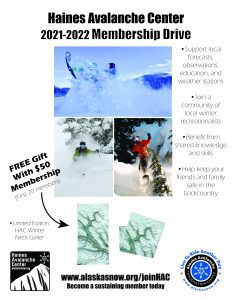
Become a sustaining Haines Avalanche Center Member by clicking the poster or visiting alaskasnow.org/joinHAC. Support local forecasts, observations, education and weather stations. Join a community of winter recreationalists. Benefit from collective knowledge and skills. Help keep your friends and family safe in the backcountry. Get a free limited edition mountain buff, or neck gaiter with a $50 membership (first 20 members!).
Practice like you play. Make sure all your rescue gear is fully functional and your beacon has NEW batteries. Make sure 1) everyone in the group has a functioning beacon, shovel and probe 2) knows how to use them and 3) has trained in companion rescue in the last year. Keep your skills fresh. If you head into the hills, watch out for red flag avalanche conditions, natural avalanches, whoomphing or collapsing, and shooting cracks.
Education Video Links:
- AIARE
- How to Practice Avalanche Rescue Snowmobile Edition: https://youtu.be/2ML499MMDfM
- AK Sled Shed Motorized Learning:
- Intro: https://youtu.be/aoagKHfGkxs
- Personal Electronics in Avalanche Terrain: https://youtu.be/2Vz9S0OEyFk
- Snowmobile Macgyver Tool Kit: https://youtu.be/4WBNu_t6Bbk
- Head and Face Protection: https://youtu.be/jIzW89wOyZI
- Pre-season prep: https://youtu.be/zJmrb8cZlR4
- My Transceiver: https://youtu.be/yblaDWP7Jf8
- BCA Avalanche Safety for Snowmobilers
- How to Fix Common Snowmobile Problems in the Field: https://youtu.be/g9fiTxEvuFk
- Sleducation: Avalanche Safety for Snowmobilers: https://youtu.be/EWFOd_9DYb8
- Intro to Avalanche Transceivers for Snowmobilers: https://youtu.be/6ZLSBmsceog
- Avalanche Transceiver Trailhead Test for Snowmobilers: https://youtu.be/rWoXbadFBsY
- Avalanche Transceiver Searching Use Snowmobiles: https://youtu.be/w1ucyI6LMXM
- BCA Avalanche Rescue Series
- Beacon Search 101: https://youtu.be/nnHXLVA2FcE
- Avalanche Probing 101: https://youtu.be/-0_yDN5Drzw
- Avalanche Shoveling 101: https://youtu.be/dGQg9o3vAkM
- Organizing a Backcountry Rescue: https://youtu.be/gywtmukgt8s
- Post Avalanche Patient Care: https://youtu.be/9FyIeUy4wpQ
- Backcountry Evacuation: https://youtu.be/WPF-dciefL8
- Complex Multiple Burials Backup Techniques: https://youtu.be/pB6AfY2KyYo
- National Avalanche Center
- Avalanche Problems Explained: https://youtu.be/DkbnT_9-cHU
- Intro to North American Avalanche Danger Scale: https://youtu.be/r_-KpOu7tbA
Announcements
Get the full forecast click Transitional or Lutak Zone below! Please submit your observations if you head out!