Valdez
Above 4,000ftConsiderable
2,000 to 4,000ftConsiderable
Below 2,000ftModerate
Degrees of Avalanche Danger
Avalanche Problems
Problem 1
Moderate to strong NE wind occurred 12/5 on Thompson Pass. In areas that were exposed to strong NE wind, expect to find wind slabs 1-2′ deep. As wind slabs stiffen they will have the potential to propagate longer distances. Hard snow over soft will be a sign that you have found wind slab, and shooting cracks will be a sign that it is reactive. Triggering a wind slab avalanche has the potential to step down to deeper layers of the snowpack and create very large avalanches that may include the entire winters’ snowpack. Avoid cross loaded gullies and slopes that are receiving active wind loading. The hazard will remain steady through the day as winds remain moderate to strong before switching directions with the approaching storm.

Likelihood:
- Almost Certain
- Very Likely
- Likely
- Possible
- Unlikely
Size:
- Historic
- Very Large
- Large
- Small
Trend
- Increasing
- Steady
- Decreasing
Problem 2
Weak basal facets exist at the ground which have shown propagation energy in stability tests as recently as 11/30. This weak layer came alive, as our area saw a significant natural avalanche cycle 12/1-12/2 due to intense snowfall and rising temperature. For details, see avalanche activity section. Although the hazard has significantly decreased from a few days ago, it is important to keep in mind that trigger points may exist in isolated locations such as near rock outcroppings. Thin areas are dangerous because a person or snow machines weight may be able to directly stress faceted snow and cause them to fail. Thicker areas of snowpack act as padding to this faceted snow and a person or machines weight is largely dissipated. This avalanche problem will likely not show any signs of instability and is very difficult to predict and assess. The best way to deal with a deep slab problem is to give them time and avoid dangerous avalanche terrain. Avoid large avalanche slopes, thin rocky areas and unsupported terrain. Previous skier’s tracks are not a sign of stability.

Likelihood:
- Almost Certain
- Very Likely
- Likely
- Possible
- Unlikely
Size:
- Historic
- Very Large
- Large
- Small
Trend
- Increasing
- Steady
- Decreasing
Problem 3
8-12″ of snow is forecasted for Thompson Pass in the next 24 hours. Expect storm slabs to slowly form on all aspects today. These may be sensitive if snow comes in earlier and heavier than forecasted.

Likelihood:
- Almost Certain
- Very Likely
- Likely
- Possible
- Unlikely
Size:
- Historic
- Very Large
- Large
- Small
Trend
- Increasing
- Steady
- Decreasing
Avalanche Activity
12/3- Numerous natural avalanches were observed north of Thompson Pass with many avalanches failing at the ground. Observations were not made south of Thompson Pass.
Avalanches observed from 46 mile towards Thompson Pass:
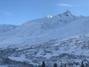
Three Pigs: Nearly every path on the SE face ran with debris deposits stopping in the top 1/3 of aprons, thick alders prevented slides from running full path. These were mostly D3 avalanches.
40.5 Mile Peak: Many paths running similar to Three Pigs, with one running full path to the Tsaina river. Mainly W-NW aspects, D3’s
Max High (Peak on the southern extent of Hippie Ridge) had a D3 avalanche with a crown near 5500′,SW aspect.
Upper Catchers Mitt bowl E aspect, slid R4-D3 ,triggering further avalanches lower down.
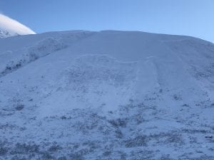
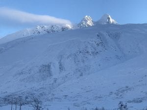
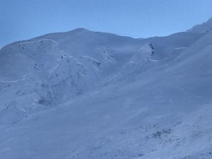
The main activity noted, was on the buttresses on the east side of the pass, from Cracked Ice through North Odessey Gully. Every buttress had significant avalanche activity originating ~4000-5000′. Many of these failed at the ground, north – northwest aspect. Pictures below.
School Bus and North Odyssey Gully both ran with debris in the runouts.
Many other large to very large natural avalanches occurred.
12/2- DOT reported a natural D2.5-3 avalanche that hit the Lowe river at Snowslide Gulch.
11/30- Natural avalanche observed on 40.5 mile peak just to the South of the Shovel. West aspect, ~4500′, crown ~200′ wide, poor light prevented further observation. SS-N-R1-D2-U.
11/29: Natural avalanche observed on Billy Mitchell Cry babys shoulder, similar elevation as 11/16 slide but originated a couple hundred meters further west. Released from ~4000′ with a crown length of ~ 200 meters, North aspect, ~ 37°, failed at the ground. HS-N-R2-D2.5-G
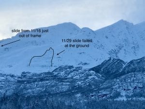
11/16: Natural avalanche observed on Billy Mitchell “Cry babys shoulder”. Released from~3500′ with a crown length of ~200 meters, North aspect. This slide was triggered by recent NE wind cross loading the slope. SS-N-R2-D2-U
11/15: Natural avalanche observed in Loveland Basin on a South aspect, down the ridge from Tones Temple. This slide was triggered by recent NE wind loading and failed at the ground. SS-N-R1-D2-G
Weather
12/6- A 949mb low pressure system in the gulf will be moving towards Prince William Sound and will bring moderate to heavy snow for Thompson Pass. 8-12″ of snow is forecasted for the next 24 hours.
The Thompson Pass Mountain Forecast covers the mountains (above
1000 ft) surrounding Keystone Canyon through Thompson Pass to
Worthington Glacier.

This forecast is for use in snow safety activities and emergency
management.

                   Today        Tonight

Temp at 1000`      26 F         24 F

Temp at 3000`      9-21 F       27-34 F

Chance of precip   90%          90%

Precip amount
(above 1000 FT)    0.40 in      0.43 in

Snow amount
(above 1000 FT)    4-7 in       3-6 in

Snow level         sea level    sea level

Wind 3000` ridges  NE 25-35 mph E 18-27 mph

Remarks...None.
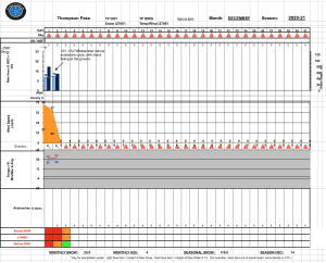
| Date: 12/5 | 24 hr snow (inches) | HN24W (snow water equivalent inches) | High Temp (F) | Low Temp (F) | Weekly SWE Inches (Monday-Sunday) | December snowfall | Season snowfall | HS (snowpack depth inches) |
| Valdez | 0 | 0 | 16 | 5 | 3.71 | 5 | 48 | 23 |
| Thompson Pass | N/O | N/O | 8 | -2 | 5.18 | 35 | 153 | 48 |
| 46 Mile | Trace | ~ | 13 | 6 | 2.84 | 9 | 38 | 14 |
Thompson Pass weather history 20/21. Click on links above the images to see full size view
Additional Information
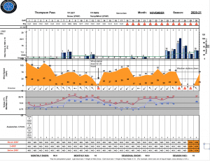
November was mostly dominated by clear, cold and windy weather. On 11/25 a major wx pattern shift occurred which produced 8 days of consecutive storms that delivered 10 inches of water and 90″ of snow to Thompson Pass. This storm fell on a thin snowpack with poor structure near the ground. On 12/1-12/2 a widespread natural avalanche cycle occurred with many avalanches failing at the ground. This event was caused by 4.6″ of SWE on Thompson Pass in a 72 hour period along with rising temperatures bringing the freezing line up to 3000′.
NE winds began 12/4 and have redistributed the storm snow onto lee aspects. This wind event has not been widespread and appears to be concentrated to areas in close proximity to Thompson Pass.
Announcements
The avalanche hazard is Considerable. Triggering a wind slab avalanche 1-2 feet deep remains likely in specific locations. These include cross loaded gullies, and top loaded south aspects. Signs of wind slab include: snow that has a hollow drum like feel, shooting cracks, pillowed snow surfaces and areas where snow becomes significantly deeper over a short distance. The hazard will be lower in protected areas that were not exposed to wind.
The hazard will remain steady through the day. Watch for the possibility of storm slabs beginning to form if snowfall rates are greater than forecasted.
For more information click the (+full forecast) button below.
Your observations are valuable! If you have been out recreating in the mountains, please leave an observation.