Haines Avalanche Center
Above 2,500ftConsiderable
1,500 to 2,500ftModerate
Below 1,500ftLow
The Avy Rose shows the forecasted danger by elevation and aspect. It adds more detail about where you are likely to find the dangers mentioned in the forecast. The inner circle shows upper elevations (mountain top), the second circle is middle elevations, and the outer circle represents lower elevations. Think of the Rose as a birds-eye view of a mountain, looking down from above. The rose allows our forecasters to visually show you which parts of the mountain they are most concerned about.
Degrees of Avalanche Danger
Avalanche Problems
Problem 1
Confidence: Low-Moderate
Elevation: From 2,500ft to 4,000ft
Our alpine snowpack in all zones contains one or more rain crusts from mid October. Weak facetted snow has formed above and below the crust, and has been found to be quite sensitive to the weight of our new snow. Any steep, open pockets of snowpack will be ripe to avalanche on this layer, about 30-60cm deep. We expect this October rain crust will be a lasting problem as we go into winter so keep your guard up! This layer exists on all aspects, but observations are limited and uncertainty is high.
What is the best way to manage this risk? We can simply avoid alpine terrain that is about 30 degrees and steeper. Be aware that venturing on these steeper alpine slopes is relatively high risk currently. Persistent slabs require a wide safety buffer.
Another way to reduce your exposure to these deep weak layers would be to stick to areas of deeper snowpack (>1m deep). But be wary of hidden rocks that can act as trigger points, and thin areas around the margins of a slab.

Likelihood:
- Almost Certain
- Very Likely
- Likely
- Possible
- Unlikely
Size:
- Historic
- Very Large
- Large
- Small
Trend
- Increasing
- Steady
- Decreasing
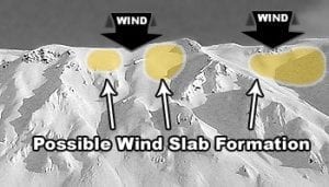
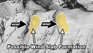
Problem 2
NW winds are howling 20-30mph. As these winds drift the new snow around, they create new wind slabs beneath any ridges and terrain features. Expect these new wind slabs to be sensitive to human triggering. High SE aspects will be the most wind-loaded and the most prone to human and natural avalanches. Human triggered avalanches will be likely today in wind loaded alpine terrain.

Likelihood:
- Almost Certain
- Very Likely
- Likely
- Possible
- Unlikely
Size:
- Historic
- Very Large
- Large
- Small
Trend
- Increasing
- Steady
- Decreasing
Weather
October brought in heavy snow in the alpine, followed by a few rain/sun crusts. November was mostly dry until mid month, when 24-30″ of snow fell.
Friday and Saturday will bring in clearing skies and strong Northwest winds. Temperatures in the alpine will be cold! Barely reaching the single digits Fahrenheit. Wind chills may be brutal. The next storm is on tap for Saturday night-Monday when 6-12″ of new snow is likely.
| Snow Depth [in] | Last 24-hr Snow/SWE [in] | Last 3-days Snow/SWE [in] | Today’s Freezing Level [ft] | Today’s Winds | Next 24-hr Snow/SWE | |
| Mount Ripinsky @ treeline | 30″ | 1″ / 0.10* | 15″ / 1.50* | 0′ | strong, N | 0″ / 0.00* |
| Flower Mountain @ treeline | 40″ | 1″ / 0.10 | 14″ / 1.40 | 0′ | strong, NW | 0″ / 0.00* |
| Chilkat Pass @ 3,100ft | 26″ | 5″ / 0.30 | 7″ / 0.40 | 0′ | strong, NW | 0″ / 0.00* |
( *star means meteorological estimate )
Additional Information
In November, onX Backcountry is donating $10 of every membership to support forecasting. By leveraging their Slope Angle and Avalanche Forecast layers you’ll have access to the tools that help inform safer backcountry travel this year.
Practice like you play. Make sure all your rescue gear is fully functional and your beacon has NEW batteries. Make sure 1) everyone in the group has a functioning beacon, shovel and probe 2) knows how to use them and 3) has trained in companion rescue in the last year. Keep your skills fresh. If you head into the hills, watch out for red flag avalanche conditions, natural avalanches, whoomphing or collapsing, and shooting cracks.
Education Video Links:
- AIARE
- How to Practice Avalanche Rescue Snowmobile Edition: https://youtu.be/2ML499MMDfM
- AK Sled Shed Motorized Learning:
- Intro: https://youtu.be/aoagKHfGkxs
- Personal Electronics in Avalanche Terrain: https://youtu.be/2Vz9S0OEyFk
- Snowmobile Macgyver Tool Kit: https://youtu.be/4WBNu_t6Bbk
- Head and Face Protection: https://youtu.be/jIzW89wOyZI
- Pre-season prep: https://youtu.be/zJmrb8cZlR4
- My Transceiver: https://youtu.be/yblaDWP7Jf8
- BCA Avalanche Safety for Snowmobilers
- How to Fix Common Snowmobile Problems in the Field: https://youtu.be/g9fiTxEvuFk
- Sleducation: Avalanche Safety for Snowmobilers: https://youtu.be/EWFOd_9DYb8
- Intro to Avalanche Transceivers for Snowmobilers: https://youtu.be/6ZLSBmsceog
- Avalanche Transceiver Trailhead Test for Snowmobilers: https://youtu.be/rWoXbadFBsY
- Avalanche Transceiver Searching Use Snowmobiles: https://youtu.be/w1ucyI6LMXM
- BCA Avalanche Rescue Series
- Beacon Search 101: https://youtu.be/nnHXLVA2FcE
- Avalanche Probing 101: https://youtu.be/-0_yDN5Drzw
- Avalanche Shoveling 101: https://youtu.be/dGQg9o3vAkM
- Organizing a Backcountry Rescue: https://youtu.be/gywtmukgt8s
- Post Avalanche Patient Care: https://youtu.be/9FyIeUy4wpQ
- Backcountry Evacuation: https://youtu.be/WPF-dciefL8
- Complex Multiple Burials Backup Techniques: https://youtu.be/pB6AfY2KyYo
- National Avalanche Center
- Avalanche Problems Explained: https://youtu.be/DkbnT_9-cHU
- Intro to North American Avalanche Danger Scale: https://youtu.be/r_-KpOu7tbA
Announcements
Click the –Full Forecast– button below for more details. We need your observations! Forecasts will be issued every THU, FRI, SAT, SUN.