Valdez
Above 4,000ftConsiderable
2,000 to 4,000ftConsiderable
Below 2,000ftConsiderable
Degrees of Avalanche Danger
Avalanche Problems
Problem 1

Likelihood:
- Almost Certain
- Very Likely
- Likely
- Possible
- Unlikely
Size:
- Historic
- Very Large
- Large
- Small
Trend
- Increasing
- Steady
- Decreasing
Problem 2

Likelihood:
- Almost Certain
- Very Likely
- Likely
- Possible
- Unlikely
Size:
- Historic
- Very Large
- Large
- Small
Trend
- Increasing
- Steady
- Decreasing
Problem 3

Likelihood:
- Almost Certain
- Very Likely
- Likely
- Possible
- Unlikely
Size:
- Historic
- Very Large
- Large
- Small
Trend
- Increasing
- Steady
- Decreasing
Avalanche Activity
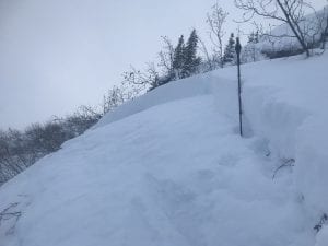
2/6: 2 remote triggered avalanches on RFS at 1800-2000′.
- SS-ARr-R1-D1-O, N aspect, 60′ wide, 50 cm crown, 1800′, failed on buried near surface facets.
- SS-ARr-R3-D1.5-O, N aspect, 100′ wide, ~60 cm crown, 2000′, failed on buried near surface facets.
Photo of 1st remote trigger listed
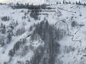
-Natural avalanches observed on south aspect at mile 40, ~1800′, 1-2 feet deep and ~100′ wide. SS-NL-R2-D1.5-O. These were triggered by small snow sluffs.
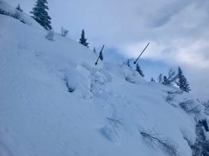
2/2: Numerous Small pockets of unsupported terrain released naturally in the tsaina valley 2′ deep.
1/27-1/30: Naturals were observed on RFS, N aspect ~6000′,
Avalanches were also observed on -40.5 mile, ~5000′ ,W aspect, 60 m crown
– 2 paths on Three Pigs, ~5000′, SE aspect, ran into the top 1/3 of aprons.
– 3 slides on Billy Mitchell ranging from 3000′-6000′, NW- N aspect. The most significant was on the upper bowl of cry babys, ~5000′, ~200 m crown, 1-2 meters deep.
1/23- Found fresh debris in a gully off point 3848′ behind the airport. D2, ran ~2000′.
~ 1/10- There have been several natural windslabs that have released in the Thompson Pass region:
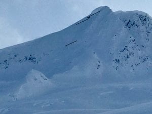
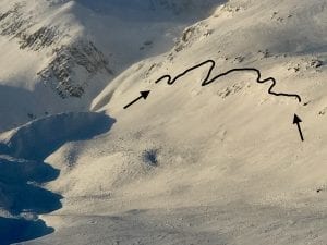
-South slope of catchers mitt, near 27 mile icefall,~3500′, ~300m wide ,~3′ deep, ran 500′ HS-N-R3-D2.5. Photo shows extent of crown, which may have been bigger and is now filled in by wind transported snow.
– Gully Between Little and Big Oddessey, NW, 4000′, ~60 M wide, ~2-4′ crown, ran 1000′
-Averys, ~4000′, SW, ~70 M wide, ran ~1000′
1/11- Two natural wind slab avalanches observed at moonlight basin, 2500′-2800′, S aspect.
The first was on the small last roll before the road and had debris chunks up to 3′ deep “crown filled in by wind”, 200′ wide.
The second was in a cross loaded gully ~ 300′ above the road, with a crown up to ~10′ deep, ~100′ wide. 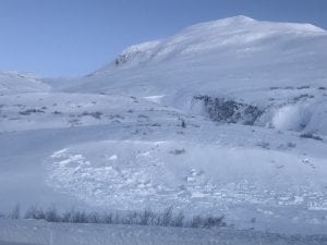
Weather
The Thompson Pass Mountain Forecast covers the mountains (above
1000 ft) surrounding Keystone Canyon through Thompson Pass to
Worthington Glacier.

This forecast is for use in snow safety activities and emergency
management.

                   Today        Tonight

Temp at 1000`      33 F         26 F

Temp at 3000`      25 F         25 F

Chance of precip   80%          70%

Precip amount
(above 1000 FT)    0.33 in      0.16 in

Snow amount
(above 1000 FT)    2-4 in       2-3 in

Snow level         500 ft       sea level

Wind 3000` ridges  S 4-12 mph   SE 5-18 mph

Remarks...None.
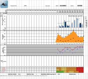
| 24h snowfall (inches) | HN24W (inches)* | Hi Temp (F) | Low Temp (F) | February snowfall | Season Snowfall | Snow height | |
| Valdez | 2 | .06 | 35 | 27 | 14 | 121 | 48 |
| 46 mile | 0 | 0 | 35 | 19 | 7 | 68 | 24 |
|
Thompson Pass “DOT” |
– | – | 27 | 22 | 16 | 376 | 84 |
HN24W= total water received last 24 hours in inches
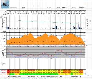
Thompson Pass weather history 19/20 season beginning 12/21 through 1/23. Click on links below to see full size image.
Additional Information
Prolonged arctic temperatures in January have created a weak snowpack. Weaknesses in our snowpack are pronounced at old rain crusts where moisture was once concentrated, and has now formed facets.
The upper snowpack will be undergoing a significant change this week. Snowpacks do not like big changes, especially weak ones. Temperatures have risen to above freezing at sea level for the first time in over a month, and heavy precipitation is forecasted for Saturday through Sunday. This will cause the upper part of the snowpack to become top heavy and will put additional stress on faceted layers. These factors could lead to weak layers becoming more reactive this weekend.
Careful snowpack assessment will be essential this weekend.
Forecast Confidence is Moderate.
Resolution is Low especially at high elevations.
Near surface facets found at 3000′ on Billy Mitchell 1/19. 2 MM grid.
There have been limited observations from interior locations due to low snow at lower elevations. Use caution if you travel in these areas.
If you see something in the mountains that could contribute to this forecast, leave a public observation. The more observations we receive, the better we can tune our forecast. If you would rather not post an observation publicly, feel free to send me an email at [email protected]
Be aware that the elevation bands have changed on our website. Low is now below 2000′, Mid is 2000-4000′ and high is 4000′ and above.
Announcements
The avalanche hazard is considerable at all elevations. Warming temperatures and light to moderate snowfall is creating a top heavy snowpack. With continued warm temperatures and snowfall, stress is slowly being added to a weak snowpack and will cause the hazard to increase through the weekend. Human triggered avalanches are likely today, especially in the low and mid elevation bands. Avoid travel in or below large avalanche paths and terrain traps.