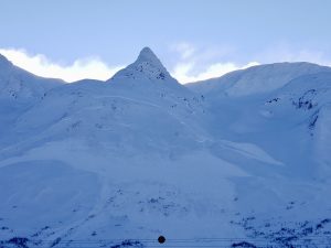
Valdez
Above 3,000ftConsiderable
1,500 to 3,000ftModerate
Below 1,500ftModerate
Degrees of Avalanche Danger
Avalanche Problems
Problem 1
Northeast winds have been forming windslabs 1- 3 feet deep in wind channeled terrain. Older windslabs that formed at the tail end of the storm were becoming stubborn to triggers on 1/29. As winds increase in speed today they may also increase in distribution. Meaning, that some areas that were unaffected by wind will begin to form fresh wind slabs on 1/30. Use caution if you travel in an area today were unconsolidated snow is beginning to be redistributed by wind, or where wind slabs are still showing signs of instability such as shooting cracks. Although older wind slabs are beginning to lock up, triggering one of these remains a possibility in specific places such as cross loaded gullies and the lee side of terrain features. As wind slabs becoming stiffer they have the potential to fail once a person is well onto the slab and may propagate longer distances than a softer slab would.
Snow texture can be a good indicator as to wind direction and where slabs will exist, fresh wind lips will point towards wind slabs. Red flags such as shooting cracks will often exist where sensitive wind slabs are present.
Wind slabs may be able to step down to deeper layers in the snowpack creating very large avalanches (see problem 2).

Likelihood:
- Almost Certain
- Very Likely
- Likely
- Possible
- Unlikely
Size:
- Historic
- Very Large
- Large
- Small
Trend
- Increasing
- Steady
- Decreasing
Problem 2
In many locations developed facets exist in our mid to lower snowpack. Lately, these facets have been stressed by continued heavy precipitation and wind adding weight to lee aspects. Natural persistent avalanche activity on 1/28-1/29 in the Continental and Intermountain zones is a clear indicator that weak/faceted snow in our mid-lower snowpack can still be reactive. The depth of this weak snow is highly variable upon location and elevation. The depth of weak faceted snow from the early winter will directly correlate with the likelihood of triggering a persistent slab avalanche. The closer the layer is to the surface the more likely it becomes to trigger one of these large avalanches. Staying clear of steep rocky areas or places with thin snow pack will greatly lower the risk of triggering a persistent slab avalanche.
Wind slabs may be able to step down to these weak layers in specific locations creating very large destructive avalanches. The most likely place to encounter this avalanche problem is the Intermountain or Continental zone in thin rocky areas where weak faceted layers are closer to the surface and more easily affected.
(2mm grid) Photo of chained facets found in the low elevation area of Girls Mountain 1/13. In many areas these facets are capped by knife hard wind slabs making them difficult to affect and detect.


Likelihood:
- Almost Certain
- Very Likely
- Likely
- Possible
- Unlikely
Size:
- Historic
- Very Large
- Large
- Small
Trend
- Increasing
- Steady
- Decreasing
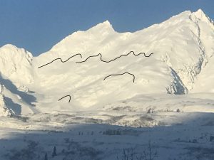
Avalanche Activity
1/30-Several natural persistent slab avalanches were observed in the intermountain and continental zone.
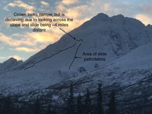
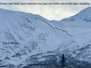
- The most interesting natural avalanche occured on the Little Matterhorn buttress/ North/ ~3500′. This avalanches’ width implies that it was more than a wind slab avalanche and failed on a persistent weak layer. The interesting thing was the depth being much shallower than other persistent slabs that have been noted. Debris from this slide deposited further upslope than a deeper slide with more mass would have in the same spot. The takeaway point is that our area has a lot of spatial variability, meaning that dangerous facets snow may be buried deep in some areas making it very difficult to affect. And in other areas weak faceted snow from November exists close to the surface in some locations, making it easier to affect. Use caution in steep areas with thin snowpack.
- Little Girls/SE aspect/ ~3500′. D2 Natural persistent slab avalanches
- Natural D3 persistent slab avalanche Pt 6153 just north of Averys/ ~5500′
Natural D3 Persistent slab avalanche/ Shovel/ northeast aspect/~5000′.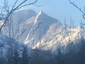
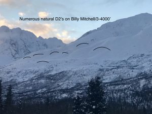
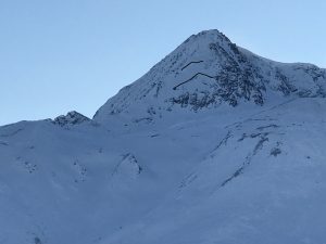
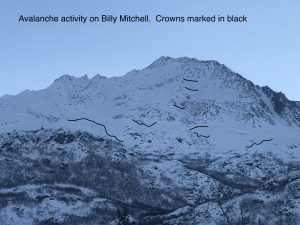
1/29- Observed numerous D2 avalanches on Billy Mitchell (cry babies area) and one D3 on Happiness. These were all northerly aspects. On Billy, slides originated between 3-4000 feet and on Happiness ~5000′.
1/28- During brief break in the clouds, observed a Natural D3 avalanche on Catchers Mitt. It is likely this slide failed on a persistent weak layer, as the crown was deep (3-4) feet and ran a considerable distance.
1/22-1/24- A D3 natural avalanche was observed on 1/22 in snow slide gulch that ran to just below the summer trail.
On 1/26 2-D3 naturals were seen on the east face of Mt Tiekel (beyond forecast zone) that ran half way through their aprons. These likely occured between the 1/22-1/24 time period.
Clouds prevented observation of where these slides originated
1/22- Clouds made observing avalanche activity difficult, although numerous large wet loose slides were observed on south aspects of Town Mountain in the Port of Valdez.
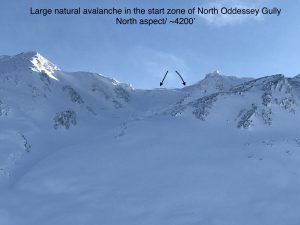
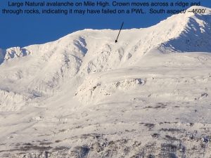
1/13- Multiple large natural avalanches were noted following the snowfall on 1/13. Most were near high elevation ridge lines, although mid elevation storm slabs were noted on north aspect of Catchers Mitt and south aspect of Mile high. Other avalanche not shown in photos include Goodwills north aspect and Oddeyssey north aspect.
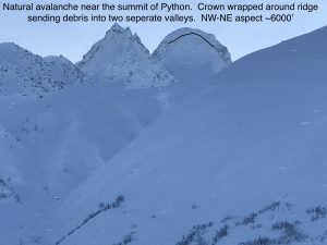
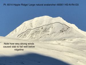
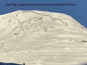
1/1-1/4- The new years day wind event created an avalanche cycle that was difficult to document due to crowns being rapidly reloaded by 80 mph winds. Below are photos of a couple very large slides that were still visible in the Hippie ridge area. Naturals were also noted on Three Pigs, 40.5 Mile, Crudbusters, Python Buttress.
12/29- Multiple natural wet loose D1-D2’s were observed in the Port of Valdez with no step downs noted.
12/23- Berlin Wall north face ~5000′ HS-N-R3-D2-O. It is possible this occurred on 12/21, although it was not observed until 12/24.
12/21- Numerous natural avalanches observed all along the north side of Thompson Pass, as a result of strong NE wind event along with a couple inches of new snow and rising temperatures. Observed naturals on all aspects except windward slopes with crowns originating from 1000 feet to 5500 feet in elevation. Most of these were hard slab avalanches. Crown depths were difficult to discern due to reloading, although some crowns looked to be up to 2 meters in depth.
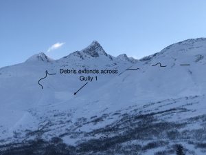
12/19- D 2.5 natural avalanches were observed on the north facing buttress west of Gully 1 and Schoolbus.
12/14- Several natural avalanches were observed although poor visibility prevented a full view of the action. The most notable natural was observed in Nicks Happy Valley on a NW aspect ~4000′. Crown depth was not visible. Debris ran down the valley and piled up at the typical snowmachine pickup.
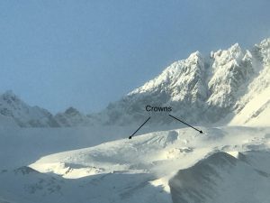
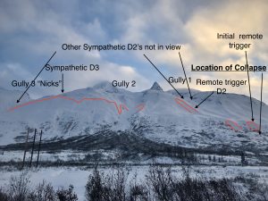
12/8- Large remote trigger/ sympathetic avalanche event occurred 12/8 with avalanches extending from Gully 1 to Nicks. Avalanches were soft slabs that ranged in size from D1-D3. Over 10 separate avalanches were counted with crown depths averaging 2-3′. One avalanche had a crown length of half a mile while another was triggered over a mile away from the point of collapse. See observation section for full report and more photos.
12/7- Only a few natural avalanches were noted during the last storm. It is likely there were more during the storm, but crowns may have been filled in by subsequent wind and snow.
D2’s on Town mountain was observed ~3000′
A couple of D2’s were noted in N. Oddessey gully and Big Oddessey.
D2 on 40.5 mile peak ~5500′.
12/2-12/3- Several natural D2 avalanches were noted on south aspects of Three pigs, Hippie Ridge and Averys. These windslab avalanches originated between 4000-5500 feet elevation.
Weather
NWS Watches and Warnings
None
Point forecast for Thompson Pass
Detailed forecast for Thompson Pass (mid elevation 2000-4000′)
DATE             SUNDAY 01/30            MONDAY 01/31
TIME (LT)        06    12    18    00    06    12    18    00    06
CLOUD COVER      FW    FW    FW    CL    CL    CL    CL    FW    BK
CLOUD COVER (%)  25     5     5     5     0     0     0    20    60
TEMPERATURE      12     8     3     0     0     7     2     1     7
MAX/MIN TEMP                 13          -1           9          -1
WIND DIR         NE    NE    NE    NE    NE    NE    NE    NE     E
WIND (MPH)       21    21    19    14    12    11     6     5     6
WIND GUST (MPH)              37    34    33
PRECIP PROB (%)  10     0     0     0     0     0    10    10    20
PRECIP TYPE                                                       S
12 HOUR QPF                0.00        0.00        0.00        0.00
12 HOUR SNOW                0.0         0.0         0.0         0.0
SNOW LEVEL (KFT)0.0   0.0   0.0   0.0   0.0   0.0   0.0   0.0   0.0
Snow and Temperature Measurements
| Date: 01/30 | 24 hr snow | HN24W* | High Temp | Low Temp | Weekly SWE (Monday- Sunday) | January Snowfall | Season Snowfall | HS (Snowpack depth) |
| Valdez | 1 | .05 | 36 | 15 | 2.48 | 75 | 158 | 49 |
| Thompson Pass | N/O | N/O | 19 | 14 | – | 76 | 241 | 48 |
| 46 Mile | Trace | Trace | 23 | 13 | 1.09 | 57 | 86** | 36
|
All snowfall measurements are expressed in inches and temperature in Fahrenheit. 24 hour sample period is from 6am-6am.
* 24 hour snow water equivalent/ SWE.
** Season total snowfall measurements for 46 mile began December 1st.
Season history graphs for Thompson Pass
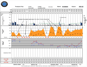
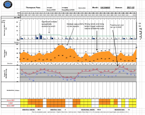
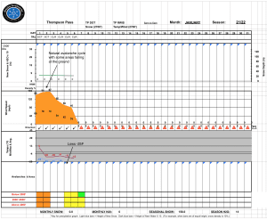
Click on links below to see a clear and expanded view of above Season history graphs
Additional Information
Winter weather began early this season, with valley locations receiving their first snowfall on the last day of Summer (September 21st). Following this storm, above average temperatures and wet weather occurred from late September through early November. During this time period Thompson Pass received 96 inches of snowfall by November 7th and Valdez recorded 7.73″ of rain.
After the 7th of November our region experienced a sharp weather pattern change. Temperatures dropped below seasonal norms and snowfall became infrequent. Between the time frame of November 7th- November 28th Thompson Pass only reported 19″ of snow with 1.1″ of Snow water equivalent (SWE). Temperatures remained below 0° F for most of the period. This cold/dry weather caused significant faceting of the snowpack, with poor structure the result.
Moderate snowfall returned to our area the last day of November and deposited 6-12 inches of new snow. The amount varied depending upon the locations’ proximity to the coast. As the storm exited on the 2nd of December it was quickly replaced by moderate to strong northeast winds.
On 12/5-12/6 Valdez received 2 feet of new snow with Thompson Pass reporting 16″. Blaring red flags like collapsing, shooting cracks and propagation in stability tests were immediately present. On 12/8 a significant remote/ sympathetic avalanche event occurred from Gully 1 through Nick’s Happy Valley.
Strong outflow winds began on 12/11 with periods of light snowfall. This has caused slab thicknesses to become variable in areas exposed to NE winds.
A fair amount of natural avalanche activity occurred during the 12/11 wind event mostly on southerly aspects. The week following this wind event fairly benign weather occurred which allowed the snowpack to adjust and for stability to improve although snowpack structure has remained poor.
On 12/21 our area received a couple inches of snow along with temperatures rising and strong outflow winds. This combination of weather kicked off a fairly significant natural avalanche cycle. Many of the slabs appeared to be deeper wind slabs that were created from the 12/11 wind event. These failed on faceted snow created in November. The event is yet another indicator of our poor snowpack structure and its inability to receive any major change in weather without the avalanche hazard rising in conjunction.
On 12/26-28 warm air moved in at elevation and caused light rain to fall up to ~4000′. A very thin rain crust was formed in many locations that was unable to support a persons weight.
A prolonged period of strong north winds began on new years day with wind speeds reaching 80 mph. As winds tapered to 30-40 mph on the 5th temperatures plummeted with lows exceeding -30 F in the Tsaina valley.
Snowfall returned to our area on 1/13 with a foot of snow reported on Thompson Pass. An additional ~6 inches of snow were received on 1/15 with settled storm totals of 2.5 feet above 5000′.
Moderate outflow winds kicked up on 1/16, but were short-lived and not wide spread. This was followed by two days of calm and mild weather.
Stormy weather returned to our area on 1/19 with 10 consecutive days of measurable precipitation. The Initial change in weather brought ~1 foot of dry snow which was quickly followed by a big warmup from 1/21-1/24, with snow line rising to 3000′. This caused the snowpack to go upside down at the surface which created a decent amount of natural wet/loose activity near sea level and a couple D3 slab avalanches on Snowslide Gulch and Mt.Tiekel. Observation of avalanche activity was limited due to continued storms and crowns being filled back in.
After 1/24, precipitation continued with temperatures slowly dropping and snow line returning to sea level. Precipitation ended on 1/29 with moderate northeast winds building wind slabs as skies cleared.
Snow water equivalent storm totals for 1/19-1/28 are as follows:
Valdez: 6.73″
Thompson Pass: 4.3″ (1/19-1/26)
46 Mile: 1.93″
Announcements
The avalanche hazard is Considerable above 4000 feet. Human triggered avalanches are likely in specific locations. The most likely place to trigger an avalanche will be the lee side of high elevation ridge lines, cross loaded gullies and areas that are receiving active wind loading today for the first time since the last snowfall. Watch for signs of wind slabs and their sensitivity by looking for shooting cracks and areas being actively loaded by wind.
Click the + Full Forecast button below for a list of current avalanche problems, travel advice, weather resources and more.
Help to improve your local avalanche center and contribute an observation to the website. You can also contact me directly at [email protected] (907) 255-7690.